Maps of Northern European Plain

Tabula Moderna Norbegie Et Gottie. [Karte], in: Claudii Ptolemei viri Alexandrini mathematice discipline philosophi doctissimi geographie opus [...], S. 251.
1 Karte aus Atlas Waldseemüller, Martin [und Ptolemaeus, Claudius] Übelin, Georg
Reiche der Nordmannen vom VIIIten. bis in's XIIte. Jahrdndt.
1 : 11000000 Spruner von Merz, Karl
Europe.
1 : 20000000 Woodbridge, William C.
Schweden und Norwegen, Dänemark, Island u. Faer-öer
Hand-Atlas über alle Theile der Erde nach dem neuesten Zustande und über das Weltgebäude Stieler, Adolf bei Justus Perthes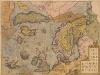
Septentrionalium Regionum Descrip. [Karte], in: Theatrum orbis terrarum, S. 105.
1 Karte aus Atlas Ortelius, Abraham
Swedland and Norway.
from A new systeme of the mathematicks: containing I. Arithmetick, as well natural and decimal, as in species, or the principles of algebra. II. Practical geometry, together with the first six books of Euclid's Elements, as also the eleventh and twelfth, symbo
Septentrionales Regiones XVIII. No. Tab. [Karte], in: Claud. Ptolemaeus. Geographia lat. cum mappis [...], S. 410.
1 Karte aus Atlas Münster, Sebastian [und Ptolemaeus, Claudius]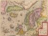
Septentrionalium Regionum Descrip. [Karte], in: Theatrum orbis terrarum, S. 286.
1 Karte aus Atlas Ortelius, Abraham
Europe.
1 : 15778000 Hammond, C.S.
L'Europe isles, caps, ports.
1 : 13600000 Clouet, J. B. L. (Jean-Baptiste Louis), b. 1730
Europe.
1 : 21542400 Tallis, J. & F.
Scandinavien und Polen, kirchlichen Eintheilung bis zur Reformation.
1 : 9400000 Spruner von Merz, Karl
General-Karte von Europa
1 : 8700000 Evropa Weiland, Karl Ferdinand im Verlage des Geographischen Instituts
(L'Europe)
1 : 100000000 Bruyset, Jean-Marie; Schneider, J. H.
Sweden, and Norway.
from A system of geography, or, A new & accurate description of the earth in all its empires, kingdoms and states : illustrated with history and topography, and maps of every country : fairly engraven on copper, according to the latest discoveries and corrections / by Herman Moll.
Europae recens designatio
1 : 32000000 1 Karte : Kupferdruck ; 11 x 17 cm Weigel, Johann Christoph [Johann Christoph Weigel]
EUROPAE recens DESIGNATIO
Evropa
Statistikk 38: Bosettingskart over Norge. Oversiktskart
Statistisk Sentralbyrå
Europa
1 : 9500000 Evropa Lotter, Tobias Conrad Tob. Conr. Lotter
Evropa
Evropa z c. k. školního kněhoskladu
Europa
Evropa troškom c. k. naklade školskih knjigah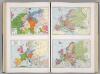
Historical Maps of Europe.
1 : 6897000 Hammond, C.S.
Europa
Evropa Seutter, Matthäus â Math. Seutt.
Europe.
1 : 13000000 Colton, G.W.
Europe.
1 : 21000000 Mitchell, Samuel Augustus
Map of Europe.
1 : 20500000 Mitchell, Samuel Augustus
Map of Europe.
1 : 21000000 Mitchell, Samuel Augustus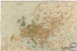
Karte der Bevölkerungs - Dichtigkeit von Evropa

Závěsná mappa [sic] hor a řek Evropy
1 : 4000000 Evropa Haardt von Hartenthurn, Vinzenz von Jireček, Josef Ed. Hölzel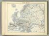
![Tabula Moderna Norbegie Et Gottie. [Karte], in: Claudii Ptolemei viri Alexandrini mathematice discipline philosophi doctissimi geographie opus [...], S. 251.](https://images-2.georeferencer.com/images/iiif/829560428787/full/,300/0/native.jpg)

