Maps of Cork

Feuille 22 (A IV), uit: Carte géologique internationale de l'Europe : la carte, votée au congrès géologique international de Bologne en 1881, est exécutée conformément aux décisions d'une commission internationale, avec le concours des gouvernements, sous le dir. de M.M. Beyrich et Hauchecorne
Annotatie: Blad 48 gamme des couleurs; blad 49: bladwijzer en titelblad Heinrich Ernst Beyrich 1815-1896; Wi. Hauchecorne Berlin : Reimer / (Berlin: Institut lithographique)
Pas caert van 't in komen van de Canael
1 Karte : Kupferdruck ; 42 x 53 cm Doncker bÿ Hendrick Doncker boeckverkoper inde Nieuwbrugh steegh in 't Stuurmans gereetschap
France, Belgium & Holland - political.
1 : 3000000 John Bartholomew and Son
MOMONIA, | Hibernice | MOUN et WOUN; | Anglice | MOUNSTER
[Amsterdam : Joan Blaeu]
Provincia Momoniae. The Province of Mounster. [Karte], in: Novus atlas absolutissimus, Bd. 8, S. 192.
1 Karte aus Atlas Janssonius Offizin
Provincia Momoniae. The Province of Mounster. [Karte], in: Gerardi Mercatoris et I. Hondii Newer Atlas, oder, Grosses Weltbuch, Bd. 1, S. 54.
1 Karte aus Atlas Mercator, Gerhard und Hondius, Jodocus Jansson, Jan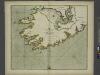
The SOUTH-WEST coast of IRELAND from Dungarvan to the River Shannon
from The sea-atlas : containing an hydrographical description of most of the sea-coasts of the known parts of the world.
Provincia Momoniae = The province of Mounster
1 : 690000 Amstelodami : apud Joannem Janssonium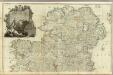
A map of the Kingdom of Ireland (Northern section)
1 : 380000 Rocque, John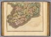
Ireland southern.
1 : 700000 Lizars, Daniel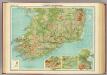
Ireland - southern section.
1 : 633600 John Bartholomew & Co.
Irlandiae Regnum. [Karte], in: Gerardi Mercatoris Atlas, sive, Cosmographicae meditationes de fabrica mundi et fabricati figura, S. 97.
1 Karte aus Atlas Mercator, Gerhard Montanus, Petrus
Irlandiae Regnum. [Karte], in: Atlas, sive, Cosmographicae meditationes de fabrica mundi et fabricati figura, S. 98.
1 Karte aus Atlas Mercator, Gerhard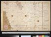
De dieptens en gronden voor het Kanaal
Ireland Gerard van Keulen
Des Königreichs Ireland Provinz Mounster mit dem sudlichen Theile der Provinzen Leinster und Con[n]aught
1 Karte : Kupferdruck ; 20 x 26 cm Reilly F. J. J. von Reilly
Partie meridio.le du royaume d'Irlande
1 Karte : Kupferdruck ; 38 x 47 cm Sanson; Boazio; Speed; Fortin chez Fortin ing.r mecanicien du roi pour les globes rue de la Harpe pres celle du Foin
Partie meridio.le du royaume d'Irlande
1 Karte : Kupferdruck ; 38 x 47 cm Sanson; Boazio; Speed chez l'autheur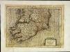
Irlandiæ regnvm
1 Karte : Kupferdruck ; 17 x 24 cm Mercator Cloppenburgh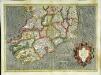
Irlandiae regnvm
1 Karte : Kupferdruck ; 32 x 45 cm Mercator; Hondius Henricus Hondius
Irlandiae regnvm
1 Karte : Kupferdruck ; 32 x 45 cm Mercator; Hondius Jodocus Hondius
Momonia, hibernice Moun et Woun; anglice Mounster
1 Karte : Kupferdruck ; 40 x 50 cm Blaeu Joan Blaeu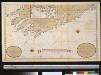
Nieuwe afteekening van de Zuydkust van Irland van de Blasques tot de Hoek van Waterford int groodt
Ireland Gerard van Keulen
Ireland 3.
1 : 760320 Letts, Son & Co.
Karte der Schweizer Alpen : Oestliches Blatt
1 : 250000 Ravenstein, Hans 1866-1934 Frankfurt a. Main : L. Ravenstein
Karte der Schweizer Alpen : Westliches Blatt
1 : 250000 Ravenstein, Hans 1866-1934 Frankfurt a. Main : L. Ravenstein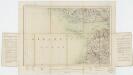
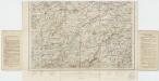
Sheet 9, uit: Ireland
1 : 253440 Annotatie: Voor aanwezige bladen zie overzichtsblad; Alle bladen met aantekeningen in kleurpotlood of inkt; Annotatie geografische gegevens: Maps on the scale of four miles to one inch; Op elk blad een diagram van aangrenzende bladen en een indexdiagram van de corresponderende bladen van de 'one inch map' Dublin : Ordnance Survey of Ireland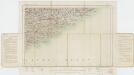
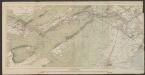
Sheet 16, uit: Ireland
1 : 253440 Annotatie: Voor aanwezige bladen zie overzichtsblad; Alle bladen met aantekeningen in kleurpotlood of inkt; Annotatie geografische gegevens: Maps on the scale of four miles to one inch; Op elk blad een diagram van aangrenzende bladen en een indexdiagram van de corresponderende bladen van de 'one inch map' Dublin : Ordnance Survey of Ireland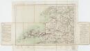
Sheet 12, uit: Ireland
1 : 253440 Annotatie: Voor aanwezige bladen zie overzichtsblad; Alle bladen met aantekeningen in kleurpotlood of inkt; Annotatie geografische gegevens: Maps on the scale of four miles to one inch; Op elk blad een diagram van aangrenzende bladen en een indexdiagram van de corresponderende bladen van de 'one inch map' Dublin : Ordnance Survey of Ireland