Maps of Galway
Sheet 9, uit: Ireland
1 : 253440 Annotatie: Voor aanwezige bladen zie overzichtsblad; Alle bladen met aantekeningen in kleurpotlood of inkt; Annotatie geografische gegevens: Maps on the scale of four miles to one inch; Op elk blad een diagram van aangrenzende bladen en een indexdiagram van de corresponderende bladen van de 'one inch map' Dublin : Ordnance Survey of Ireland
Gallway
3 Karten auf einem Blatt : Kupferdruck ; zusammen 17 x 10 cm Le Rouge Georges Louis Le Rouge
Ireland 3.
1 : 760320 Letts, Son & Co.
Connachtia vulgo Connaughty
1 Karte : Kupferdruck ; 38 x 48 cm Blaeu Joan Blaeu
Provincia Connachtiae The Province of Connaugt [Karte], in: Novus atlas absolutissimus, Bd. 8, S. 198.
1 Karte aus Atlas Janssonius Offizin
CONNACHTIA | Vulgo | CONNAUGHTY
[Amsterdam : Joan Blaeu]
Irlandiae Regnum. [Karte], in: Gerardi Mercatoris Atlas, sive, Cosmographicae meditationes de fabrica mundi et fabricati figura, S. 97.
1 Karte aus Atlas Mercator, Gerhard Montanus, Petrus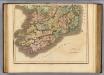
Ireland southern.
1 : 700000 Lizars, Daniel
Provincia Momoniae = The province of Mounster
1 : 690000 Amstelodami : apud Joannem Janssonium
Irlandiae Regnum. [Karte], in: Atlas, sive, Cosmographicae meditationes de fabrica mundi et fabricati figura, S. 98.
1 Karte aus Atlas Mercator, Gerhard
Des Königreichs Ireland Provinz Mounster mit dem sudlichen Theile der Provinzen Leinster und Con[n]aught
1 Karte : Kupferdruck ; 20 x 26 cm Reilly F. J. J. von Reilly
Partie meridio.le du royaume d'Irlande
1 Karte : Kupferdruck ; 38 x 47 cm Sanson; Boazio; Speed; Fortin chez Fortin ing.r mecanicien du roi pour les globes rue de la Harpe pres celle du Foin
Partie meridio.le du royaume d'Irlande
1 Karte : Kupferdruck ; 38 x 47 cm Sanson; Boazio; Speed chez l'autheur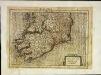
Irlandiæ regnvm
1 Karte : Kupferdruck ; 17 x 24 cm Mercator Cloppenburgh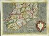
Irlandiae regnvm
1 Karte : Kupferdruck ; 32 x 45 cm Mercator; Hondius Henricus Hondius
Irlandiae regnvm
1 Karte : Kupferdruck ; 32 x 45 cm Mercator; Hondius Jodocus Hondius
Stanford ́s map of Irland

Composite: Ireland.
1 : 380000 Rocque, John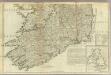
A map of the Kingdom of Ireland (Southern section)
1 : 380000 Rocque, John
Ireland.
1 : 1420000 Flemming, Carl
Ireland.
1 : 1500000 Colton, G.W.
Composite: Ireland.
1 : 486830 Stanford, Edward
Provincia Connachtiae = The province of Connaugt
1 : 790000 Amstelodami : ex officina Petri Schenk et Gerardi Valk
Provincia Connachtiae = The province of Connaugt
1 : 790000 Amstelodami : excudebat Joannes Janssonius
Ireland.
1 : 1650000 Tanner, Henry S.
Provincia Momoniae. The Province of Mounster. [Karte], in: Novus atlas absolutissimus, Bd. 8, S. 192.
1 Karte aus Atlas Janssonius Offizin
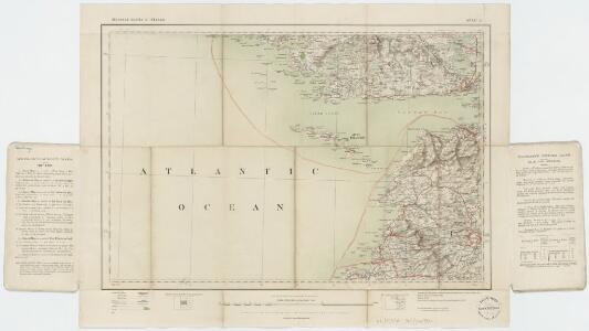
Ireland SW.
1 : 486830 Stanford, Edward
Ireland.
1 : 792443 Johnston, W. & A.K.