Maps of Cork
Irlandiae Regnum. [Karte], in: Atlas, sive, Cosmographicae meditationes de fabrica mundi et fabricati figura, S. 98.
1 Karte aus Atlas Mercator, Gerhard
Irlandiae Regnum. [Karte], in: Gerardi Mercatoris Atlas, sive, Cosmographicae meditationes de fabrica mundi et fabricati figura, S. 97.
1 Karte aus Atlas Mercator, Gerhard Montanus, Petrus
Des Königreichs Ireland Provinz Mounster mit dem sudlichen Theile der Provinzen Leinster und Con[n]aught
1 Karte : Kupferdruck ; 20 x 26 cm Reilly F. J. J. von Reilly
Partie meridio.le du royaume d'Irlande
1 Karte : Kupferdruck ; 38 x 47 cm Sanson; Boazio; Speed; Fortin chez Fortin ing.r mecanicien du roi pour les globes rue de la Harpe pres celle du Foin
Partie meridio.le du royaume d'Irlande
1 Karte : Kupferdruck ; 38 x 47 cm Sanson; Boazio; Speed chez l'autheur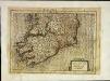
Irlandiæ regnvm
1 Karte : Kupferdruck ; 17 x 24 cm Mercator Cloppenburgh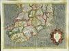
Irlandiae regnvm
1 Karte : Kupferdruck ; 32 x 45 cm Mercator; Hondius Henricus Hondius
Irlandiae regnvm
1 Karte : Kupferdruck ; 32 x 45 cm Mercator; Hondius Jodocus Hondius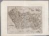
[Recto], uit: Irlandiae regnum / per Gerardem Mercatorem
1 : 2500000 Annotatie: Uit: Gerardi Mercatoris et I. Hondii atlas ... - Amsterdam : Henricus Hondius en Ian Ianssen, 1634; Oorspr. uitg.: 1595; Annotatie geografische gegevens: West boven Mercator, Gerhard [Amsterdam : Henricus Hondius en Ian Ianssen]

A pocket companion of Ireland.
1 : 1700000 Moll, Herman, d. 1732
Provincia Momoniae = The province of Mounster
1 : 690000 Amstelodami : apud Joannem Janssonium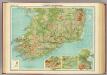
Ireland - southern section.
1 : 633600 John Bartholomew & Co.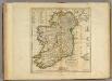
Map of Ireland.
1 : 1450000 Carey, Mathew
Ireland.
1 : 1457280 Carey, Mathew
Map Of Ireland.
1 : 1425600 Carey, Mathew
Map Of Ireland.
1 : 1425600 Carey, Mathew

Provincia Momoniae. The Province of Mounster. [Karte], in: Novus atlas absolutissimus, Bd. 8, S. 192.
1 Karte aus Atlas Janssonius Offizin
Ireland.
1 : 1600000 Colton, G.W.
Ireland.
1 : 740000 Faden, William, 1750?-1836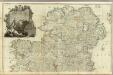
A map of the Kingdom of Ireland (Northern section)
1 : 380000 Rocque, John
Provincia Momoniae. The Province of Mounster. [Karte], in: Gerardi Mercatoris et I. Hondii Newer Atlas, oder, Grosses Weltbuch, Bd. 1, S. 54.
1 Karte aus Atlas Mercator, Gerhard und Hondius, Jodocus Jansson, Jan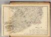
Ireland (south sheet)
1 : 785000 Society for the Diffusion of Useful Knowledge (Great Britain)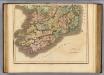
Ireland southern.
1 : 700000 Lizars, Daniel
Ireland.
1 : 840000 Weiland, C. F. (Carl Ferdinand), d. 1847
Composite: Ireland.
1 : 380000 Rocque, John
Charte von Ireland
1 : 1900000 Irsko
CHARTE von IRELAND
1 : 1250000 Irsko
![Irlandiae Regnum. [Karte], in: Atlas, sive, Cosmographicae meditationes de fabrica mundi et fabricati figura, S. 98.](https://images-2.georeferencer.com/images/iiif/704535379695/full/,300/0/native.jpg)

