Maps of León

Pas caert van 't in komen van de Canael
1 Karte : Kupferdruck ; 42 x 53 cm Doncker bÿ Hendrick Doncker boeckverkoper inde Nieuwbrugh steegh in 't Stuurmans gereetschap
De Bocht van Vranckryck oock 't Canaal aen te doen, comende uyten Westen [Karte], in: De Nieuwe Groote Vermeerderde Zee-Atlas ofte Water-Werelt, S. 47.
1 Karte aus Atlas Doncker, Hendrick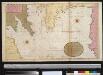
Afteekening van de Bogt van Vrankrijk, een gedeelte van het Canaal als ook t Verkeerde Canaal met de Zuijt cust van Irlandt
Bay of Biscay Gerard van Keulen
Partie, l'Espagne. Europe 18.
1 : 1641836 Vandermaelen, Philippe, 1795-1869
[131][134] Galliae, Biscajae et Gallissiae Sinus ... De Bocht van Vranckryck ..., uit: Atlas sive Descriptio terrarum orbis
Annotatie: Gedigitaliseerde versie. Amsterdam. Heiloo : Picturae (vervaardiger), 2015. tiff-bestand. Gedigitaliseerd: 07-01-2015; Origineel: Universiteitsbibliotheek Vrije Universiteit (XL.05127.-) ; Netherlands; Titelpagina ontbreekt Wit, Frederik de Amsterdam : Frederick de Wit
France, Belgium & Holland - political.
1 : 3000000 John Bartholomew and Son
A large chart of the BAY OF BISCAY
from The sea-atlas : containing an hydrographical description of most of the sea-coasts of the known parts of the world.
Galliæ, Biscajæ et Gallissiæ sinus
1 Karte : Kupferdruck ; 48 x 55 cm Renard gedruckt bÿ L. Renard
Carte du Canal ou de la Manche, 1
1 Blatt : 74 x 52 cm Esnauts et Rapilly
Pas-caert van de bocht van Vranckrijck, Biscajen en Galissen; tusschen Heyssant en C. de Finisterre
1 Karte : Kupferdruck ; 42 x 53 cm Doncker bÿ Hendrick Doncker inde Nieuwbrug steegh in 't Stuurmans gereetschap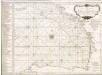
Accurate chart of the Bay of Biscay
Neptune Occidental. A Compleat Pilot for the West-Indies, including the British Channel, Bay of Biscay, and all the Atlantic islands; with their bays, harbours, keys, rocks, land-marks, depths of water, latitudes, longitudes &c. &c. ... Done from actual surveys, by the late Thomas Jefferys ... on twenty-eight large imperial plates. Jefferys, Thomas. London : Printed for R. Sayer and J. Bennett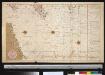
De dieptens en gronden voor het Kanaal
Ireland Gerard van Keulen
Carte des iles britanniques ou Royaume-Uni de la Grande Bretagne et d'Irlande, 5
2 Blätter : je 50 x 39 cm
Atlantischer Ozean
1 : 600000 Atlantský oceán Admiralität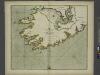
The SOUTH-WEST coast of IRELAND from Dungarvan to the River Shannon
from The sea-atlas : containing an hydrographical description of most of the sea-coasts of the known parts of the world.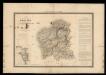
Mapa de Galicia con las nuevas divisiones
1 Mapa. Atlas Nacional de España Dufour, A.H. 0
Le royaume de Galice divisé en plusieurs territoires, et les Asturies divisees en Asturie d'Oviedo et de Santillana
1 Karte auf 2 Blättern : Kupferdruck ; 43 x 71 cm Nolin; Rousseau; Silva; Julien chez le Sr. Julien a l'hotel de Soubise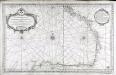
Carte reduite du golphe de Gascogne
1 Karte : Kupferdruck ; 53 x 84 cm Bellin s.n.
MOMONIA, | Hibernice | MOUN et WOUN; | Anglice | MOUNSTER
[Amsterdam : Joan Blaeu]
Le royaume de Galice
1 Karte : Kupferdruck ; 43 x 47 cm Fer chez le Sr. de Fer dans l'isle du Palais sur le Quay de l'Orloge a la sphere royale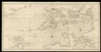
An exact trigonometrical survey of the British Channel, including the mouth of the Thames and Part of the German sea with the coast of Irland from Carnsore point to the Shannon Mouth
Laurie & Whittle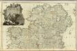
A map of the Kingdom of Ireland (Northern section)
1 : 380000 Rocque, John
Provincia Momoniae. The Province of Mounster. [Karte], in: Gerardi Mercatoris et I. Hondii Newer Atlas, oder, Grosses Weltbuch, Bd. 1, S. 54.
1 Karte aus Atlas Mercator, Gerhard und Hondius, Jodocus Jansson, Jan
Provincia Momoniae = The province of Mounster
1 : 690000 Amstelodami : apud Joannem Janssonium
Gallaecia, Regnum [Karte], in: Novus Atlas, das ist, Weltbeschreibung, Bd. 2, S. 225.
1 Karte aus Atlas Blaeu, Joan Blaeu, Willem Janszoon
Gallaecia, Regnum [Karte], in: Theatrum orbis terrarum, sive, Atlas novus, Bd. 2, S. 223.
1 Karte aus Atlas Blaeu, Joan Blaeu, Willem Janszoon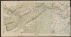
Irlandiae Regnum. [Karte], in: Gerardi Mercatoris Atlas, sive, Cosmographicae meditationes de fabrica mundi et fabricati figura, S. 97.
1 Karte aus Atlas Mercator, Gerhard Montanus, Petrus
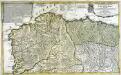
GALLÆCIA, | REGNVM
descripta a F. Fer. Ojea Ord. Præd. | et postmodum multis in locis | emendata et aucta Apud Guilj. Blaeu.


