Maps of Seven Seas (Open Ocean)

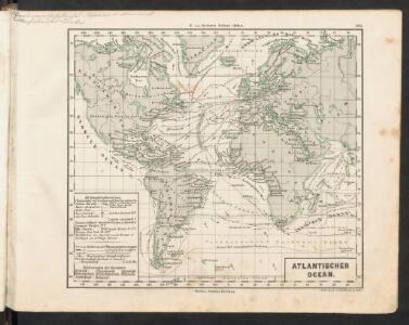
Atlantischer Ocean
E. von Sydow's Schul-Atlas in sechs und dreissig Karten Sydow, Emil von bei Justus Perthes
Le monde ou panorama géographique du globe terrestre, représentant les terres et les mers du globe, ses accidents physiques, les phénomènes, les règnes de la nature [...]
1 : 177600000 réd. d'après Mr. De Humbold et les savans les plus distingués par E. Hocquart [S.l.] : [s.n.]
Atlantic Ocean.
1 : 95000000 Huntington, Hezekiah, 1795-1865
America
A new general atlas of modern geography, consisting of a complete collection of maps of the four quarters of the globe Wyld, James James Wyld
Calculus Eclipsis Solis Observatae die 19. Novemberis 1816

Atlantic Ocean.
1 : 49000000 Goodrich, S.G.
Animals - World.
Woodbridge, William C.
Mappe-Monde = Geo-Hydrographique, ou Descritption Generale Du Globe Terrestre Et Aquatique En Deux-Plans-Hemispheres. [Karte], in: Atlas nouveau, contenant toutes les parties du monde [...], Bd. 1, S. 32.
1 Karte aus Atlas Sanson, Nicolas Jaillot, Alexis Hubert und Mortier, Pieter
Isothermal chart, productions.
1 : 80000000 Woodbridge, William C.
Carte physique de l'ocean où l'on voit des grandes chaînes de montagnes qui traversent les continents d'Europe, d'Afrique et d'Amérique
1 Karte : Kupferdruck ; 27 x 34 cm, Blattgrösse 47 x 62 cm Buache; Desbruslins Philippe Buache
L'Ocean.
1 : 70000000 Buache, Philippe, 1700-1773
Inhabited World.
1 : 93000000 Woodbridge, William C.
Mappemonde philosophique et politique, où sont tracés les voyages de Cook et de La Pérouse
1 : 62000000 par L. Brion, père [...] Paris : chez l’auteur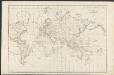
Allgemeine Weltcharte
1 : 45400000 nach Mercators Projection entworfen von A.I. Krusenstern, Capitain der Russischen Marine J. Walker sculpt. ; verb. bis zum Jahre 1818. London : [s.n.]
Hydrographical chart of the world on Wright or Mercator projection
země světa Thomson, John Scott, R.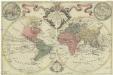
Mappa totius mundi
země světa Delisle, Guillaume Lotter, Tobias Conrad apud Tobiam Conradum Lotter
Isothermal chart.
1 : 95000000 Woodbridge, William C.
Vorstellvng der in der Nacht zwischen den 8. u. 9. Aug; 1748
Mollova mapová sbírka Mayer, Tobias Homann, Johann Baptista - dědici
Die verfinsterte Erdkugel :
Mollova mapová sbírka Lowitz, Georg Moriz Schneider, Ruprecht Adam Homann, Johann Baptista - dědici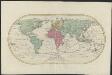
Mappemonde ou Carte générale de l' univers sur une projection nouvelle d'une sphére ovale pour mieux entendre les distances entre l'Europe et Amerique : avec le tour du monde du lieut. Cook et tous les découvertes nouvelles
1 : 45000000 dessinée et gravée par Mathieu Albert Lotter A Augsbourg : [s.n.]
Grosser oder Stiller Ocean
E. von Sydow's Schul-Atlas in sechs und dreissig Karten Sydow, Emil von bei Justus Perthes
Westliche Halbkugel
Neuester Schul-Atlas Walch, Johann im Verlag bei Joh. Walch
Versuch einer Karte zur Übersicht der Fluthwellen
Erster Band, enthaltend in vier Abtheilungen die Erscheinungen der anorganischen Natur: 1. Meteorologie und Klimatographie. 2. Hydrologie und Hydrographie. 3. Geologie. 4. Tellurischer Magnetismus Humboldt, Alexander von Verlag von Justus Perthes
Atlas über die Entwicklung von Industrie und Handel der Schweiz in dem Zeitraume vom Jahr 1770 bis zum Jahr 1870
1 : 500000 Absatzgebiete des Schweizerischen Ausfuhrhandels 1870 Wartmann, Hermann Wurster Randegger & Co.
Atlas über die Entwicklung von Industrie und Handel der Schweiz in dem Zeitraume vom Jahr 1770 bis zum Jahr 1870
1 : 45000000 1 Atlas ([3], VIII Bl.) im Auftrage der schweizerischen Commission für die additionellen Ausstellungen in Wien, bearbeitet von Dr. Hermann Wartmann Wurster Randegger & Co., Winterthur
America
Neuester Schul-Atlas Walch, Johann im Verlag bei Joh. Walch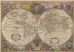
Nova Totius Terrarum Orbis Geographica Ac Hydrographica Tabula. [Karte], in: Novus atlas absolutissimus, Bd. 1, S. 14.
1 Karte aus Atlas Janssonius Offizin
The "time and tide" map of the Atlantic charter / [cartography] London Geographical Institute
1 : 450000 Annotatie: Bevat de 8 punten van het Atlantisch charter The London Geographical Institute, London London : Philip & Son
Nova totius terrarum orbis tabula
1 : 80000000 auctore F. de Wit. t' Amsterdam : bij Frederick de Wit