Maps of Seven Seas (Open Ocean)

Nova Totius Terrarum Orbis Gepgraphica Ac Hydrographica Tabula. [Karte], in: Gerardi Mercatoris et I. Hondii Newer Atlas, oder, Grosses Weltbuch, Bd. 1, S. 25.
1 Karte aus Atlas Mercator, Gerhard und Hondius, Jodocus Jansson, Jan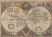
Nova Totius Terrarum Orbis Geographica Ac Hydrographica Tabula. [Karte], in: Novus atlas absolutissimus, Bd. 1, S. 14.
1 Karte aus Atlas Janssonius Offizin
Pharmacognostische Karte zur Pharmacopoea Germanica
1 : 85000000 Schelenz, H. E. [Buchh. des Waisenhauses]
Nova Totius Terrarum Orbis Geographica Ac Hydrographica Tabula [Karte], in: Theatrum orbis terrarum, sive, Atlas novus, Bd. 1, S. 24.
1 Karte aus Atlas Blaeu, Joan Blaeu, Willem Janszoon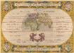
Aevi Veteris, Typus Geographicus. [Karte], in: Theatrum orbis terrarum, S. 359.
1 Karte aus Atlas Ortelius, Abraham
Museumskart 162: Atlasillustrasjon
Christoph Weigel
Übersicht der Mittleren Barometerstände am Meere und der Oscillation des Luftdrucks
Erster Band, enthaltend in vier Abtheilungen die Erscheinungen der anorganischen Natur: 1. Meteorologie und Klimatographie. 2. Hydrologie und Hydrographie. 3. Geologie. 4. Tellurischer Magnetismus Humboldt, Alexander von Verlag von Justus Perthes
Polokoule
země světa
Polokoule zemské
1 : 100000000 země světa Köke, Friedrich C. k. školní kněhosklad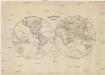
Poloukule [sic] zemské
země světa c. k. školní kněhosklad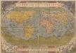
Typus Orbis Terrarum. [Karte], in: Theatrum orbis terrarum, S. 14.
1 Karte aus Atlas Ortelius, Abraham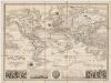
Planisphere : elémentaire et illustré indiquant la description géographique des parties connues de la terre, l'époque des grandes découvertes des navigateurs les colonies Européennes, les principaux parcours des paquebots, l'époque des départs, la durée du trajet, &c[a]
1 : 50000000 Vuillemin, A. (Alexandre), b. 1812 Fatout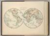
World in Hemispheres.
1 : 72000000 Johnston, W. & A.K.
Orbis Terrarum Nova Et Accuratissima Tabula. [Karte], in: Novus atlas absolutissimus, Bd. 1, S. 17.
1 Karte aus Atlas Janssonius Offizin
Hyetographische Karte der Erde
Erster Band, enthaltend in vier Abtheilungen die Erscheinungen der anorganischen Natur: 1. Meteorologie und Klimatographie. 2. Hydrologie und Hydrographie. 3. Geologie. 4. Tellurischer Magnetismus Humboldt, Alexander von Verlag von Justus Perthes
[1] Nova orbis tabula, uit: Atlas sive Descriptio terrarum orbis
Annotatie: Gedigitaliseerde versie. Amsterdam. Heiloo : Picturae (vervaardiger), 2015. tiff-bestand. Gedigitaliseerd: 07-01-2015; Origineel: Universiteitsbibliotheek Vrije Universiteit (XL.05127.-) ; Netherlands; Titelpagina ontbreekt Wit, Frederik de Amsterdam : Frederick de Wit
Mapa que demuestra el derrotero q[ue] : hizo M. Cook en 1776, 1777, 1778, y 1779 en su tercero y ultimo viaje
1 : 600000 Libreria de Copin Libreria de Copin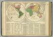
World.
1 : 110000000 Lavoisne, M.
Planiglob in Mercators Projection, zur Uebersicht der Erdfläche und der Seereisen
Hand-Atlas über alle Theile der Erde nach dem neuesten Zustande und über das Weltgebäude Stieler, Adolf bei Justus Perthes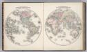
Western Hemisphere. Eastern Hemisphere.
1 : 60000000 Colton, G. Woolworth
[Planiglob in Mercators Projection, zur Uebersicht der Erdfläche und der Seereisen]
Stieler's Hand-Atlas Stieler, Adolf bei Justus Perthes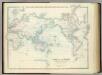
World on Mercators Projection.
1 : 72000000 Johnston, Alexander Keith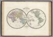
Mappemonde en deux Hemispheres.
Levasseur, E.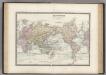
Planisphere sur la Projection de Mercator.
Levasseur, E.
Westliche Halbkugel
Hand-Atlas über alle Theile der Erde nach dem neuesten Zustande und über das Weltgebäude Stieler, Adolf bei Justus Perthes
Principal Mountains, Plateaus, & Plains of The World.
1 : 100000000 Johnson, A.J.
Facsimile: World by Mercator.
Mercator, Gerardus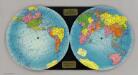
The Global Map.
1 : 50000000 Global Map Company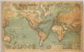
World On Mercator's Projection
1 : 15000000 Berghaus, Hermann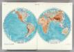
1-2. World, Physical. The World Atlas.
1 : 50000000 USSR (Union of Soviet Socialist Republics).
North America, South America, Asia, and Africa showing Minerals and Agriculture (Crops).
Hammond, C.S.
![Nova Totius Terrarum Orbis Gepgraphica Ac Hydrographica Tabula. [Karte], in: Gerardi Mercatoris et I. Hondii Newer Atlas, oder, Grosses Weltbuch, Bd. 1, S. 25.](https://images-2.georeferencer.com/images/iiif/656873317985/full/,300/0/native.jpg)

