Maps of Asia

The "time and tide" map of the Atlantic charter / [cartography] London Geographical Institute
1 : 450000 Annotatie: Bevat de 8 punten van het Atlantisch charter The London Geographical Institute, London London : Philip & Son
Vertheilung der wichtigsten physiologischen Pflanzengruppen in den Vegetationsgebieten der Erde
1 : 85000000 Engler, Adolf Wagner & Debes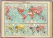
World - commerce.
1 : 92000000 John Bartholomew and Son
Welt-Karte zur Ubersicht der Luft-Stromungen und der See-Wege.
1 : 115000000 Berghaus, Hermann
Welt-Karte zur Ubersicht der Meeres-Stromungen und des Schnellverkehrs.
1 : 115000000 Berghaus, Hermann
DIE ERDE in Zwey Halbkugeln der östlichen und westlichen
země světa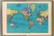
World, Mercator's projection.
1 : 64000000 Rand McNally and Company
Carte generale de toutes les costes du Monde : et les pays nouvellement decouvert
1 : 450000 Cóvens et Mortier chez Iean Cóvens et Corneille Mortier Libraires
Windkarte der Erde
Erster Band, enthaltend in vier Abtheilungen die Erscheinungen der anorganischen Natur: 1. Meteorologie und Klimatographie. 2. Hydrologie und Hydrographie. 3. Geologie. 4. Tellurischer Magnetismus Humboldt, Alexander von Verlag von Justus Perthes
The world on Mercator's projection : showing the British possessions and chief ports coloured red
Relief shown by hachures. "Supplement to the Illustrated London News, May 9, 1885." Marginal notes on the population, revenue, imports and exports value and distance from Great Britain for each colony. London : Illustrated London News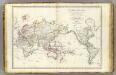
Mappe-monde.
1 : 55000000 Brue, Adrien Hubert, 1786-1832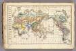
Distribution primitive du genre humain.
1 : 95000000 Vincent
Composite: Mappe-monde
1 : 27000000 Brue, Adrien Hubert, 1786-1832
India Extrema; XIX. Nova Tabula. [Karte], in: Claud. Ptolemaeus. Geographia lat. cum mappis [...], S. 413.
1 Karte aus Atlas Münster, Sebastian [und Ptolemaeus, Claudius]
Orbis Typus Universalis Iuxta Hydrographorum Traditionem [Karte], in: Claudii Ptolemei viri Alexandrini mathematice discipline philosophi doctissimi geographie opus [...], S. 230.
1 Karte aus Atlas Waldseemüller, Martin [und Ptolemaeus, Claudius] Übelin, Georg
Umrisse der Pflanzengeographie
Zweiter Band, enthaltend in vier Abtheilungen die Vertheilung der Organismen: 5. Pflanzen-Geographie, 6. Thier-Geographie, 7. Anthropographie, 8. Ethnographie Humboldt, Alexander von Verlag von Justus Perthes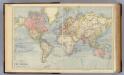
The World.
1 : 65000000 Letts, Son & Co.
Planiglob in Mercators Projection
země světa Berra, Marco bei Marco Berra
Navigation, les oceans.
1 : 67000000 Garnier, F. A., 1803-1863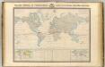
Thermometrie.
1 : 70000000 Garnier, F. A., 1803-1863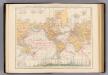
Weltverkehrs, Meeresstromungen.
1 : 90000000 Andree, Richard
Welt-Karte zur Übersicht der Meeres-Strömungen und des Schnellverkehrs
Hand-Atlas über alle Theile der Erde und über das Weltgebäude Stieler, Adolf Justus Perthes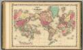
Map Of The World on Mercator's Projection.
1 : 75000000 Johnson, A.J.
Hyetographic; rain map.
1 : 71500000 Johnston, Alexander Keith, 1804-1871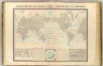
Courants atmospheriques, oceaniques.
1 : 70000000 Garnier, F. A., 1803-1863
Geographical Distribution of the Currents of Air
The physical atlas Johnston, Alexander Keith William Blackwood & Sons
I. Charte für die allgemeine Geschichte von den frühesten bekannten Zeiten bis zur Zerstörung von Troja
Entworfen von F.W. Benicken Weimar : im Verlage des L. Industrie-Comptoirs
Mappe-monde.
1 : 75000000 Lapie, M. (Pierre), 1779-1850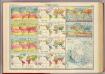
World - climate.
1 : 260000000 John Bartholomew and Son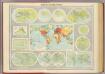
Mapping of the world.
1 : 120000000 John Bartholomew and Son
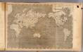
General chart, Mercator proj.
1 : 168000000 Seaman, James V.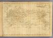
World Mercator's projection.
1 : 112000000 Arrowsmith, Aaron; Lewis, Samuel