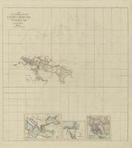
Maps of Polynesia

I. Charte für die allgemeine Geschichte von den frühesten bekannten Zeiten bis zur Zerstörung von Troja
Entworfen von F.W. Benicken Weimar : im Verlage des L. Industrie-Comptoirs
XIV. Charte für die allgemeine Geschichte vom Frieden zu Presburg bis auf den IIten Frieden zu Paris : d.i. von 1806 bis 1815 n. Christus
Entworfen von F.W. Benicken Weimar : im Verlage des L. Industrie-Comptoirs
XII. Charte für die allgemeine Geschichte vom Anfange der österr. Erbfolge-Krieges bis auf den Tod Friedrichs des Zweiten : d.i. von 1740 bis 1786 n. Christus
Entworfen von F.W. Benicken in Stein grav. von A. Falger Weimar : im Verlage des L. Industrie-Comptoirs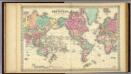
Colton's Map Of The World On Mercator's Projection.
1 : 65000000 Colton, G.W.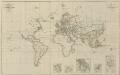
IX. Charte für die allgemeine Geschichte von Carl V. bis auf den Anfang des XXX-jährigen Krieges : d.i. von 1519 bis 1618 n. Christus
Entworfen von F.W. Benicken A. Falger gr. Weimar : im Verlage des L. Industrie-Comptoirs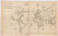
Carte generale de toutes les costes du Monde : et les pays nouvellement decouvert
1 : 450000 Cóvens et Mortier chez Iean Cóvens et Corneille Mortier Libraires
Typus Orbis A Ptol. Descriptus [Karte], in: Claud. Ptolemaeus. Geographia lat. cum mappis [...], S. 251.
1 Karte aus Atlas Münster, Sebastian [und Ptolemaeus, Claudius]
Hyetographische Karte der Erde.
1 : 100000000 Berghaus, Heinrich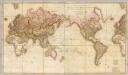
Chart of the world upon Mercator's projection.
1 : 20000000 Cary, John, ca. 1754-1835
Planisphère
1 : 57000000 Izarny-Gargas; France. Service géographique de l'armée [Paris] :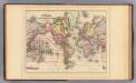
World Mercator proj.
1 : 97000000 Mitchell, Samuel Augustus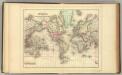
World Mercator proj.
1 : 97000000 Mitchell, Samuel Augustus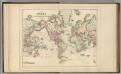
World Mercator proj.
1 : 97000000 Mitchell, Samuel Augustus Jr.
World Mercator proj.
1 : 100000000 Mitchell, Samuel Augustus
World.
1 : 95000000 Mitchell, Samuel Augustus
World Mercator proj.
1 : 100000000 Mitchell, Samuel Augustus
Map Of The World On The Mercator Projection.
1 : 100000000 Mitchell, Samuel Augustus
The world, on Mercator's projection
1 : 74000000 Burr, David H., 1803-1875 Published by J. Haven, 86 State St.
Allgemeine Ornitho- und Erpetologische Erdkarte.
1 : 130000000 Berghaus, Heinrich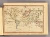
The World, Mercator's projection.
1 : 255000000 Fenner, Rest.
Routes par lesquelles les richesses metalliques.
1 : 160000000 Humboldt, Alexander von, 1769-1859
Chart of the world.
1 : 95000000 Bowen, Emanuel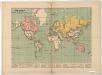
The world on Mercator's projection : showing the British possessions and chief ports coloured red
Relief shown by hachures. "Supplement to the Illustrated London News, May 9, 1885." Marginal notes on the population, revenue, imports and exports value and distance from Great Britain for each colony. London : Illustrated London News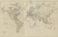
XV. Charte für die allgemeine Geschichte vom zweiter Pariser Frieden 1815 bis zu Ende des Jahres 1822 : d.i. von 1815 bis Ende 1822 n. Chr
Entworfen von F.W. Benicken A. Falger gr. Weimar : im Verlage des L. Industrie-Comptoirs
Nova totius terrarum orbis geographica ac hydrographica tabula / autore N.I. Piscator
1 : 50000000 Annotatie: Origineel is Blad 1 in atlas factice; Met talrijke kostuumfiguren in kaartrand Visscher, Claes Jansz. [Amsterdam : C.J. Visscher excudebat]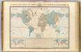
Systeme magnetique terrestre.
1 : 70000000 Garnier, F. A., 1803-1863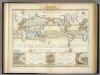
Windkarte der Erde.
1 : 100000000 Berghaus, Heinrich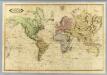
World.
1 : 51000000 Lizars, Daniel
Windkarte der Erde
Erster Band, enthaltend in vier Abtheilungen die Erscheinungen der anorganischen Natur: 1. Meteorologie und Klimatographie. 2. Hydrologie und Hydrographie. 3. Geologie. 4. Tellurischer Magnetismus Humboldt, Alexander von Verlag von Justus Perthes