Maps of Götaland

[Daenemark mit Schleswig, Holstein, und Lauenburg; Island u. Fär-Öer]
Schul-Atlas über alle Theile der Erde nach dem neuesten Zustande, und über das Weltgebäude Stieler, Adolf Justus Perthes
Danemark vizt Jutland, Zeland, Sleswick, Holstein.
from A new systeme of the mathematicks: containing I. Arithmetick, as well natural and decimal, as in species, or the principles of algebra. II. Practical geometry, together with the first six books of Euclid's Elements, as also the eleventh and twelfth, symbo
Denmark.
from A system of geography, or, A new & accurate description of the earth in all its empires, kingdoms and states : illustrated with history and topography, and maps of every country : fairly engraven on copper, according to the latest discoveries and corrections / by Herman Moll.
Daniæ, Frisiæ, Groningæ et Orientalis Frisiæ littora
1 Karte : Kupferdruck ; 48 x 56 cm Renard apud L. Renard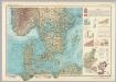
Southern Scandanavia. Pergamon World Atlas.
1 : 2500000 Polish Army Topography Service
Daniae Regni Typus. [Karte], in: Theatrum orbis terrarum, S. 56.
1 Karte aus Atlas Ortelius, Abraham
Danemarc. Europe 8.
1 : 1641836 Vandermaelen, Philippe, 1795-1869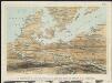
Stannard & Son's, panoramic birds-eye view, of Berlin & its defences, the principal Prussian ports on the Baltic, with Denmark and Schleswig Holstein
1 : 1
[Dänemark und Süd-Schweden]
Neuer Handatlas über alle Theile der Erde Kiepert, Heinrich Verlag von Dietrich Reimer
Carte réduite de la mer Baltique, 1
1 Blatt : 73 x 60 cm Froullé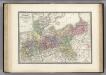
Prussienne.
1 : 2400000 Levasseur, E.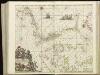
[124][127] Daniae, Frisiae, Groningae et Orientalis Frisiae littora, uit: Atlas sive Descriptio terrarum orbis
Annotatie: Gedigitaliseerde versie. Amsterdam. Heiloo : Picturae (vervaardiger), 2015. tiff-bestand. Gedigitaliseerd: 07-01-2015; Origineel: Universiteitsbibliotheek Vrije Universiteit (XL.05127.-) ; Netherlands; Titelpagina ontbreekt Wit, Frederik de Amsterdam : Frederick de Wit
Atlas für Handel und Industrie: Für Kaufleute, Fabrikante u. Gewerbetreibende, Handlungs- u. Gewerbe-Schulen

[Königreich Daenemark]
Neuester Schul-Atlas Walch, Johann im Verlag bei Joh. Walch
[Dänemark, Island, die Far-Oer]
Plastischer Schul-Atlas über alle Theile der Erde : in 24 Karten Woldermann, G Verlag von P. Eckerlein
[Daenemark mit Schleswig, Holstein und Lauenburg auch Südl. Theil v. Schweden]
Hand-Atlas über alle Theile der Erde nach dem neuesten Zustande und über das Weltgebäude Stieler, Adolf bei Justus Perthes
Daenemark mit Schleswig, Holstein und Lauenburg auch Südl. Theil v. Schweden
Hand-Atlas über alle Theile der Erde nach dem neuesten Zustande und über das Weltgebäude Stieler, Adolf bei Justus Perthes
Daniae Regni Typus. [Karte], in: Theatrum orbis terrarum, S. 204.
1 Karte aus Atlas Ortelius, Abraham Vrients, Jan Baptista
Denmark with Northwest portion of the German Empire
1 : 1332000 Johnston, Alexander Keith
Dania Regnum [Karte], in: Novus Atlas, das ist, Weltbeschreibung, Bd. 1, S. 33.
1 Karte aus Atlas Blaeu, Joan Blaeu, Willem Janszoon
Denmark with Northwest portion of the German Empire
1 : 1332000 Johnston, Alexander Keith
[Neueste Karte von Dänemark mit Holstein und Lauenburg, Mecklenburg Schwerin Strelitz, Oldenburg, die freien Städte Hamburg, Lübeck und Bremen]
Grosser Hand-Atlas über alle Theile der Erde in 170 Karten Meyer, J. Verlag des Bibliographischen Instituts
Daenemark
Allgemeiner Atlas [Walch, Johannes] im Verlag bei Johannes Walch
[Velká Británie a Irsko]
Velká Británie Lotter, Tobias Conrad Lotter, Matthäus Albrecht
Denmark with Northwest portion of the German Empire
1 : 1332000 Johnston, W. & A.K.
[Daenemark mit Holstein u. Lauenburg]
Stieler's Hand-Atlas Stieler, Adolf bei Justus Perthes
Daenemark mit Holstein und Lauenburg auch südlicher Theil von Schweden
1 : 3200000 Dánsko
Daenemark
E. von Sydow's Schul-Atlas in sechs und dreissig Karten Sydow, Emil von bei Justus Perthes
[Daenemark mit Holstein und Lauenburg; auch Island und Fär-Öer]
Schul-Atlas über alle Theile der Erde nach dem neuesten Zustande, und über das Weltgebäude Stieler, Adolf bei Justus Perthes
![[Daenemark mit Schleswig, Holstein, und Lauenburg; Island u. Fär-Öer]](https://images-2.georeferencer.com/images/iiif/052504587294/full/,300/0/native.jpg)

