Maps of Götaland

Carte réduite de la mer Baltique, 1
1 Blatt : 73 x 60 cm Froullé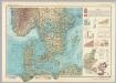
Southern Scandanavia. Pergamon World Atlas.
1 : 2500000 Polish Army Topography Service
[Dänemark und Süd-Schweden]
Neuer Handatlas über alle Theile der Erde Kiepert, Heinrich Verlag von Dietrich Reimer
Denmark.
from A system of geography, or, A new & accurate description of the earth in all its empires, kingdoms and states : illustrated with history and topography, and maps of every country : fairly engraven on copper, according to the latest discoveries and corrections / by Herman Moll.
Daniae Regni Typus. [Karte], in: Theatrum orbis terrarum, S. 56.
1 Karte aus Atlas Ortelius, Abraham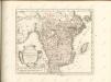

[Dänemark, Island, die Far-Oer]
Plastischer Schul-Atlas über alle Theile der Erde : in 24 Karten Woldermann, G Verlag von P. Eckerlein
Daniae Regni Typvs
1 : 2100000 Mollova mapová sbírka Ortelius, Abraham Diesthem, Aegidius Copenius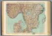
63-64. Svezia, Norvegia meridionale.
1 : 1500000 Touring club italiano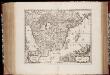
Gothia
1 : 1500000 Annotatie: Rechtsboven: XXII; Origineel is Blad 143 in atlas factice; Annotatie geografische gegevens: Schaalstokken op de kaart: Milliaria Westrogothica quorum 8 1/2 uni grad. respondent, en: Milliaria Ostrogothia quorum 12 uni grad. respondent [Amsterdam etc. : apud Janssonio-Waesbergios et Mosem Pitt]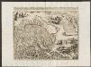
Gothia [Karte], in: Theatrum orbis terrarum, sive, Atlas novus, Bd. 1, S. 56.
1 Karte aus Atlas Blaeu, Joan Blaeu, Willem Janszoon
Gothia [Karte], in: Le théâtre du monde, ou, Nouvel atlas contenant les chartes et descriptions de tous les païs de la terre, Bd. 1, S. 58.
1 Karte aus Atlas Blaeu, Willem Janszoon und Blaeu, Joan Blaeu, Willem Janszoon
Gothia [Karte], in: Novus atlas absolutissimus, Bd. 1, S. 54.
1 Karte aus Atlas Janssonius Offizin
Gothia [Karte], in: Novus Atlas, das ist, Weltbeschreibung, Bd. 1, S. 42.
1 Karte aus Atlas Blaeu, Joan Blaeu, Willem Janszoon
Postkarte von Schweden Ansich, von Gothland und von Norwegen
Gotland (Švédsko) Ponheimer, Kilian im von Reillyschen Landkarten und Kunstwerke Verschleiss Komptoir
GOTHIA.
[Amsterdam : Joan Blaeu]
Südliches Schweden
Grosser Hand-Atlas über alle Theile der Erde in 170 Karten Meyer, J. Verlag des Bibliographischen Instituts
Turkart over Hallingskarvet
Statens Kartverk
Südskandinavien
1 : 2500000 Oslo (Norsko) Justus Perthes
Südliches Schweden

[Daenemark mit Schleswig, Holstein, und Lauenburg; Island u. Fär-Öer]
Schul-Atlas über alle Theile der Erde nach dem neuesten Zustande, und über das Weltgebäude Stieler, Adolf Justus Perthes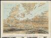
Stannard & Son's, panoramic birds-eye view, of Berlin & its defences, the principal Prussian ports on the Baltic, with Denmark and Schleswig Holstein
1 : 1
Danemarc. Europe 8.
1 : 1641836 Vandermaelen, Philippe, 1795-1869
Danemark vizt Jutland, Zeland, Sleswick, Holstein.
from A new systeme of the mathematicks: containing I. Arithmetick, as well natural and decimal, as in species, or the principles of algebra. II. Practical geometry, together with the first six books of Euclid's Elements, as also the eleventh and twelfth, symbo
Denmark.
1 : 2400000 Bowen, Emanuel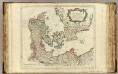
Danemarck.
1 : 1180000 Robert de Vaugondy, Gilles, 1688-1766
Jernvägs, Diligens, Post och Telegraf Karta öfver Sverige
Gotland (Švédsko : ostrov) Amundson, Albert Norstedt & Söners

[Daenemark mit Holstein u. Lauenburg]
Stieler's Hand-Atlas Stieler, Adolf bei Justus Perthes


