Maps of Götaland

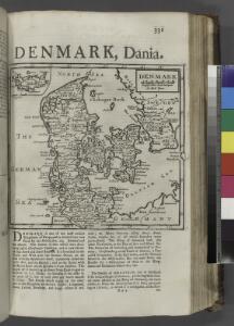
Denmark.
from A system of geography, or, A new & accurate description of the earth in all its empires, kingdoms and states : illustrated with history and topography, and maps of every country : fairly engraven on copper, according to the latest discoveries and corrections / by Herman Moll.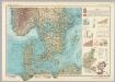
Southern Scandanavia. Pergamon World Atlas.
1 : 2500000 Polish Army Topography Service
Feuille 17 (C III), uit: Carte géologique internationale de l'Europe : la carte, votée au congrès géologique international de Bologne en 1881, est exécutée conformément aux décisions d'une commission internationale, avec le concours des gouvernements, sous le dir. de M.M. Beyrich et Hauchecorne
Annotatie: Blad 48 gamme des couleurs; blad 49: bladwijzer en titelblad Heinrich Ernst Beyrich 1815-1896; Wi. Hauchecorne Berlin : Reimer / (Berlin: Institut lithographique)
[Daenemark mit Schleswig, Holstein, und Lauenburg; Island u. Fär-Öer]
Schul-Atlas über alle Theile der Erde nach dem neuesten Zustande, und über das Weltgebäude Stieler, Adolf Justus Perthes
Carte réduite de la mer Baltique, 1
1 Blatt : 73 x 60 cm Froullé
Danemarc. Europe 8.
1 : 1641836 Vandermaelen, Philippe, 1795-1869
[Dänemark und Süd-Schweden]
Neuer Handatlas über alle Theile der Erde Kiepert, Heinrich Verlag von Dietrich Reimer
Postkarte von Schweden Ansich, von Gothland und von Norwegen
Gotland (Švédsko) Ponheimer, Kilian im von Reillyschen Landkarten und Kunstwerke Verschleiss Komptoir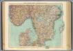
63-64. Svezia, Norvegia meridionale.
1 : 1500000 Touring club italiano
correct chart of the North Sea, with the adjacent coasts of Britain, Holland, Germany, Denmark, Norway, the islands of Orkney and Shetland, the entrance to the Sound and the Baltic Sea
1 : 3400000
Southern Scandinavia & Denmark.
1 : 2000000 John Bartholomew and Son
Südskandinavien
1 : 2500000 Oslo (Norsko) Justus Perthes
Danemark vizt Jutland, Zeland, Sleswick, Holstein.
from A new systeme of the mathematicks: containing I. Arithmetick, as well natural and decimal, as in species, or the principles of algebra. II. Practical geometry, together with the first six books of Euclid's Elements, as also the eleventh and twelfth, symbo
[Dänemark, Island, die Far-Oer]
Plastischer Schul-Atlas über alle Theile der Erde : in 24 Karten Woldermann, G Verlag von P. Eckerlein
Denmark, pt. of Norway.
1 : 1770000 Society for the Diffusion of Useful Knowledge (Great Britain)
Daniae Regni Typus. [Karte], in: Theatrum orbis terrarum, S. 56.
1 Karte aus Atlas Ortelius, Abraham
Atlas für Handel und Industrie: Für Kaufleute, Fabrikante u. Gewerbetreibende, Handlungs- u. Gewerbe-Schulen

Denmark, S. Norway.
1 : 1774080 Letts, Son & Co.
Spesielle kart 73: Dialektformers udbredelse i Kristianssands stift
1 : 2000000 A. B. Larsen Norges Geografiske Opmaaling

Denmark and part of Norway (Denmark, Norge)
1 : 2000000 Dánsko Walker, C. Baldwin & Cradock
Denmark.
1 : 2400000 Bowen, Emanuel
[Königreich Daenemark]
Neuester Schul-Atlas Walch, Johann im Verlag bei Joh. Walch
[Daenemark mit Schleswig, Holstein und Lauenburg auch Südl. Theil v. Schweden]
Hand-Atlas über alle Theile der Erde nach dem neuesten Zustande und über das Weltgebäude Stieler, Adolf bei Justus Perthes
Daenemark mit Schleswig, Holstein und Lauenburg auch Südl. Theil v. Schweden
Hand-Atlas über alle Theile der Erde nach dem neuesten Zustande und über das Weltgebäude Stieler, Adolf bei Justus Perthes
Dania Regnum [Karte], in: Novus Atlas, das ist, Weltbeschreibung, Bd. 1, S. 33.
1 Karte aus Atlas Blaeu, Joan Blaeu, Willem Janszoon
Daenemark
Allgemeiner Atlas [Walch, Johannes] im Verlag bei Johannes Walch
Daniae Regni Typvs
1 : 2100000 Mollova mapová sbírka Ortelius, Abraham Diesthem, Aegidius Copenius
Die britischen Inseln
Velká Británie Wyld, James Kitchin, Thomas