Maps of Lower Saxony

Daniæ, Frisiæ, Groningæ et Orientalis Frisiæ littora
1 Karte : Kupferdruck ; 48 x 56 cm Renard apud L. Renard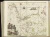
[124][127] Daniae, Frisiae, Groningae et Orientalis Frisiae littora, uit: Atlas sive Descriptio terrarum orbis
Annotatie: Gedigitaliseerde versie. Amsterdam. Heiloo : Picturae (vervaardiger), 2015. tiff-bestand. Gedigitaliseerd: 07-01-2015; Origineel: Universiteitsbibliotheek Vrije Universiteit (XL.05127.-) ; Netherlands; Titelpagina ontbreekt Wit, Frederik de Amsterdam : Frederick de Wit
Danemark vizt Jutland, Zeland, Sleswick, Holstein.
from A new systeme of the mathematicks: containing I. Arithmetick, as well natural and decimal, as in species, or the principles of algebra. II. Practical geometry, together with the first six books of Euclid's Elements, as also the eleventh and twelfth, symbo
[Daenemark mit Schleswig, Holstein, und Lauenburg; Island u. Fär-Öer]
Schul-Atlas über alle Theile der Erde nach dem neuesten Zustande, und über das Weltgebäude Stieler, Adolf Justus Perthes
Denmark with Northwest portion of the German Empire
1 : 1332000 Johnston, Alexander Keith
Denmark with Northwest portion of the German Empire
1 : 1332000 Johnston, Alexander Keith
Denmark with Northwest portion of the German Empire
1 : 1332000 Johnston, W. & A.K.
[Velká Británie a Irsko]
Velká Británie Lotter, Tobias Conrad Lotter, Matthäus Albrecht
Skizze zur Orientirung ϋber den Feldzug 1814

[Das Deutsches Reich, Blatt 1]
Adolf Stieler's Handatlas über alle Theile der Erde und über das Weltgebäude Stieler, Adolf Justus Perthes
Carte des trois royaumes d'Angleterre d'Ècosse et d'Irlande
Velká Británie Raffelsperger, Franz Kitchin, Thomas
Magna Britannia complectens Angliae, Scotiae et Hiberniae regn. in suas prov. et comitat.
Velká Británie Seutter, Matthäus Vilém Oranžský per Homannum
Konigreich Grossbrittanien und Irland
Velká Británie Raffelsperger, Franz Kitchin, Thomas
Denmark, Hanover, Brunswick, Mecklenburg, Oldenburg.
1 : 1332000 Johnston, Alexander Keith, 1804-1871
Daniae Regni Typus. [Karte], in: Theatrum orbis terrarum, S. 204.
1 Karte aus Atlas Ortelius, Abraham Vrients, Jan Baptista
Gross-Britanien und Irland
Velká Británie Raffelsperger, Franz Kitchin, Thomas Franz Raffelsperger
Nordwestl. Deutschland und Daenemark
[Allgemeiner Atlas über alle Theile der Erde in 29 Blättern] Ziegler, Jakob Melchior Top. Anstalt v. J. Wurster u. Comp.
[Daenemark mit Schleswig, Holstein und Lauenburg auch Südl. Theil v. Schweden]
Hand-Atlas über alle Theile der Erde nach dem neuesten Zustande und über das Weltgebäude Stieler, Adolf bei Justus Perthes
[Königreich Daenemark]
Neuester Schul-Atlas Walch, Johann im Verlag bei Joh. Walch
Die britischen Inseln
Velká Británie Wyld, James Kitchin, Thomas
Magna Britannia et Hibernia
Velká Británie Walch, Johann Kitchin, Thomas J. Walch
Danemarc. Europe 8.
1 : 1641836 Vandermaelen, Philippe, 1795-1869
Denmark.
1 : 1837440 Tallis, J. & F.
Denmark.
1 : 1250000 Teesdale, Henry
Daenemark mit Schleswig, Holstein und Lauenburg auch Südl. Theil v. Schweden
Hand-Atlas über alle Theile der Erde nach dem neuesten Zustande und über das Weltgebäude Stieler, Adolf bei Justus Perthes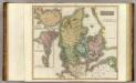
Denmark, Iceland, Feroe Islands.
1 : 960000 Thomson, John
[Neueste Karte von Dänemark mit Holstein und Lauenburg, Mecklenburg Schwerin Strelitz, Oldenburg, die freien Städte Hamburg, Lübeck und Bremen]
Grosser Hand-Atlas über alle Theile der Erde in 170 Karten Meyer, J. Verlag des Bibliographischen Instituts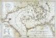
Carte de la mer de Dannemark et des entrées dans la mer baltique
1 Karte : Kupferdruck ; 59 x 85 cm s.n.
Denmark, S. Norway.
1 : 1774080 Letts, Son & Co.


