Maps of Saxony

Geographische Abbildvng des gantzen Umfangs der Marggrafschft Meissen, wie solche grösten Theils unter Churf. Saechs. sowohl als anderer Reichsfürsten und Reichs-Grafen Lands Hoheit heutiger Zeit beherrschet wird
1 : 420000 Míšeň-oblast (Německo) Zürner, Adam Friedrich von Homaennischen Erben
Operationen der Preussischen Haupt-Armee, der Armee des Feldmarschalls Daun und der Reichs-Armee vom 4ten bis 23ten November 1759

Marchionatus Misniae primaria elector. Saxoniae provincia in circlos suos subdivisus accedit ditionum regionumq. circumjacentium magna pars
1 : 440000 Míšeň-oblast (Německo) Seutter, Matthäus Lotter, Tobias Conrad Matth. Seutter
Marchionatus Misniae primaria Elector: Saxoniae Provincia
1 : 420000 Mollova mapová sbírka Seutter, Matthäus Seutter, Matthäus
Saxoniae superioris
1 : 500000 Sasko (Německo) Lotter, Tobias Conrad per Tob. Conradum Lotter

Marchionatus Misniae, in qua sunt territorium Misniense, Lipsiense, Voitlandiae, Osterlandiae, Ertzgeburgi, et Dominium Naumburgense, Mersoburgense, Episcopatus Hallensis
1 : 450000 per J. Danckerts Amsterdam : J. Danckerts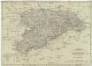
Königreich Sachsen
1 : 632000 Sasko (Německo) Mollo, Tranquillo T. Mollo
Marquisat de Misnie premiere Province de la Saxe
1 : 430000 Mollova mapová sbírka Le Rouge, Georges-Louis Le Rouge, Georges-Louis
Marchionatus Misniae una cum Voitlandia. [Karte], in: Novus atlas absolutissimus, Bd. 2, S. 69.
1 Karte aus Atlas Janssonius Offizin
Geographische Abbildung des gantzen Umfangs der Marggrafschaft Meissen
1 : 420000 Mollova mapová sbírka Homann, Johann Baptist Homann, Johann Baptista - dědici
Ducatus Saxoniae Superioris :
1 : 560000 Mollova mapová sbírka Zollmann, Friedrich Homann, Johann Baptista - dědici
Marchionatus Misniae una cum Voitlandia
1 : 530000 Mollova mapová sbírka Örnehufvud, Olof Hansson Schenk, Peter I
Circulus Saxoniae Superioris
1 : 590000 Mollova mapová sbírka Homann, Johann Baptist Homann, Johann Baptista
Haupt-Kriegs-Plan in Sachsen und den angränzenden Ländern
Sasko (Německo) Verlage des Thadé Weigl am Graben
Saxonia Svperior
1 : 900000 Mollova mapová sbírka Weigel, Christoph Weigel, Christoph I.
Misnia marchionatvs
1 : 450000 Míšeň-oblast (Německo) Blaeu, Joan Jo. Blaeu
Misnia Marchionatus
Mollova mapová sbírka Blaeu, Joan Blaeu, Joan I.
Des Ober Saechsischen Creises Südlicher theil mit abgetheilten Provintzen
1 : 2100000 Mollova mapová sbírka Weigel, Christoph Weigel, Christoph I.
La Saxe Contenant les Routtes et les Postes
1 : 490000 Mollova mapová sbírka Le Rouge, Georges-Louis Le Rouge, Georges-Louis
Saxoniae Superioris, Praesertim Electoralis Circulus
1 : 500000 Mollova mapová sbírka Lotter, Tobias Conrad Lotter, Tobias Conrad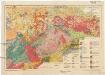
Geologische Übersichtskarte von Sachsen i. M. 1:400 000
1 : 400000 Sasko (Německo) Kossmat, Franz Pietzsch, Kurt Geologischen Landesamt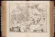
Misnia marchionatvs = Meissen / Jo. Blaeu excu
1 : 440000 titelvariant: Meissen; Annotatie: Origineel is Blad 100 in atlas factice; Annotatie geografische gegevens: Schaalvermelding op kaart: 4 Milliaria Germanica communia; Kaart toont Markgrafschaft Meissen met de steden Naumburg, Leipzig, Meißen en Dresden. Joan Blaeu 1597/98-1673 [Amsterdam : Joan Blaeu]
Saxoniæ superioris circulus
1 Karte : Kupferdruck ; 48 x 56 cm Seutter Matthäus Seutter
MISNIA | MARCHIONATVS | Meissen.
Jo. Blaeu Excu.
Misniae et Lvsatiae tabvla
1 Karte : Kupferdruck ; 28 x 20 cm Scultetus; Ortelius s.n.
Misniae et Lvsatiae tabvla
1 Karte : Kupferdruck ; 28 x 20 cm Scultetus; Ortelius s.n.
Operations-Karte zum Feldzuge des Jahres 1761 in Sachsen
1 : 600000
Strassenkarte des Koenigreiches Boehmen


