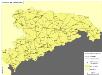
Maps of Sachsen

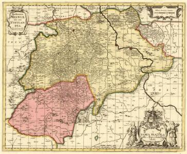
Marchionatus Misniae una cum Voitlandia
1 : 530000 Mollova mapová sbírka Örnehufvud, Olof Hansson Schenk, Peter I
Misnia marchionatvs
1 : 450000 Míšeň-oblast (Německo) Blaeu, Joan Jo. Blaeu
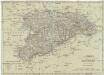
Marquisat de Misnie premiere Province de la Saxe
1 : 430000 Mollova mapová sbírka Le Rouge, Georges-Louis Le Rouge, Georges-Louis
Misnia Marchionatus
Mollova mapová sbírka Blaeu, Joan Blaeu, Joan I.
Marchionatus Misniae, in qua sunt territorium Misniense, Lipsiense, Voitlandiae, Osterlandiae, Ertzgeburgi, et Dominium Naumburgense, Mersoburgense, Episcopatus Hallensis
1 : 450000 per J. Danckerts Amsterdam : J. Danckerts
Marchionatus Misniae primaria Elector: Saxoniae Provincia
1 : 420000 Mollova mapová sbírka Seutter, Matthäus Seutter, Matthäus
Marchionatus Misniae primaria elector. Saxoniae provincia in circlos suos subdivisus accedit ditionum regionumq. circumjacentium magna pars
1 : 440000 Míšeň-oblast (Německo) Seutter, Matthäus Lotter, Tobias Conrad Matth. Seutter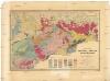
Geognostische General-Charte des Königreichs Sachsen und der angrenzenden Länder-Abtheilungen
1 : 365000 Sasko (Německo) Naumann, Carl Friedrich Williard, J. Königl. Bergakademie
MISNIA | MARCHIONATVS | Meissen.
Jo. Blaeu Excu.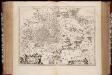
Misnia marchionatvs = Meissen / Jo. Blaeu excu
1 : 440000 titelvariant: Meissen; Annotatie: Origineel is Blad 100 in atlas factice; Annotatie geografische gegevens: Schaalvermelding op kaart: 4 Milliaria Germanica communia; Kaart toont Markgrafschaft Meissen met de steden Naumburg, Leipzig, Meißen en Dresden. Joan Blaeu 1597/98-1673 [Amsterdam : Joan Blaeu]
Marchionatus Misniae
1 : 420000 Mollova mapová sbírka Wit, Frederik de Covens, Johannes I
Marchionatus Misniae una cum Voitlandia. [Karte], in: Novus atlas absolutissimus, Bd. 2, S. 69.
1 Karte aus Atlas Janssonius Offizin
Marchionatus Misniae in qua sunt Territorium Misniense, Lipsiense, Voitlandiae, Osterlandiae, Ertzgeburgi et Dominium Naumburgense Mersoburgense. Episcopatus Hallensis
1 : 380000 Mollova mapová sbírka Danckerts, Justus Danckerts, Justus
Dislokation der preuss. Armee in Sachsen und der gegenüber stehenden österreichischen und Reichs Armee in den Winterquartieren 1760/1
Königreich Sachsen
1 : 632000 Sasko (Německo) Mollo, Tranquillo T. Mollo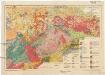
Geologische Übersichtskarte von Sachsen i. M. 1:400 000
1 : 400000 Sasko (Německo) Kossmat, Franz Pietzsch, Kurt Geologischen Landesamt
Misniae et Lvsatiae tabvla
1 Karte : Kupferdruck ; 28 x 20 cm Scultetus; Ortelius s.n.
Misniae et Lvsatiae tabvla
1 Karte : Kupferdruck ; 28 x 20 cm Scultetus; Ortelius s.n.
[Sasko]
1 : 290000 Drážďany (Německo)
Des Ober Saechsischen Creises Südlicher theil mit abgetheilten Provintzen
1 : 2100000 Mollova mapová sbírka Weigel, Christoph Weigel, Christoph I.
Königreich Sachsen
Sasko (Německo) Berra, Marco Marco Berra
Geographische Abbildvng des gantzen Umfangs der Marggrafschft Meissen, wie solche grösten Theils unter Churf. Saechs. sowohl als anderer Reichsfürsten und Reichs-Grafen Lands Hoheit heutiger Zeit beherrschet wird
1 : 420000 Míšeň-oblast (Německo) Zürner, Adam Friedrich von Homaennischen Erben
Sachsen

Das Königreich Sachsen
1 : 320000 Sasko (Německo) Gräf, C. Armann. C. Geographisches Institut
Das Königreich Sachsen
Grosser Hand-Atlas über alle Theile der Erde in 170 Karten Meyer, J. Verlag des Bibliographischen Instituts
Das Koenigreich Sachsen
1 : 375000 Drážďany (Německo) Weiland, Karl Ferdinand Höckner, C. Verlage des geogr. Instituts
Das Koenigreich Sachsen
1 : 375000 Drážďany (Německo) Weiland, Karl Ferdinand Höckner, C. im Verlage des geogr. Instituts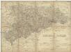
Das Königreich Sachsen
1 : 375000 Sasko (Německo) Gräf, C.
Geographische Abbildung des gantzen Umfangs der Marggrafschaft Meissen
1 : 420000 Mollova mapová sbírka Homann, Johann Baptist Homann, Johann Baptista - dědici