Maps of Thüringen

Saxonia Svperior
1 : 900000 Mollova mapová sbírka Weigel, Christoph Weigel, Christoph I.
1:500,000 Europe (Air) G.S.G.S. No. 4072, Leipzig
Sheet NE50-10 from the map series: 1:500,000 Europe (Air) G.S.G.S. No. 4072.
Saxoniæ superioris circulus
1 Karte : Kupferdruck ; 48 x 56 cm Seutter Matthäus Seutter
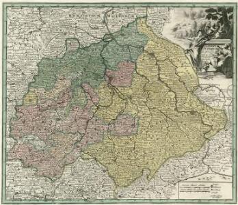
Saxoniae Superioris, Praesertim Electoralis Circulus
1 : 500000 Mollova mapová sbírka Lotter, Tobias Conrad Lotter, Tobias Conrad
La Saxe Contenant les Routtes et les Postes
1 : 490000 Mollova mapová sbírka Le Rouge, Georges-Louis Le Rouge, Georges-Louis
Sachsen, Thüringen und Benachbarte Laender
Stieler's Hand-Atlas Stieler, Adolf bei Justus Perthes
Ducatus Saxoniae Superioris :
1 : 560000 Mollova mapová sbírka Zollmann, Friedrich Homann, Johann Baptista - dědici
Circuli Saxoniae Superior Pars Meridionalis
1 : 600000 Mollova mapová sbírka Wit, Frederik de Ottens, Josua
Circuli Saxoniae Superioris Pars Meridionalis
1 : 600000 Mollova mapová sbírka Wit, Frederik de
Saxoniae Superioris praesertim electoralis circulus, cum adjacentibus ducatibus et provinciis simulque diligentissime annotatis postarum cursus et stationes mappa geographica
1 : 500000 recens et accurata delineata per Tob. Conradum Lotter Aug. Vindel. : per Tob. Conradum Lotter
[42][42]Circuli Saxoniae Superioris pars meridionalis ..., uit: Atlas sive Descriptio terrarum orbis
Annotatie: Gedigitaliseerde versie. Amsterdam. Heiloo : Picturae (vervaardiger), 2015. tiff-bestand. Gedigitaliseerd: 07-01-2015; Origineel: Universiteitsbibliotheek Vrije Universiteit (XL.05127.-) ; Netherlands; Titelpagina ontbreekt Wit, Frederik de Amsterdam : Frederick de Wit
Sachsen, Thuringen und benachbarte Lander.
1 : 925000 Vogel, C.
Sachsen, Thüringen und Benachbarte Länder
Handatlas über alle Theile der Erde und über das Weltgebäude Stieler, Adolf Justus Perthes
Thuringen u. Sachsen.
1 : 600000 Gutbier, Ludwig von
[Sasko]
Sasko (Německo) Jacob, Johann Gotthelff
Sachsen, Thueringen und Benachbarte Länder
Hand-Atlas über alle Theile der Erde und über das Weltgebäude Stieler, Adolf Justus Perthes

Sachsen, Thüringen und Benachbarte Laender
Hand-Atlas über alle Theile der Erde nach dem neuesten Zustande und über das Weltgebäude Stieler, Adolf bei Justus Perthes
Sachsen, Thüringen und Benachbarte Länder
Adolf Stieler's Handatlas über alle Theile der Erde und über das Weltgebäude Stieler, Adolf Justus Perthes
Haute Saxe meridionale.
1 : 600000 Robert de Vaugondy, Gilles, 1688-1766
Sachsen die Staaten in Thüringen und benachbartex Länder

Sachsen, Thueringen und benachbarte Länder
Hand-Atlas über alle Theile der Erde nach dem neuesten Zustande und über das Weltgebäude Stieler, Adolf bei Justus Perthes
CIRCULI SAXONIAE SUPERIORI[S]
1 : 620000 Anhaltsko (Německo) Wit, Frederick de F. de Wit
Circuli Saxoniae superiori[s] pars meridionalis
1 : 620000 Anhaltsko (Německo) Danckerts, Justus per Iustinum Danckerts
Circuli Saxoniae superiori[s] pars meridionalis
1 : 600000 1 Karte : Kupferdruck ; 47 x 55 cm Danckerts, Justus [Danckerts]
Saxoniae superioris
1 : 500000 Sasko (Německo) Lotter, Tobias Conrad T.C. Lotter
Saxoniae superioris
1 : 500000 Sasko (Německo) Lotter, Tobias Conrad T. C. Lotter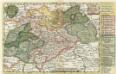
Neue Reise Charte durch Sachsen zu beqvemen Gebrauch
1 : 1500000 Mollova mapová sbírka Schreiber, Johann Georg Schreiber, Johann Georg
Neueste Charte vom Königreich Sachsen
1 : 683000 Sasko (Německo) Walch, Johann J. Walch