Maps of Saxony

Marchionatus Misniae una cum Voitlandia. [Karte], in: Novus atlas absolutissimus, Bd. 2, S. 69.
1 Karte aus Atlas Janssonius Offizin
Saxoniae superioris
1 : 500000 Sasko (Německo) Lotter, Tobias Conrad per Tob. Conradum Lotter
Dislokation der preuss. Armee in Sachsen und der gegenüber stehenden österreichischen und Reichs Armee in den Winterquartieren 1760/1

Sachsen, Thuringen und benachbarte Lander.
1 : 925000 Vogel, C.
Sachsen, Thüringen und Benachbarte Länder
Handatlas über alle Theile der Erde und über das Weltgebäude Stieler, Adolf Justus Perthes
Sachsen, Thueringen und Benachbarte Länder
Hand-Atlas über alle Theile der Erde und über das Weltgebäude Stieler, Adolf Justus Perthes
Sachsen, Thüringen und Benachbarte Länder
Adolf Stieler's Handatlas über alle Theile der Erde und über das Weltgebäude Stieler, Adolf Justus Perthes
Sachsen, Thüringen und Benachbarte Laender
Stieler's Hand-Atlas Stieler, Adolf bei Justus Perthes
Sachsen die Staaten in Thüringen und benachbartex Länder

Sachsen, Thueringen und benachbarte Länder
Hand-Atlas über alle Theile der Erde nach dem neuesten Zustande und über das Weltgebäude Stieler, Adolf bei Justus Perthes
Sachsen, Thüringen und Benachbarte Laender
Hand-Atlas über alle Theile der Erde nach dem neuesten Zustande und über das Weltgebäude Stieler, Adolf bei Justus Perthes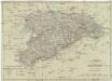
Königreich Sachsen
1 : 632000 Sasko (Německo) Mollo, Tranquillo T. Mollo
Circulus Saxoniae Superioris
1 : 590000 Mollova mapová sbírka Homann, Johann Baptist Homann, Johann Baptista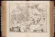
Misnia marchionatvs = Meissen / Jo. Blaeu excu
1 : 440000 titelvariant: Meissen; Annotatie: Origineel is Blad 100 in atlas factice; Annotatie geografische gegevens: Schaalvermelding op kaart: 4 Milliaria Germanica communia; Kaart toont Markgrafschaft Meissen met de steden Naumburg, Leipzig, Meißen en Dresden. Joan Blaeu 1597/98-1673 [Amsterdam : Joan Blaeu]
MISNIA | MARCHIONATVS | Meissen.
Jo. Blaeu Excu.
Misniae et Lvsatiae tabvla
1 Karte : Kupferdruck ; 28 x 20 cm Scultetus; Ortelius s.n.
Misniae et Lvsatiae tabvla
1 Karte : Kupferdruck ; 28 x 20 cm Scultetus; Ortelius s.n.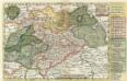
Neue Reise Charte durch Sachsen zu beqvemen Gebrauch
1 : 1500000 Mollova mapová sbírka Schreiber, Johann Georg Schreiber, Johann Georg
Marchionatus Misniae, in qua sunt territorium Misniense, Lipsiense, Voitlandiae, Osterlandiae, Ertzgeburgi, et Dominium Naumburgense, Mersoburgense, Episcopatus Hallensis
1 : 450000 per J. Danckerts Amsterdam : J. Danckerts
Misnia marchionatvs
1 : 450000 Míšeň-oblast (Německo) Blaeu, Joan Jo. Blaeu
[Sasko]
Sasko (Německo) Jacob, Johann Gotthelff
Saxoniae superioris
1 : 500000 Sasko (Německo) Lotter, Tobias Conrad T.C. Lotter
Saxoniae superioris
1 : 500000 Sasko (Německo) Lotter, Tobias Conrad T. C. Lotter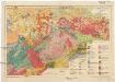
Geologische Übersichtskarte von Sachsen i. M. 1:400 000
1 : 400000 Sasko (Německo) Kossmat, Franz Pietzsch, Kurt Geologischen Landesamt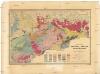
Geognostische General-Charte des Königreichs Sachsen und der angrenzenden Länder-Abtheilungen
1 : 365000 Sasko (Německo) Naumann, Carl Friedrich Williard, J. Königl. Bergakademie
Thuringen u. Sachsen.
1 : 600000 Gutbier, Ludwig von
Ducatus Saxoniae Superioris :
1 : 560000 Mollova mapová sbírka Zollmann, Friedrich Homann, Johann Baptista - dědici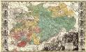
Dvcatvs Electoratus et Principatus Dvcvm Saxoniae pro ut illorum conditio hodierna est Geographice consignati.
1 : 680000 Mollova mapová sbírka Homann, Johann Baptist Homann, Johann Baptista - dědici
![Marchionatus Misniae una cum Voitlandia. [Karte], in: Novus atlas absolutissimus, Bd. 2, S. 69.](https://images-2.georeferencer.com/images/iiif/193529748562/full/,300/0/native.jpg)

