Maps of Slovenia

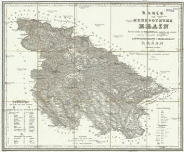
Karte vom Herzogthum Krain
1 : 290000 Kraňsko Loschan, Gottfried Stein, Carl
Reichsratwahlkarte

Königreich Illyrien, gouvernement Laibach
1 : 450000 Ilýrie Renner Apelt, O. C.
Generalkarte von Zentraleuropa

Dioecesan-Carte von Laibach
1 : 260000 Lublaň-oblast (Slovinsko) Mascon, Johann Wolf, Anton Alojzij Johann Mascon
Krain-Küstenland
1 : 850000 Kraňsko Meyer, Joseph Bibliographisches Institut
Der südliche Theil von Untersteyermark oder der Cillier Kreis
1 : 260000 Celje (Slovinsko) Kindermann, Joseph Karl Junker, Christoph Franz Xaver Miller
Karte des Krainisch-Kroatischen Gebirgslandes
1 : 250000 Chorvatsko Ravenstein, Ludwig Ludwig Ravenstein
Übersicht der Krainer Metulum-Hypothesen
1 : 750000 Kroatien Ogulin (Region) Illyrien Augustus
Unter Krain
1 : 500000 Unterkrain
Naseljenost prebivalstva na Kranjskem
1 : 400000 Kraňsko Lončar, Dragotin Kaisvinkler, Bohumil

Celje
1 : 200000 Celje (Slovinsko) Kartografska radionica

Ljubljana
1 : 200000 Lublaň (Slovinsko : oblast) Kartografska radionica
Aus der Übersichtskarte von Mittel-Europa 1:750 000
1 : 750000 Evropa střední K. k. Österreichische Staatsbahnen
Neueste special Karte des Cillier Kreises im Herzogthume Steyermark
1 : 210000 Celje (Slovinsko) Kaiser, Joseph Franz Jos. Fr. Kaiser
Neueste special Karte des Cillier Kreises im Herzogthume Steyermark
1 : 210000 Štýrsko (Rakousko) Kaiser, Jos. Fr. Jos. Fr. Kaiser
Neueste special Karte des Cillier Kreises im Herzogthume Steyermark
1 : 220000 Celje (Slovinsko) Kaiser, Joseph Franz Jos. Fr. Kaiser
Die slovenischen Mundarten
Drau-Gebiet Slowenisch, Mundart
Der Goerzer Kreis und der Triester Kreis
1 : 260000 Gorizia (Itálie) Kindermann, Joseph Karl Junker, Christoph Franz Xaver Miller
Ducatus Carnioliae Tabula Chorographica Iusu Sumptuque inclytorum Provinciae Statuum.
1 : 100000 Mollova mapová sbírka Florjančič de Grienfeld, Janez Dizma
Ducatus Carnioliae Tabula Chorographica Iusu Sumptuque inclytorum Provinciae Statuum.
1 : 100000 Mollova mapová sbírka Florjančič de Grienfeld, Janez Dizma
Ducatus Carnioliae Tabula Chorographica Iusu Sumptuque inclytorum Provinciae Statuum.
1 : 100000 Mollova mapová sbírka Florjančič de Grienfeld, Janez Dizma
Cilli und Ratschach.
from Spezialkarte der osterreichisch-ungarischen Monarchie.
Bischoflack und Idria.
from Spezialkarte der osterreichisch-ungarischen Monarchie.
Yugoslavia 1:100,000, Novo Mesto
Yugoslavia 1:100,000 , Series GSGS 4396. Great Britain. War Office. [London] : War Office
Laibach.
from Spezialkarte der osterreichisch-ungarischen Monarchie.
Yugoslavia 1:100,000, Ljubljana
Yugoslavia 1:100,000 , Series GSGS 4396. Great Britain. War Office. [London] : War Office