Maps of Villach-Land

Aus der Übersichtskarte von Mittel-Europa 1:750 000
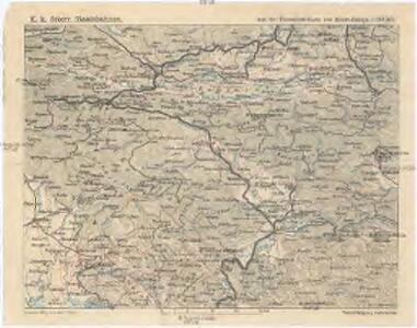
1 : 750000 Evropa střední K. k. Österreichische Staatsbahnen
Carinthiae Dvcatvs, Et Goritiae Palatinatvs
1 : 460000 Mollova mapová sbírka Lazius, Wolfgang
G. Freytags Karte der Isonzo-Front
1 : 350000 Gorizia (Itálie : provincie) Kartogr. Anstalt G. Freytag & Berndt

Generalkarte von Zentraleuropa

Dioecesan-Carte von Laibach
1 : 260000 Lublaň-oblast (Slovinsko) Mascon, Johann Wolf, Anton Alojzij Johann Mascon
Ljubljana
1 : 200000 Lublaň (Slovinsko : oblast) Kartografska radionica

Der Goerzer Kreis und der Triester Kreis
1 : 260000 Gorizia (Itálie) Kindermann, Joseph Karl Junker, Christoph Franz Xaver Miller
Comitatus Goritiae et Gradiscae cum limitibus Venetis et vicinia
1 : 220000 Benátky (Itálie) Coronini, Rudolf Quischae, D.
Comitatus Goritiae et Gradiscae
1 : 216000 Mollova mapová sbírka Coronini, Rudolf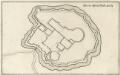
Gründt Riß der Statt Görtz
Mollova mapová sbírka Merian, Matthaeus Merian, Caspar
Naseljenost prebivalstva na Kranjskem
1 : 400000 Kraňsko Lončar, Dragotin Kaisvinkler, Bohumil
Comitatus Goritiae Et Finitima
1 : 115000 Mollova mapová sbírka Coronini, Rudolf Winkler, Johann Christoph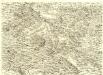
Ducatus Carnioliae Tabula Chorographica Iusu Sumptuque inclytorum Provinciae Statuum.
1 : 100000 Mollova mapová sbírka Florjančič de Grienfeld, Janez Dizma
Bischoflack und Idria.
from Spezialkarte der osterreichisch-ungarischen Monarchie.
Tolmein.
from Spezialkarte der osterreichisch-ungarischen Monarchie.
Laibach.
from Spezialkarte der osterreichisch-ungarischen Monarchie.
Yugoslavia 1:100,000, Ljubljana
Yugoslavia 1:100,000 , Series GSGS 4396. Great Britain. War Office. [London] : War Office
Klagenfurt und Villach.
from Spezialkarte der osterreichisch-ungarischen Monarchie.
Bleiberg und Tarvis.
from Spezialkarte der osterreichisch-ungarischen Monarchie.
Eisenkappel und Kanker.
from Spezialkarte der osterreichisch-ungarischen Monarchie.
Yugoslavia 1:100,000, Bled
Yugoslavia 1:100,000 , Series GSGS 4396. Great Britain. War Office. [London] : War Office
Flitsch.
from Spezialkarte der osterreichisch-ungarischen Monarchie.
Volkermarkt.
from Spezialkarte der osterreichisch-ungarischen Monarchie.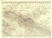
Ducatus Carnioliae Tabula Chorographica Iusu Sumptuque inclytorum Provinciae Statuum.
1 : 100000 Mollova mapová sbírka Florjančič de Grienfeld, Janez Dizma
Radmannsdorf.
from Spezialkarte der osterreichisch-ungarischen Monarchie.
Nördliches Isonzogebiet
Isonzo-Gebiet Isonzoschlachten
Die Flurformen des südlichen Jauntals, der nördlichen oberkrainischen Ebene, sowie der Steiner Alpen und Ost Karawanken, n.d. Franziszeischen Kataster 1825-1828
1 : 115200 Oberkrain Landschaftsgliederung, Flurform