Maps of Zagrebacka
Karte des Krainisch-Kroatischen Gebirgslandes
1 : 250000 Chorvatsko Ravenstein, Ludwig Ludwig Ravenstein
Mappa comitatus Zagrabiensis
1 : 240000 Záhřeb-oblast (Chorvatsko) Szemán, Joseph Kaiser, J. F.
Krain-Küstenland
1 : 850000 Kraňsko Meyer, Joseph Bibliographisches Institut
Karte vom Herzogthum Krain
1 : 290000 Kraňsko Loschan, Gottfried Stein, Carl
Unter Krain
1 : 500000 Unterkrain

Übersicht der Krainer Metulum-Hypothesen
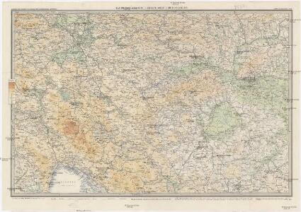
1 : 750000 Kroatien Ogulin (Region) Illyrien Augustus
Celje
1 : 200000 Celje (Slovinsko) Kartografska radionica
Naseljenost prebivalstva na Kranjskem
1 : 400000 Kraňsko Lončar, Dragotin Kaisvinkler, Bohumil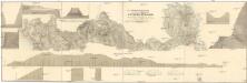
Situations Plan der königlich ungarisch priv. Louisen Strasse
1 : 73000 Metlika (Slovinsko) Schönvisner
Stÿriae Ducatus Fertilisimi Nova Geographica Descriptio
1 : 200000 Mollova mapová sbírka Vischer, Georg Matthaeus Trost, Andreas
Ducatus Carnioliae Tabula Chorographica Iusu Sumptuque inclytorum Provinciae Statuum.
1 : 100000 Mollova mapová sbírka Florjančič de Grienfeld, Janez Dizma
Ducatus Carnioliae Tabula Chorographica Iusu Sumptuque inclytorum Provinciae Statuum.
1 : 100000 Mollova mapová sbírka Florjančič de Grienfeld, Janez Dizma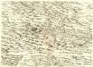
Ducatus Carnioliae Tabula Chorographica Iusu Sumptuque inclytorum Provinciae Statuum.
1 : 100000 Mollova mapová sbírka Florjančič de Grienfeld, Janez Dizma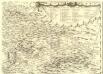
Ducatus Carnioliae Tabula Chorographica Iusu Sumptuque inclytorum Provinciae Statuum.
1 : 100000 Mollova mapová sbírka Florjančič de Grienfeld, Janez Dizma
Altenmarkt und Ogulin.
from Spezialkarte der osterreichisch-ungarischen Monarchie.
Fiume und Delnice.
from Spezialkarte der osterreichisch-ungarischen Monarchie.
Yugoslavia 1:100,000, Samobor
Yugoslavia 1:100,000 , Series GSGS 4396. Great Britain. War Office. [London] : War Office
Yugoslavia 1:100,000, Novo Mesto
Yugoslavia 1:100,000 , Series GSGS 4396. Great Britain. War Office. [London] : War Office
Weixelburg und Zirknitz.
from Spezialkarte der osterreichisch-ungarischen Monarchie.
Gurkfeld.Rann und Samobor.
from Spezialkarte der osterreichisch-ungarischen Monarchie.
Rudolfswerth.
from Spezialkarte der osterreichisch-ungarischen Monarchie.
Yugoslavia 1:100,000, Cerknica
Yugoslavia 1:100,000 , Series GSGS 4396. Great Britain. War Office. [London] : War Office
Gottschee und Tschernembl.
from Spezialkarte der osterreichisch-ungarischen Monarchie.
Laas und Cabar.
from Spezialkarte der osterreichisch-ungarischen Monarchie.
Italy 1:100,000 / Sardinia 1:100,000, Fumia
Italy 1:100,000 / Sardinia 1:100,000 , Series GSGS 4164. Great Britain. War Office. General Staff. Geographical Section. [London] : War Office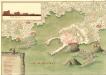
Desegno de la Forteza di Porto Re in Liburnia
Mollova mapová sbírka Geyer
Italy 1:100,000 / Sardinia 1:100,000, Postumia
Italy 1:100,000 / Sardinia 1:100,000 , Series GSGS 4164. Great Britain. War Office. General Staff. Geographical Section. [London] : War Office
Velika Corica und Lekenik.
from Spezialkarte der osterreichisch-ungarischen Monarchie.