Maps of Syria

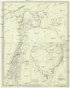
Ancient Syria
1 : 2200000 Blízký východ Hughes, William Chapman & Hall
Syria to Sinai.
1 : 2200000 Society for the Diffusion of Useful Knowledge (Great Britain)
Afbeelding van 't Koningryk Israëls, benevens de door 't zelve overheerde landen; gedurende de regering der koningen Saul, David, en Salomo
1 : 2300000 door W.A. Bachiene J. van Jagen mapp. sculpsit, et figur. apposit. sculpturam curavit ; J. Folkema f. Uitgegeven te Gorinchem : by Nicolaas Goetzee
Places Recorded in the Five Books of Moses.
1 : 4700000 Finley, Anthony
Syria.
1 : 6500000 Fenner, Rest.
Places Recorded in the Five Books of Moses. (1826)
1 : 4600000 Tanner, Henry S.
Abrahami Patriarchae Peregrinatio, Et Vita. [Karte], in: Theatrum orbis terrarum, S. 444.
1 Karte aus Atlas Ortelius, Abraham Vrients, Jan Baptista
Syria.
1 : 3801600 Tallis, J. & F.
General - Karte von Europa mit Klein - Asien und dem nördlichen Afrika

Situs Terrae Promissionis. S.S. Bibliorum intelligentiam exacte aperiens [Karte], in: Gerardi Mercatoris et I. Hondii Newer Atlas, oder, Grosses Weltbuch, Bd. 2, S. 347.
1 Karte aus Atlas Mercator, Gerhard und Hondius, Jodocus Jansson, Jan
Übersichtskarte Konya-Kairo
1 : 1000000 Gen St d H Abt f Kr Kart u Verm Wes
Syriae.
1 : 2400000 Vivien de St Martin, L.
Carte de la Syrie
Nouvel atlas physique politique et historique de l'Empire ottoman et des états limitrophes en Europe, en Asie et en Afrique, en quarante feuilles Hellert, J.J. Bellizard, Dufour et Cie
Die sogenannten Missionen der Central-TürkeiDas Gebiet der Nestorianer

Syrien u. Aegypten
[Allgemeiner Atlas über alle Theile der Erde in 29 Blättern] Ziegler, Jakob Melchior Top. Anstalt v. J. Wurster u. Comp.
Feuille 48 (F VII), uit: Carte géologique internationale de l'Europe : la carte, votée au congrès géologique international de Bologne en 1881, est exécutée conformément aux décisions d'une commission internationale, avec le concours des gouvernements, sous le dir. de M.M. Beyrich et Hauchecorne
Annotatie: Blad 48 gamme des couleurs; blad 49: bladwijzer en titelblad Heinrich Ernst Beyrich 1815-1896; Wi. Hauchecorne Berlin : Reimer / (Berlin: Institut lithographique)
[Syrien und Aegypten]
Hypsometrischer Atlas Ziegler, Jakob Melchior Topogr. Anstalt v. J. Wurster u. Comp.
Syrien und die angraenzenden Laender zur Zeit der Kreuzzuge.
1 : 3000000 Spruner von Merz, Karl
Palaestinae Sive Totius Terrae Promissionis Nova Descriptio [Karte], in: Theatrum orbis terrarum, S. 435.
1 Karte aus Atlas Ortelius, Abraham Vrients, Jan Baptista

Situs Terrae Promissionis. S.S. Bibliorum intelligentiam exacte aperiens [Karte], in: Novus atlas absolutissimus, Bd. 6, S. 108.
1 Karte aus Atlas Janssonius Offizin
Terra Sancta quae in Sacris Terra Promissionis olim Palestina [Karte], in: Novus Atlas, das ist, Weltbeschreibung, Bd. 2, S. 300.
1 Karte aus Atlas Blaeu, Joan Blaeu, Willem Janszoon
Ancient Syria to Sinai.
1 : 2200000 Society for the Diffusion of Useful Knowledge (Great Britain)
Syrie et de la Palestine, 624 ans apres J.C.
1 : 3300000 Houze, Antoine Philippe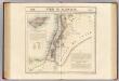
Syrie et Palestine. Asie 63.
1 : 1641836 Vandermaelen, Philippe, 1795-1869
Die Reiche der Kreuzfahrer um 1142
Kreuzfahrerstaaten
[Recto], uit: Terra Sancta qua in Sacris Terra Promissionis olim Palestina / [Willem Jansz. Blaeu]
1 : 1000000 Annotatie: Uit: Tweede deel van 't Toonneel des Aerdriicx, ofte Nieuwe atlas. - Amsterdami : apud Guiljelmum et Iohannem Blaeu, 1635 [of latere editie]; Annotatie geografische gegevens: Noordwest boven Blaeu, Willem Jansz. Amstelodami : ex officina Guiljelmi Blaeu
Terre Sainte en 1839.
1 : 3300000 Houze, Antoine Philippe
Syria
1 : 2200000 Hughes, William, 1817-1876 George Cox