Maps of Levant Coast

Syrie et de la Palestine, 624 ans apres J.C.
1 : 3300000 Houze, Antoine Philippe
Syrien und die angraenzenden Laender zur Zeit der Kreuzzuge.
1 : 3000000 Spruner von Merz, Karl
Terre Sainte, pendant la premiere croisade de 1096 a 1144.
1 : 3300000 Houze, Antoine Philippe
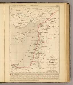
Terre Sainte en 1839.
1 : 3300000 Houze, Antoine Philippe
Übersichtskarte Konya-Kairo
1 : 1000000 Gen St d H Abt f Kr Kart u Verm Wes
La nvova et esatta descrittione della Soria, e della Terra Santa
Kypr Forlani, Paolo da Paulo Furlani Veronese
La Palestine...

Syria.
1 : 6500000 Fenner, Rest.
Die Reiche der Kreuzfahrer um 1142
Levante, Kreuzfahrerstaaten
Die Reiche der Kreuzfahrer um 1142
Kreuzfahrerstaaten
Terre Sainte depuis la deuxieme croisade.
1 : 3300000 Houze, Antoine Philippe
Syria.
1 : 3801600 Tallis, J. & F.
Syrie et Palestine. Asie 63.
1 : 1641836 Vandermaelen, Philippe, 1795-1869
Carte De La Mer Mediterranee. X.
Roux, Joseph
Ancient Syria to Sinai.
1 : 2200000 Society for the Diffusion of Useful Knowledge (Great Britain)
Syriae.
1 : 2400000 Vivien de St Martin, L.
Iudaea seu Terra Sancta quae Hebraeorum sive Israelitarum in suas duodecim Tribus divisa; secretis ab invicem Regnis Iuda, et Israel [...] [Karte], in: Atlas nouveau, contenant toutes les parties du monde [...], Bd. 2, S. 212.
1 Karte aus Atlas Sanson, Nicolas Jaillot, Alexis Hubert und Mortier, Pieter
De beyde koningryken Juda en Israël, die na Salomo's dood zig van elkanderen afgescheurt hebben; benevens de overheerde landen aan elk dier beiden behorende
1 : 1400000 afgebeeldt door W.A. Bachiene J. van Jagen mapp. sculpsit, et figur. apposit. sculpturam curavit ; S. Fokke fec. Uitgegeven te Gorinchem : by Nicolaas Goetzee
[Recto], uit: Situs terrae promissionis. S.S. Bibliorum intelligentiam exacte aperiens / per Chr. Adrichom ; sculpserunt Everardus Sim. Hamers-veldt et Salomon Rogeri
1 : 830000 Annotatie: Oorspr. verschenen in: L'Appendice de l'atlas de Gerard Mercator et Iudocus Hondius ... - A Amsterdam : chez Henry Hondius, 1633; Annotatie geografische gegevens: Zuidoost boven Adrichom, Christiaan van; Hamersveldt, Everard Symonsz. van; Rogiers, Salomon Amstelodami : sumptibus Henrici Hondii
Ancient and Modern Syria.
1 : 1770000 Playfair, Principal
Terra Sancta XVI. Nova Tab. [Karte], in: Geographia universalis vetus et nova complectens Claudii Ptolemaei Alexandrini enarrationis libros VIII, S. 344.
1 Karte aus Atlas Münster, Sebastian [und Ptolemaeus, Claudius]
Syriæ, sive Soriæ : nova et accurata descriptio
1 : 1300000 Annotatie: Kaart vervaardigd in ca. 1658; Kaart uitg. tussen ca. 1658-ca. 1680; Origineel is Blad 182 in atlas factice; Annotatie geografische gegevens: Schaalstokken op kaart: 15 Milliaria Germanica Communia (=8,3 cm), en: 20 Milliaria Gallica Communia (=8,3 cm) Johannes Janssonius 1588-1664 Amstelodami : sumptibus Ioannis Ianssonii
Terra Sancta XXIII. Nova Tabula. [Karte], in: Claud. Ptolemaeus. Geographia lat. cum mappis [...], S. 431.
1 Karte aus Atlas Münster, Sebastian [und Ptolemaeus, Claudius]
Syriae. Sive Soriae. Nova et Accurata descriptio. [Karte], in: Novus atlas absolutissimus, Bd. 6, S. 105.
1 Karte aus Atlas Janssonius Offizin
Carte de la Terre Promise
1 : 1600000 Izrael
Syria
1 : 2200000 Hughes, William, 1817-1876 George Cox
Palaestina
Grosser Hand-Atlas über alle Theile der Erde in 170 Karten Meyer, J. Verlag des Bibliographischen Instituts
Typus Chorographicus, Celebrium Locorum In Regno Iudae Et Israhel. [Karte], in: Theatrum orbis terrarum, S. 436.
1 Karte aus Atlas Ortelius, Abraham