Maps of Levant Coast

Terre Sainte en 1839.
1 : 3300000 Houze, Antoine Philippe
Terre Sainte, pendant la premiere croisade de 1096 a 1144.
1 : 3300000 Houze, Antoine Philippe
Syrie et de la Palestine, 624 ans apres J.C.
1 : 3300000 Houze, Antoine Philippe
Syrien und die angraenzenden Laender zur Zeit der Kreuzzuge.
1 : 3000000 Spruner von Merz, Karl
La nvova et esatta descrittione della Soria, e della Terra Santa
Kypr Forlani, Paolo da Paulo Furlani Veronese
Terre Sainte depuis la deuxieme croisade.
1 : 3300000 Houze, Antoine Philippe
La Palestine...

Die Reiche der Kreuzfahrer um 1142
Levante, Kreuzfahrerstaaten
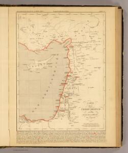
Syria.
1 : 6500000 Fenner, Rest.
Die Reiche der Kreuzfahrer um 1142
Kreuzfahrerstaaten
Syrie et Palestine. Asie 63.
1 : 1641836 Vandermaelen, Philippe, 1795-1869
Carte De La Mer Mediterranee. X.
Roux, Joseph
Ancient Syria to Sinai.
1 : 2200000 Society for the Diffusion of Useful Knowledge (Great Britain)
De beyde koningryken Juda en Israël, die na Salomo's dood zig van elkanderen afgescheurt hebben; benevens de overheerde landen aan elk dier beiden behorende
1 : 1400000 afgebeeldt door W.A. Bachiene J. van Jagen mapp. sculpsit, et figur. apposit. sculpturam curavit ; S. Fokke fec. Uitgegeven te Gorinchem : by Nicolaas Goetzee
Ancient and Modern Syria.
1 : 1770000 Playfair, Principal
Terra Sancta XVI. Nova Tab. [Karte], in: Geographia universalis vetus et nova complectens Claudii Ptolemaei Alexandrini enarrationis libros VIII, S. 344.
1 Karte aus Atlas Münster, Sebastian [und Ptolemaeus, Claudius]
Palaestina.
1 : 1140000 Flemming, Carl
Syriæ, sive Soriæ : nova et accurata descriptio
1 : 1300000 Annotatie: Kaart vervaardigd in ca. 1658; Kaart uitg. tussen ca. 1658-ca. 1680; Origineel is Blad 182 in atlas factice; Annotatie geografische gegevens: Schaalstokken op kaart: 15 Milliaria Germanica Communia (=8,3 cm), en: 20 Milliaria Gallica Communia (=8,3 cm) Johannes Janssonius 1588-1664 Amstelodami : sumptibus Ioannis Ianssonii
Terra Sancta XXIII. Nova Tabula. [Karte], in: Claud. Ptolemaeus. Geographia lat. cum mappis [...], S. 431.
1 Karte aus Atlas Münster, Sebastian [und Ptolemaeus, Claudius]
Carte de la Terre Promise
1 : 1600000 Izrael
Palaestina
Grosser Hand-Atlas über alle Theile der Erde in 170 Karten Meyer, J. Verlag des Bibliographischen Instituts
Syriae. Sive Soriae. Nova et Accurata descriptio. [Karte], in: Novus atlas absolutissimus, Bd. 6, S. 105.
1 Karte aus Atlas Janssonius Offizin
La Terre Sainte partagee en 12 tribus.
1 : 2800000 Houze, Antoine Philippe
Syria
1 : 2200000 Hughes, William, 1817-1876 George Cox
Palästina
Hand-Atlas über alle Theile der Erde und über das Weltgebäude Stieler, Adolf Justus Perthes
Terre Sainte divisee en royaumes d'Israel et de Juda de 975 a 588.
1 : 2700000 Houze, Antoine Philippe

Typus Chorographicus, Celebrium Locorum In Regno Iudae Et Israhel. [Karte], in: Theatrum orbis terrarum, S. 436.
1 Karte aus Atlas Ortelius, Abraham
Judaea seu duodecim tribus Israelis
1 : 10670000 Izrael Bonne, Rigobert André