Maps of Ventspils novads

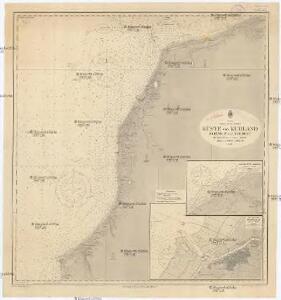
Ostsee
1 : 150000 Baltské moře Reichs-Marine-Amt
Ostsee
1 : 150000 Baltské moře Reichs-Marine-Amt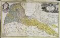
Dvcatvs Cvrlandiæ jux.ta Barnikelii architecti curici primarii geometricam delineationem geographica tabula expressus
1 Karte : Kupferdruck ; 47 x 34 cm Barnickel Homännische Erben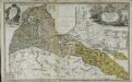
Dvcatvs Cvrlandiæ jux.ta Barnikelii architecti curici primarii geometricam delineationem geographica tabula expressus
1 Karte : Kupferdruck ; 48 x 34 cm Barnickel Homännische Erben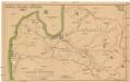
Latwijas dselsszełu schematiska karte
1 : 665000 Lotyšsko Jaunsems, B.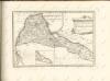
Latvija
1 : 300000 Lotyšsko Olava fonda izdevums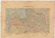
Latwijas Karte
1 : 800000 Lotyšsko Armijas Wirspawehlneeka Schtaba Topografijas
Lettland
1 : 420000 Lotyšsko Endzelin, J. Karthographischen Institut A. Ošinš & P. Mantnieks
Windau, I. Ösel, Dünamünde
1 : 750000 baltské země K. u. k. Militärgeographisches Institut
Übersichtskarte von Mittel - Europa

Übersichtskarte von Mittel - Europa

Perillustribus generosissimis magnificis & excelentissimis dominis dominis dvcatvvm Cvrlandiae & Semgalliae quatuor consiliaris supremis tabulam hanc dvcatvvm Cvrlandiae & Semgalliae
1 : 142000 Kuronsko Barnikel, Johannes Christoph Homanniani Heredes
Ostsee
1 : 150000 Baltské moře Reichs-Marine-Amt
Topographische Charte von Liw-Laett u. Eestland zu Anfang des 13ten Jahrhunderts
Estonsko

DVCATVVM LIVONIAE et CVRLANDIAE cum vicinis Insulis Nova Exhibitio Geographica
1 : 917000 Estonsko Homann, Johann Baptist Ioh. Baptista Homanno
Dvcatvvm Livoniae et Cvrlandiae cum vicinis insulis nova exhibitio geographica
1 : 895000 Estonsko Homann, Johann Baptist Ioh. Baptista Homanno
Esthland, Livland, Kurland 1480 bis 1682
1 : 6000000 Baltikum
Livoniae et Curlandiae ducatus cum insulis adjacentib. mappa geographica
1 : 1900000 Estonsko Seutter, Matthäus Drentwett, Abraham per Matthaeum Seutter
Esthland, Livland, Kurland in den Jahren 1346 bis 1480
1 : 6000000 Baltikum

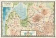
Verwaltungsgebiet Ober Ost und geschlossene Sprachgebiete
Baltikum Oberost Weltkrieg <1914-1918>
Livonia
1 Karte : Kupferdruck ; 35 x 46 cm Mercator; Hondius sumptibus Henrici Hondij
Esthland, Livland, Kurland zur Zeit des Schwertordens 1201 - 1237
1 : 5000000 Baltikum Schwertbrüderorden
Verwaltungsgebiet Ober Ost. Einteilung der Kreise und Eisenbahnlinien
Baltikum Oberost Weltkrieg <1914-1918> Eisenbahnnetz
Esthland, Livland, Kurland vom Frieden von Stenby 1238 bis zur Abtretung des Dänischen Theils von Esthland an den Deutschen Orden 1346
1 : 6000000 Baltikum
Die Russischen Ost-See-Provinzen Livland Ehstland und Kurland
Grosser Hand-Atlas über alle Theile der Erde in 170 Karten Meyer, J. Verlag des Bibliographischen Instituts
Kalnuotumo ir nuotakumo Lietuvos
1 : 630000 Lotyšsko Matulionis, P. S. Schropp'sche Lehrmittel-Handlung