Maps of Courland
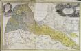
Dvcatvs Cvrlandiæ jux.ta Barnikelii architecti curici primarii geometricam delineationem geographica tabula expressus
1 Karte : Kupferdruck ; 47 x 34 cm Barnickel Homännische Erben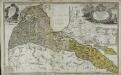
Dvcatvs Cvrlandiæ jux.ta Barnikelii architecti curici primarii geometricam delineationem geographica tabula expressus
1 Karte : Kupferdruck ; 48 x 34 cm Barnickel Homännische Erben
Ostsee
1 : 150000 Baltské moře Reichs-Marine-Amt
Ostsee
1 : 150000 Baltské moře Reichs-Marine-Amt
2. Paaschken, uit: Topographische Uebersichtskarte des Deutschen Reiches / herausgegeben v. d. Kartogr. Abt. d. Königl. Preuß. Landesaufnahme
1 : 200000 titelvariant: Topogr. Übersichtskarte des Deutschen Reiches; Annotatie: Titel boven bladen ook: Topogr. Übersichtskarte des Deutschen Reiches; Annotatie geografische gegevens: Op elk blad twee maatstokken: 10 Kilometer = 5,5 cm; 1 geogr. Meile = 3,6 cm; Legenda onder op elk blad Königlich Preußische Landesaufnahme. Kartographische Abtheilung [S.l : Königlich Preußische Landesaufnahme, Kartographische Abtheilung]
2. (1. Crottingen) Schlattern. (Germany)
1 : 100000 Reichsamt fur Landesaufnahme
Composite: 2. (1. Crottingen) Schlattern. (Germany)
1 : 100000 Reichsamt fur Landesaufnahme
1. Crottingen (2. Schlattern). (Germany)
1 : 100000 Reichsamt fur Landesaufnahme
Karte des westlichen Russlands K18

Karte des westlichen Russlands L18

Karte des westlichen Russlands K16

Messtischblatt 294 : Laugallen, 1940 Laugallen
1 : 250000 Laugallen. - Aufnahme 1910, redakt. Änd. 1940, hrsg. 1911.. - 1:25000. - [Berlin]: Reichsamt für Landesaufnahme, 1940. - 1 Kt.
Messtischblatt 292 : Memel, 1942 Memel
1 : 250000 Memel. - Aufnahme 1910, berichtigt 1940, hrsg. 1912.. - 1:25000. - [Berlin]: Reichsamt für Landesaufnahme, 1942. - 1 Kt.
Messtischblatt 293 : Plicken, 1940 Plicken
1 : 250000 Plicken. - Aufnahme 1910, hrsg. 1912, letzte Nachtr. 1940. - 1:25000. - [Berlin]: Reichsamt für Landesaufnahme, 1941. - 1 Kt.
Messtischblatt 194 : Jakubowo, 1940 Jakubowo
1 : 250000 Jakubowo. - Hrsg. 1911, vorläuf. Ausg. 1940. - 1:25000. - [Berlin]: Reichsamt für Landesaufnahme, 1940. - 1 Kt.
Messtischblatt 0192 : Nimmersatt, 1939 Nimmersatt
1 : 250000 Nimmersatt. - Hrsg. 1912., redakt. Änd. 1939.. - 1:25000. - [Berlin]: Reichsamt für Landesaufnahme, 1939. - 1 Kt.
Messtischblatt 0193 : Dtsch. Crottingen, 1940 Dtsch. Crottingen
1 : 250000 Dtsch. Crottingen. - Hrsg. 1912. - 1:25000. - [Berlin]: Reichsamt für Landesaufnahme, 1940. - 1 Kt.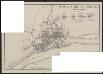
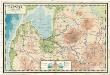
Plan von Memel und Umgegend
Litauen Memel Klaipėda H. Wagner & E. Debes (Leipzig)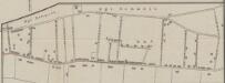
[Nebenkarte Kgl. Schmelz]
Litauen Memelland Memel Stadtviertel Stadtplan
[Umgebungsplan Memel]
1 : 300000 Litauen Ostpreußen Memel Umland
Messtischblatt 0394 : Dawillen, 1939 Dawillen
1 : 250000 Dawillen. - Hrsg. 1911, red. Änd. 1939. - 1:25000. - [Berlin]: Reichsamt für Landesaufnahme, 1939. - 1 Kt.
Messtischblatt 393 : Götzhöfen, 1940 Götzhöfen
1 : 250000 Götzhöfen. - Aufn. 1910, letzt. Nachtr. 1940, hrsg. 1912.. - 1:25000. - [Berlin]: Reichsamt für Landesaufnahme, 1940. - 1 Kt.
Messtischblatt 392 : Schmelz, 1936 Schmelz
1 : 250000 Schmelz. - Redakt. Änd. 1939, hrsg. 1912.. - 1:25000. - [Berlin]: Reichsamt für Landesaufnahme, 1939. - 1 Kt.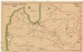
Latwijas dselsszełu schematiska karte
1 : 665000 Lotyšsko Jaunsems, B.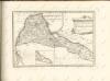
Latvija
1 : 300000 Lotyšsko Olava fonda izdevums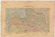
Latwijas Karte
1 : 800000 Lotyšsko Armijas Wirspawehlneeka Schtaba Topografijas
Lettland
1 : 420000 Lotyšsko Endzelin, J. Karthographischen Institut A. Ošinš & P. Mantnieks
Übersichtskarte von Mittel - Europa


