Maps of Latvia
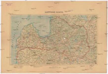
Latwijas Karte
1 : 800000 Lotyšsko Armijas Wirspawehlneeka Schtaba Topografijas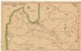
Latwijas dselsszełu schematiska karte
1 : 665000 Lotyšsko Jaunsems, B.
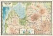
Latvija
1 : 300000 Lotyšsko Olava fonda izdevums
Esthland, Livland, Kurland in den Jahren 1346 bis 1480
1 : 6000000 Baltikum
Lettland
1 : 420000 Lotyšsko Endzelin, J. Karthographischen Institut A. Ošinš & P. Mantnieks
Topographische Charte von Liw-Laett u. Eestland zu Anfang des 13ten Jahrhunderts
Estonsko
Strategische Übersichts-Karte des polnisch-litaurischen Armee-Bewegungraumes
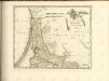
Ducatuum Livoniae et Curlandiae novissima tabula in quibus sunt Estonia Litlandia et aliae minores provinciae
1 : 970000 1 Karte : Kupferdruck ; 47 x 56 cm Danckerts, Justus [Danckerts]
Skizze des Vormarsches der 8. Armee in Livland und Estland
1 : 1050000 Baltikum Weltkrieg <1914-1918> Verl. Gerhard Stalling, Oldenburg
Dvcatvvm Livoniæ et Cvrlandiæ cum vicinis insulis nova exhibitio geographica
1 Karte : Kupferdruck ; 47 x 56 cm Homann Johann Baptist Homann
Dvcatvvm Livoniæ et Cvrlandiæ cum vicinis insulis nova exhibitio geographica / editore Ioh. Baptis
1 : 910000 1 Karte : Kupferdruck ; 47 x 57 cm Homann, Johann Baptist [Johann Baptist Homann]
Übersichtskarte von Liv-, Est- und Kurland
1 : 1000000 Baltikum Weltkrieg <1914-1918> Verl. Gerhard Stalling, Oldenburg
Das Deutschtum II. 1.
Baltikum Ethnische Gruppe, Deutsche
Tabula ducatuum Livoniae et Curlandiae
1 : 1000000 recentior incisa editaque per Gerardum Valck [Amsterdam] : per Gerardum Valck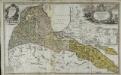
Per illustribus, generosissimis magnificis & excellentissimis dominis, dominis dvcatvvm Cvrlandiæ & Semgalliæ quatuor consiliariis supremis tabulam hanc dvcatvvm Cvrlandiæ & Semgalliæ geographicam
1 Karte : Kupferdruck ; 48 x 44 cm Barnickel Homännische Erben
Per illustribus, generosissimis magnificis & excellentissimis dominis, dominis dvcatvvm Cvrlandiæ & Semgalliæ quatuor consiliariis supremis tabulam hanc dvcatvvm Cvrlandiæ & Semgalliæ geographicam
1 Karte : Kupferdruck ; 48 x 44 cm Barnickel Homännische Erben
Perillustribus generosissimis magnificis & excelentissimis dominis dominis dvcatvvm Cvrlandiae & Semgalliae quatuor consiliaris supremis tabulam hanc dvcatvvm Cvrlandiae & Semgalliae
1 : 142000 Kuronsko Barnikel, Johannes Christoph Homanniani Heredes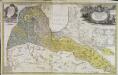
Dvcatvs Cvrlandiæ jux.ta Barnikelii architecti curici primarii geometricam delineationem geographica tabula expressus
1 Karte : Kupferdruck ; 47 x 34 cm Barnickel Homännische Erben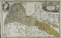
Dvcatvs Cvrlandiæ jux.ta Barnikelii architecti curici primarii geometricam delineationem geographica tabula expressus
1 Karte : Kupferdruck ; 48 x 34 cm Barnickel Homännische Erben
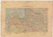
Dwinsk (Dünaburg), Friedrichstadt
1 : 750000 Dokšycy (Bělorusko) K. u. k. Militärgeographisches Institut
Paasche's Frontenkarte, Nr.10. Der Krieg gegen Russland

Riga, Libau, Memel, Kowno
1 : 750000 Kaunas (Litva) K. u. k. Militärgeographisches Institut
Übersichtskarte von Mittel - Europa

Schawli 7, uit: Special-Karte von Mittel-Europa / nach amtlichen Quellen bearbeitet von W. Liebenow
1 : 300000 titelvariant: W. Liebenow's Mittel-Europa; Annotatie: Titel boven de bladen: W. Liebenow's Mittel-Europa Johannes Wilhelm Liebenow 1822-1897 Frankfurt a. M. : Ludwig Ravenstein
Ostsee
1 : 150000 Baltské moře Reichs-Marine-Amt
Ostsee
1 : 150000 Baltské moře Reichs-Marine-Amt