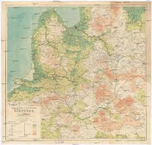
Maps of Lithuania

Kalnuotumo ir nuotakumo Lietuvos
1 : 630000 Lotyšsko Matulionis, P. S. Schropp'sche Lehrmittel-Handlung
Übersichtskarte von Ostpreußen, Kurland und den angrenzenden Gebieten
1 : 750000 Kuronsko k. u. k. Hof- und Universitätsbuchhandlung R. Lechner (W. Müller)
Mapa nowej unji Polski z Litwą
1 : 2000000 Bělorusko Romer, Eugeniusz Instytut kartograficzny Atlas
[Litauen, Lettland]
Litauen, Lettland, ethnische Gruppe
Litauen, Kurland und Livland
1 : 725000 Kuronsko Carl Flemming
Verwaltungsgebiet Ober Ost. Einteilung der Kreise und Eisenbahnlinien
Baltikum Oberost Weltkrieg <1914-1918> Eisenbahnnetz
Verwaltungsgebiet Ober Ost und geschlossene Sprachgebiete
Baltikum Oberost Weltkrieg <1914-1918>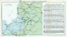
Nr. 7. Kämpfe in Kurland und Nordpolen zum Schutze Ostpreußens
Baltikum Weltkrieg <1914-1918>, Ostfront
Paasche's Frontenkarte, Nr.6. Der Krieg gegen Russland

Carte des operations du corps d'armée commandé par le général polonais, Henri Dembinski en 1831
Litauen Weißrussland Polen / Aufstand <1830-1831> Dembiński, Henryk Dembiński, Henryk
Ethnographische Karte von Litauen
1 : 2000000 Litauen Ethnische Gruppe Kettler, Julius Iwan (red.)
Mapa narodowościowa polskich kresów północno-wschodnich i Litwy
1 : 1000000 Litva Machlejd, Jerzy Zaborski, Bogdan Gebethner & Wolff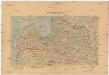
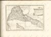
Latwijas Karte
1 : 800000 Lotyšsko Armijas Wirspawehlneeka Schtaba Topografijas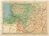
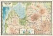
Lietuvos žemelapis
1 : 200000 Litva Spaudos fondas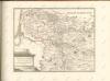

Strategische Übersichts-Karte des polnisch-litaurischen Armee-Bewegungraumes

Übersichtskarte von Mittel - Europa
Latwijas dselsszełu schematiska karte
1 : 665000 Lotyšsko Jaunsems, B.
Paasche's Frontenkarte, Nr.10. Der Krieg gegen Russland
Latvija
1 : 300000 Lotyšsko Olava fonda izdevums
Lettland
1 : 420000 Lotyšsko Endzelin, J. Karthographischen Institut A. Ošinš & P. Mantnieks
Übersichtskarte von Mittel - Europa

Riga, Libau, Memel, Kowno
1 : 750000 Kaunas (Litva) K. u. k. Militärgeographisches Institut
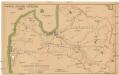
Wiłkomierz, Dwinsk (Dünaburg), Wilna, Wilejka, Słonim, Mińsk
1 : 300000 Minsk (Bělorusko : oblast)
Raspoloženīe vojska 1. ījulja.
Litauen Weißrussland Russlandfeldzug <1812>
Burgen-Karte von Preussen zur Zeit Deutschen Ordens
1 : 750000 Prusko Fischer, von Herwig, C. G.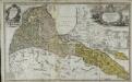
Per illustribus, generosissimis magnificis & excellentissimis dominis, dominis dvcatvvm Cvrlandiæ & Semgalliæ quatuor consiliariis supremis tabulam hanc dvcatvvm Cvrlandiæ & Semgalliæ geographicam
1 Karte : Kupferdruck ; 48 x 44 cm Barnickel Homännische Erben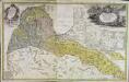
Per illustribus, generosissimis magnificis & excellentissimis dominis, dominis dvcatvvm Cvrlandiæ & Semgalliæ quatuor consiliariis supremis tabulam hanc dvcatvvm Cvrlandiæ & Semgalliæ geographicam
1 Karte : Kupferdruck ; 48 x 44 cm Barnickel Homännische Erben