Maps of Lithuania
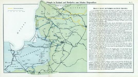
Nr. 7. Kämpfe in Kurland und Nordpolen zum Schutze Ostpreußens
Baltikum Weltkrieg <1914-1918>, Ostfront
Paasche's Frontenkarte, Nr.6. Der Krieg gegen Russland

Übersichtskarte von Ostpreußen, Kurland und den angrenzenden Gebieten
1 : 750000 Kuronsko k. u. k. Hof- und Universitätsbuchhandlung R. Lechner (W. Müller)
Prussia.
from Abraham Ortelius his epitome of the theater of the worlde / nowe latlye ... renewed and augmented ... by Micheal Coignet, mathematitian of Antwarpe.
Théatre de la guerre actuelle, en Allemagne, en Pologne et en Turquie. n4 (bis), Dantzig
1 : 900000 Chanlaire, Pierre Grégoire 1758-1817 Paris : chez l'auteur P. G. Chanlaire
Verwaltungsgebiet Ober Ost. Einteilung der Kreise und Eisenbahnlinien
Baltikum Oberost Weltkrieg <1914-1918> Eisenbahnnetz
Verwaltungsgebiet Ober Ost und geschlossene Sprachgebiete
Baltikum Oberost Weltkrieg <1914-1918>
Kalnuotumo ir nuotakumo Lietuvos
1 : 630000 Lotyšsko Matulionis, P. S. Schropp'sche Lehrmittel-Handlung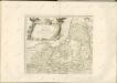


Regni Prussici Accuratissima Delineatio Edita Studio

[Litauen, Lettland]
Litauen, Lettland, ethnische Gruppe
(La Prusse)
1 : 4000000 Bruyset, Jean-Marie; Schneider, J. H.
Burgen-Karte von Preussen zur Zeit Deutschen Ordens
1 : 750000 Prusko Fischer, von Herwig, C. G.
Mapa narodowościowa polskich kresów północno-wschodnich i Litwy
1 : 1000000 Litva Machlejd, Jerzy Zaborski, Bogdan Gebethner & Wolff
Ethnographische Karte von Litauen
1 : 2000000 Litauen Ethnische Gruppe Kettler, Julius Iwan (red.)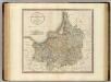
Prussia.
1 : 840000 Cary, John, ca. 1754-1835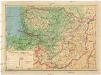
Lietuvos žemelapis
1 : 200000 Litva Spaudos fondas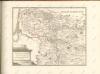

Karte der Eisenbahnen Deutschlands
1 : 700000 Nordost-Blatt Stich, Druck u. Verlag des lithographischen Instituts von Aug. Wehrt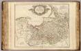
La Prusse.
1 : 720000 Robert de Vaugondy, Gilles, 1688-1766
Borussiae regnum cum adjacentibus regionibus mappa geographica delineat
1 : 1760000 Neuchâtel (Švýcarsko) Seutter, Matthäus Silbereisen, Andreas T.C. Lotter
Magnae Prussiae ducatus tabula
1 : 711000 Prusko Visscher, Nicolaus per Nicolaum Visscher
Carte des Königreichs Preussen
Suchodoletz, Johann Vladislaus von
REGNI PRUSSIAE accurata delineatio
1 : 2500000 Prusko
Prussiae Vera Descriptio., in: Theatrum orbis terrarum, S. 277.
1 Karte aus Atlas Ortelius, Abraham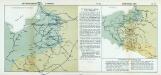
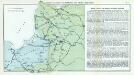
Nr. 18a. Die Winterschlacht in Masuren
Masuren Weltkrieg <1914-1918>, Ostfront
Prussiae Vera Descriptio. [Karte], in: Theatrum orbis terrarum, S. 372.
1 Karte aus Atlas Ortelius, Abraham Vrients, Jan Baptista
Prussia Accurate Descripta [Karte], in: Le théâtre du monde, ou, Nouvel atlas contenant les chartes et descriptions de tous les païs de la terre, Bd. 1, S. 97.
1 Karte aus Atlas Blaeu, Willem Janszoon und Blaeu, Joan Blaeu, Willem Janszoon