Maps of Eastern Equatoria
Carte internationale du monde au 1000,000 E
1 : 1000000 Súdán Sudan survey dept.
Sudan [Anglo-Egyptian] 1:250,000, Juba
Anglo-Egyptian Sudan / Survey Office. Sudan. Maṣlaḥat al-Misāḥah. [Southampton] : For D. Survey (WO & AM) by Ordnance Survey
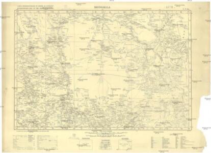
Sudan [Anglo-Egyptian] 1:250,000, Mongalla
Anglo-Egyptian Sudan / Survey Office. Sudan. Maṣlaḥat al-Misāḥah. [Southampton] : For D. Survey (WO & AM) by Ordnance Survey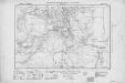
Africa 1:250,000, Sudan, Mt. Naita
[Africa. 1 : 250,000. Anglo-Egyptian Sudan]
Bahr el Ghazal
Bahr el Ghazal, TSGS 2102. Extract of Africa 1:1 million series; parts of sheets 77,78,85 & 86. Great Britain. General Staff. Topographical Section. [London] : [TSGS, War Office]
Sketch of a portion of the Lado Enclave, TSGS 2327
Sketch of a portion of the Lado Enclave, TSGS 2327. From material supplied by Capt. S. F. Newcombe RE." The Lado enclave was a part of southern Sudan briefly ceded to the Congo Free State." Great Britain. General Staff. Topographical Section. [London] : [TSGS, War Office]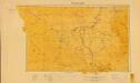
Sudan. Maṣlaḥat al-Misāḥah (1955)
[Sudan]. Sudan. Maṣlaḥat al-Misāḥah. Khartoum : Sudan Survey Department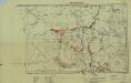
Southern Sudan (1951) Distribution of Population During Wet Season
Southern Sudan. Distribution of population during wet season. Corrected Nov. 1951. Topo. No. S. 918. Khartoum : Sudan Survey Dept.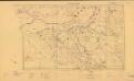
Sudan. Maṣlaḥat al-Misāḥah (1954)
Tribes [Sudan]. Sudan. Maṣlaḥat al-Misāḥah. Khartoum : Sudan Survey Department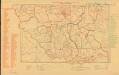
Parliamentary constituencies ― 1957 [Sudan]
Parliamentary constituencies ― 1957 [Sudan]. Sudan. Maṣlaḥat al-Misāḥah. Khartoum : Sudan Survey Department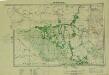
Southern Sudan (1951) Seasonal Cattle Movements
Southern Sudan. Seasonal cattle movements. Corrected Nov. 1951. Topo. No. S919. Khartoum : Sudan Survey Dept.
Countries In The Northern Tropical Regions of Africa.
Fullarton, A. & Co.
Map of the route explored by Captns. Speke & Grant from Zanzibar to Egypt : showing the outfall of the Nile from the Victoria Nyanza (Lake) and the various Negro territories discovered by them
1 : 5800000 Edward Stanford Ltd Edward Stanford
Abyssinia, surrounding countries.
1 : 6450000 Rand McNally and Company
Map of the egyptian Sudan
1 : 2253080 Súdán Intelligence branch, War Office
Liberia (1914)
Liberia, TSGS 2083. Great Britain. General Staff. Topographical Section. [London] : [TSGS, War Office]
Abissinie. Afrique 32.
1 : 1641836 Vandermaelen, Philippe, 1795-1869
Donga. Afrique 31.
1 : 1641836 Vandermaelen, Philippe, 1795-1869
A map of the Albert N'yanza : and of the routes leading to its discovery
1 : 2100000 Baker, Samuel White, Sir, 1821-1893 Macmillan & Co
The Anglo-Egyptian Sudan
1 : 3000000 Súdán Ordnance survey office
The Anglo-Egyptian Sudan
1 : 3000000 Súdán War Office
[Tok řeky Nilu]
1 : 7500000 Nil (řeka)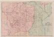
A map of Rhodesia divided into provinces and districts under the administration of the British South Africa Company
1 : 1000000 Edward Stanford Ltd Edward Stanford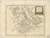
La Nubia ed Abissinia

Spezial-Karte von Afrika
1 : 4000000 Blatt 6 Habenicht, Hermann Perthes
Sudan and Ethiopia, Plate 87, V. IV
1 : 5000000 Bartholomew, John
Evangelische Mission im Kwango, Rep ZaireUebersichtsplan der Gemeinden und Aussenposten im Bezug zur Siedlungsdichte

Afrique Orientale.
1 : 7000000 Montemont, A.
Abessinien - Somaliländer
1 : 7500000 Etiopie Barich, Carl Justus Perthes