Maps of Ethiopia

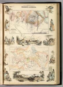
Countries In The Northern Tropical Regions of Africa.
Fullarton, A. & Co.
Abyssinia, surrounding countries.
1 : 6450000 Rand McNally and Company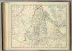
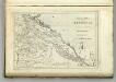
Upper Nubia and Abyssinia.
1 : 2854868 Johnston, W. & A.K.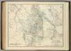
Upper Nubia and Abyssinia.
1 : 2854868 Johnston, Alexander Keith
Ethiopia. Pergamon World Atlas.
1 : 5000000 Polish Army Topography Service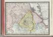
Upper Nubia and Habesh or Abyssina.
1 : 5000000 Rand McNally and Company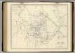
Nubia, Abyssinia.
1 : 2854868 Johnston, Alexander Keith, 1804-1871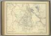
Upper Nubia and Abyssinia.
1 : 2854868 Johnston, Alexander Keith
Cestovatele Viléma Němce přehledná mapa Císařství habešského s poznámkami zoografickými a místopisnými
1 : 2070000 Etiopie Němec, Vilém Československá grafická unie
Map of the egyptian Sudan
1 : 2253080 Súdán Intelligence branch, War Office
Carte générale d'Abyssinie
1 : 1800000 dressée par M. le lieutenant de vaisseau Théophile Lefebvre pendant son voyage d'exploration en 1839, 40, 41, 42, 43 Paris : Arthus Bertrand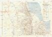
Seconda edizione della nuova carta dei domini e protettorati italiani nell' Eritrea e regioni limitrofe
1 : 1500000 Eritrea Ministero della guerra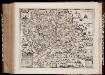
Habessinia seu Abassia, presbyteri Johannis regio perperam dicta ... / Jobi Lodolfi [cart.] ; Christianus Ludolfus J. Filius delineavit ex autographo Parentis
1 : 2400000 Annotatie: Origineel is Blad 211 in atlas factice Jobus Ludolphus 1624-1704; Christianus Ludolfus [Amsterdam] : [s.n.]
Carte de l'Abyssinie, du pays des Galla, de Choa et d'Ifat
1 : 2500000 dressée par Mrs. Combes et Tamisier dessinée par A. Vuillemin ; gravée par Massuet ; écrite par Martin ainé Paris : Desessart
Carte d'Abyssinie et des contrées adjacentes dressée partie d'après des observations faites sur les lieux par l'auteur, partie d'après les informations prises dans le pays en 1809 et 1810
1 : 5000000 par Henry Salt [S.l.] : [s.n.]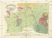
Geognostiche Karte von ost Sudan, umfaßsend dei Länder Kordofan, Nuba, Sennaar, Roserres, Faßsokl und el Pert nebst den angrenzenden Theilen von Dar Fur, Nubien, Ab eßsinien und den Galla Ländern
1 : 1800000 Etiopie E. Schweizerbart'schen Buchhandlung
Soudan égyptien & Abyssinie d'après divers documents
1 : 4000000 Amend, H Genève : imp. Noverraz & fils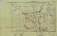
Southern Sudan (1951) Distribution of Population During Wet Season
Southern Sudan. Distribution of population during wet season. Corrected Nov. 1951. Topo. No. S. 918. Khartoum : Sudan Survey Dept.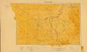
Sudan. Maṣlaḥat al-Misāḥah (1955)
[Sudan]. Sudan. Maṣlaḥat al-Misāḥah. Khartoum : Sudan Survey Department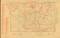
Parliamentary constituencies ― 1957 [Sudan]
Parliamentary constituencies ― 1957 [Sudan]. Sudan. Maṣlaḥat al-Misāḥah. Khartoum : Sudan Survey Department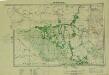
Southern Sudan (1951) Seasonal Cattle Movements
Southern Sudan. Seasonal cattle movements. Corrected Nov. 1951. Topo. No. S919. Khartoum : Sudan Survey Dept.
KARTE VON OST SUDAN
1 : 1800000 Dárfúr (Súdán) Russegger, Joseph E. Schweiyerbart'schen Buchhandlung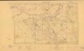
Sudan. Maṣlaḥat al-Misāḥah (1954)
Tribes [Sudan]. Sudan. Maṣlaḥat al-Misāḥah. Khartoum : Sudan Survey Department
Carta della colonia Eritrea coll'Abissinia : e regioni limitrofe tra il Nilo, Suakin e il Golfo d'Aden
1 : 4000000 Cora, Guido, 1851-1917 Fratelli Bocca
Abissinie. Afrique 32.
1 : 1641836 Vandermaelen, Philippe, 1795-1869
Jobi Ludolfi Habessinia seu Abassia, presbyteri Johannis regio
Etiopie Ludolf, Christian Habess, Gregorius
Liberia (1914)
Liberia, TSGS 2083. Great Britain. General Staff. Topographical Section. [London] : [TSGS, War Office]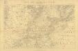
Carta dimostrativa della Etiopia (Sheet 5)
Carta dimostrativa della Etiopia, in 6 fogli e 2 aggiunte, alla scala di 1 : 100,000. Compilata dal Capitano ... Ethiopia de Chaurand, etc. [Rome]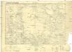
Carte internationale du monde au 1000,000 E
1 : 1000000 Súdán Sudan survey dept.