Maps of Komárom-Esztergom

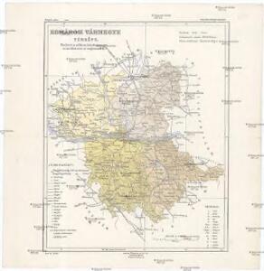
Komárom vármegye térképe
1 : 360000 Kogutowicz, Manó Magyar Földrajzi Intézet
Komorn 148, uit: Special-Karte von Mittel-Europa / nach amtlichen Quellen bearbeitet von W. Liebenow
1 : 300000 titelvariant: W. Liebenow's Mittel-Europa; Annotatie: Titel boven de bladen: W. Liebenow's Mittel-Europa Johannes Wilhelm Liebenow 1822-1897 Frankfurt a. M. : Ludwig Ravenstein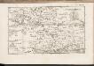
C. Comaromiensis
Ungarn Komitat Komorn (Ungarn)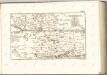
Komorner Comitat
1 : 290000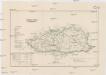
Komorner Comitat
1 : 288000 Komárno (Slovensko)
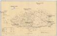
Acs und Totis.
from Spezialkarte der osterreichisch-ungarischen Monarchie.
III. vojenské mapování 4860/3
1 : 25000
Ács
1 : 75000 Maďarsko Vojenský zeměpisný ústav
Komárno
1 : 75000 Slovensko Vojenský zeměpisný ústav
Komárno a Nové Zámky
1 : 75000 Slovensko Vojenský zeměpisný ústav
Komárno a Nové Zámky
1 : 75000 Slovensko Vojenský zeměpisný ústav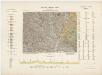
14 Zóna, XVIII Rovat, Érsekujvár és Komárom Vidéke, uit: [Geologische Specialkarte der im Reichsrathe vertretenen Königreiche und Länder der österreichisch-ungarischen Monarchie] / geologische Aufnahmen der königl. ung. Geologischen Anstalt
1 : 75000 Annotatie: Verantwoordelijkheidsvermelding in 1909 veranderd in: Königliche Ungarische Geologische Reichsanstalt; Sommige bladen in het Frans; Annotatie geografische gegevens: Coördinaten gebaseerd op nulmeridiaan van Ferro (Hierro) Königliche Ungarische Geologische Reichsanstalt; Königliche Ungarische Geologische Anstalt Budapest : [Königliche Ungarische Geologische Anstalt]
III. vojenské mapování 4960
1 : 75000
Ács und Totis
1 : 75000 Ács (Ungarn), Tata (Ungarn) Geripp: Feldw. Watterich. Terrain: Wachtmst. Edl. v. Palitschek
Neuhäusel und Komorn
1 : 75000 Komorn (Slowakei), Neuhäusel Geripp u. Terrain: J. Schulenburg
III. vojenské mapování 4860
1 : 75000
Neuhausel und Komorn.; Spezialkarte der osterreichisch-ungarischen Monarchie.
from Spezialkarte der osterreichisch-ungarischen Monarchie. Austro-Hungarian Monarchy. Militärgeographisches Institut.,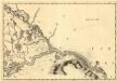
Raab - Neudorff
Mollova mapová sbírka Marsili, Luigi Ferdinando
Neszmely und Zsambek.
from Spezialkarte der osterreichisch-ungarischen Monarchie.
Mgy. Szolgyen und Gran.
from Spezialkarte der osterreichisch-ungarischen Monarchie.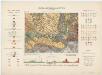
Zone 14, Kol. XIX, Umgebung von Magyarszölgyén und Párkány-Nána, uit: [Geologische Specialkarte der im Reichsrathe vertretenen Königreiche und Länder der österreichisch-ungarischen Monarchie] / geologische Aufnahmen der königl. ung. Geologischen Anstalt
1 : 75000 Annotatie: Verantwoordelijkheidsvermelding in 1909 veranderd in: Königliche Ungarische Geologische Reichsanstalt; Sommige bladen in het Frans; Annotatie geografische gegevens: Coördinaten gebaseerd op nulmeridiaan van Ferro (Hierro) Königliche Ungarische Geologische Reichsanstalt; Königliche Ungarische Geologische Anstalt Budapest : [Königliche Ungarische Geologische Anstalt]
Radvaň n. Dunajom
1 : 75000 Maďarsko Vojenský zeměpisný ústav
Zsámbék
1 : 75000 Maďarsko Vojenský zeměpisný ústav
Dunaradvány a Zsámbék
1 : 75000 Maďarsko Vojenský zeměpisný ústav
Parkan
1 : 75000 Maďarsko Vojenský zeměpisný ústav
Parkan
1 : 75000 Maďarsko Vojenský zeměpisný ústav
III. vojenské mapování 4961
1 : 75000
III. vojenské mapování 4861
1 : 75000