Maps of Esztergomi járás

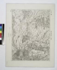
Mgy. Szolgyen und Gran.
from Spezialkarte der osterreichisch-ungarischen Monarchie.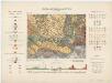
Zone 14, Kol. XIX, Umgebung von Magyarszölgyén und Párkány-Nána, uit: [Geologische Specialkarte der im Reichsrathe vertretenen Königreiche und Länder der österreichisch-ungarischen Monarchie] / geologische Aufnahmen der königl. ung. Geologischen Anstalt
1 : 75000 Annotatie: Verantwoordelijkheidsvermelding in 1909 veranderd in: Königliche Ungarische Geologische Reichsanstalt; Sommige bladen in het Frans; Annotatie geografische gegevens: Coördinaten gebaseerd op nulmeridiaan van Ferro (Hierro) Königliche Ungarische Geologische Reichsanstalt; Königliche Ungarische Geologische Anstalt Budapest : [Königliche Ungarische Geologische Anstalt]
III. vojenské mapování 4861
1 : 75000
Mgy. Szölgyén und Gran
1 : 75000 Svodin, Esztergom Schrift und Gerippe v. Oberlt. Charlemont. Terrainschraffirung v. Lieut. Sied
Parkan
1 : 75000 Maďarsko Vojenský zeměpisný ústav
Parkan
1 : 75000 Maďarsko Vojenský zeměpisný ústav
III. vojenské mapování 4861/3
1 : 25000
III. vojenské mapování 4861/2
1 : 25000
III. vojenské mapování 4861/4
1 : 25000
III. vojenské mapování 4861/1
1 : 25000
Neszmély
1 : 25000 Maďarsko M. Kir. Állami Térképszeti Intézet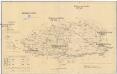
Komorner Comitat
1 : 290000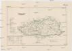
Komorner Comitat
1 : 288000 Komárno (Slovensko)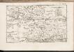
C. Comaromiensis
Ungarn Komitat Komorn (Ungarn)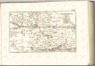

Leva und Sallo. (Ungarn)
from Spezialkarte der osterreichisch-ungarischen Monarchie.
Neszmely und Zsambek.
from Spezialkarte der osterreichisch-ungarischen Monarchie.
Nograd und Waitzen.
from Spezialkarte der osterreichisch-ungarischen Monarchie.
Radvaň n. Dunajom
1 : 75000 Maďarsko Vojenský zeměpisný ústav
Zsámbék
1 : 75000 Maďarsko Vojenský zeměpisný ústav
Dunaradvány a Zsámbék
1 : 75000 Maďarsko Vojenský zeměpisný ústav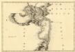
Sectio. IV, Barkan - Sz. André
Mollova mapová sbírka Marsili, Luigi Ferdinando
III. vojenské mapování 4961
1 : 75000
Pilis hegység
1 : 50000 M. Kir. Állami Térképeszet
Nógrád a Vácov
1 : 75000 Maďarsko Kartografické odd. při Mi. nár. obrany
A nagysallói csata vázlata (1849 april 19-én)
Ungarn Schlacht bei Nagy-Sarlo Ungarn / Revolution <1848-1849>
[Gradkartenblatt]
1 : 25000 Maďarsko Vojenský zeměpisný ústav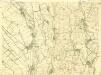
III. vojenské mapování 4761/4
1 : 25000
III. vojenské mapování 4862/1
1 : 25000