Maps of Ochakiv

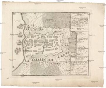
Plan veritable de la fameuse forteresse d'Oczakow
Du Chaffat, Antoine

Ichnographia munitissimae arcis Otzakoff quae Ao 1737. die 3 iulii auspiciis supremi campi mareschalli comitis de Münnich ab exercitu Russorum vi occupata
1 : 3700 Seutter, Matthäus â Matth. Seuttero
Carte der Landung und Attaque der Türken bei Kinburn den 12ten Oct. 1787
1 : 180000 Černé moře-oblast Trattner, Johann Thomas Thomas Edlen v. Trattnern k.k. Hofbuchdruck.
Carte der Landung und Attaque der Türken bei Kinburn den 12ten Oct. 1787
1 : 180000 Černé moře-oblast Thomas Edlen v[on] Trattner
Confluent et embouchure du Bog et du Dniéper
1 : 170000 Dněpr Benedicti, Hieronymus
Confluent et embouchure du Bog et du Dniéper
1 Karte : Kupferdruck ; 22 x 63 cm Clerc; Dupuis Froullé
Confluent et embouchure du Bog et du Dniéper / gravé à Vienne par H. Benedicti
1 : 170000 1 Karte : Kupferdruck ; 22 x 63 cm Maire, François Joseph [F. J. Maire]
TRACTVS | BORYSTHENIS | Vulgo DNIEPR et NIEPR dicti, | à CHORTIKA OSTRO ad Urbem OCZAKOW | ubi in PONTVM EUXINUM | se exonerat.
[Amsterdam : Joan Blaeu]
[Dnjepr-Mündung]
1 Karte : Kupferdruck ; 18 x 13 cm [Trattner]
Charte der Lage von Cherson, Odessa und Bender und der Ausflüsse des Dnestr's und Dnjepr's
Cherson (Ukrajina)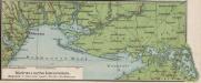
Südrussische Limanküste
1 : 2000000 Ukraine, Schwarzmeerküste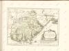

[Dniepr Fluvius A Ptolomeo Borystenes Vocatus] [Karte, Teil 2], in: Novus Atlas, das ist, Weltbeschreibung, Bd. 1, S. 70.
1 Karte aus Atlas Blaeu, Joan Blaeu, Willem Janszoon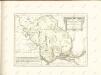

Campus Inter Bohum et Borystenem [und] Campus Inter Bohum & Borystenem [Karte, Teil 2], in: Theatrum orbis terrarum, sive, Atlas novus, Bd. 1, S. 93.
1 Karte aus Atlas Blaeu, Joan Blaeu, Willem Janszoon
Bessarabia. Podolia. Lithuasia
Mollova mapová sbírka Hoffmann, Johannes Hoffmann, Johann
Special-Karte des Kriegsschauplatzes in Süd-Russland
1 : 420000 Rusko jižní Handtke, Friedrich C. Flemming
Tractus Borysthenis Vulgo Dniepr et Niepr dicti, à Kiovia ad Urbum Oczakow ubi in pontum Euxinum se exonerat. [Karte, Teil 3], in: Novus atlas absolutissimus, Bd. 1, S. 73.
1 Karte aus Atlas Janssonius Offizin
[Dniepr Fluvius A Ptolomeo Borystenes Vocatus] [Karte, Teil 1], in: Le théâtre du monde, ou, Nouvel atlas contenant les chartes et descriptions de tous les païs de la terre, Bd. 1, S. 83.
1 Karte aus Atlas Blaeu, Willem Janszoon und Blaeu, Joan Blaeu, Willem Janszoon
Post Karte von der Halbinsel Taurien oder Krim / H. Benedicti sc
1 : 1100000 1 Karte : Kupferdruck ; 27 x 41 cm Benedicti, Hieronymus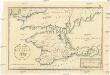
Post Karte von der Halbinsel Taurien oder Krim
1 : 1000000 Krym (Ukrajina) Benedicti, Hieronymus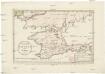
Post Karte von der Halbinsel Taurien oder Krim
1 : 1000000 Krym (Ukrajina) Benedicti, Hieronymus
Die Krymm
1 : 1680000 Feodosija (Ukrajina) Flemming, Karl druck u. Verlag v. C. Flemming
Die Krymm
1 : 680000 Anapa (Rusko) Flemming, C. C. Flemming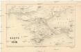
Karte der Krim
1 : 1484000 Krym (Ukrajina) Leopold Sommer
Tractus Borysthenis vulgo Dniepr et Niepr dicti, a Kiovia ad urbum Oczakow ubi in Pontum Euxinum se exonerat
1 : 462500 Dněpr Schenk, Pieter Valk, Gerhard P. Schenk et G. Valk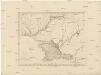
Karte Tauriens oder der Halbinsel Krim und der westlichen Nogayischen Tatarei
1 : 760000 Krym (Ukrajina) Schmidt, Jacob Friedrich Schraembl, Franz Anton F.A. Schraembl
Karte Tauriens oder der Halbinsel Krim und der westlichen nogayischen Tatarei
1 : 763000 Krym (Ukrajina) Schmidt, Jacob Friedrich Schraembl, Franz Anton F.A. Schraembl