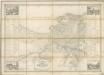
Maps of Odessa

Transnistrien 1989. Ethnische Zusammensetzung der Bevölkerung - Moldauer (Rumänen)
Transnistrien ethnische Gruppe, Moldauer Hofinger, Veronika
Trigonometrisk grunnlag, vedlegg 65, 2-5: Grunnlagspunkter for Struves meridianbue fra Bessarabia og Volhynia
1 : 200000 de Tenner
Republik Moldau 1989. Ethnische Zusammensetzung der Bevölkerung - Bulgaren
Moldawien ethnische Gruppe, Bulgaren Hofinger, Veronika
Republik Moldau 1989. Ethnische Zusammensetzung der Bevölkerung - Gagausen
Moldawien ethnische Gruppe, Gagausen Hofinger, Veronika
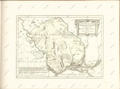
TRACTVS | BORYSTHENIS | Vulgo DNIEPR et NIEPR dicti, | à CHORTIKA OSTRO ad Urbem OCZAKOW | ubi in PONTVM EUXINUM | se exonerat.
[Amsterdam : Joan Blaeu]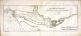
Confluent et embouchure du Bog et du Dniéper
1 Karte : Kupferdruck ; 22 x 63 cm Clerc; Dupuis Froullé
Confluent et embouchure du Bog et du Dniéper / gravé à Vienne par H. Benedicti
1 : 170000 1 Karte : Kupferdruck ; 22 x 63 cm Maire, François Joseph [F. J. Maire]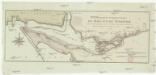
Confluent et embouchure du Bog et du Dniéper
1 : 170000 Dněpr Benedicti, Hieronymus
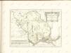
Plan okrestnostej Voznesenska
1 : 29200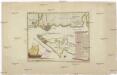
Carte der Landung und Attaque der Türken bei Kinburn den 12ten Oct. 1787
1 : 180000 Černé moře-oblast Trattner, Johann Thomas Thomas Edlen v. Trattnern k.k. Hofbuchdruck.
Carte der Landung und Attaque der Türken bei Kinburn den 12ten Oct. 1787
1 : 180000 Černé moře-oblast Thomas Edlen v[on] Trattner
Action bey der Prutt zwischen denen Türcken und Moscowiten, 1711
1 : 13000 Annotatie: Uit: Theatrum Europaeum ..., Bd. 19, oorspronkelijk verschenen 1723; Annotatie geografische gegevens: West boven [Frankfurt am Main : Merian]
Lambert-Cholesky sheet 5273 (Sultăneşti)
1 : 20000 Romanian military topographic map sheet under Lambert-Cholensky projection Serviciul Geografic al Armatei geo-spatial.org Serviciul Geografic al Armatei
Lambert-Cholesky sheet 5369 (Pogoneşti)
1 : 20000 Romanian military topographic map sheet under Lambert-Cholensky projection Institutul Geografic Militar geo-spatial.org Institutul Geografic Militar
Lambert-Cholesky sheet 5368 (Stălineşti)
1 : 20000 Romanian military topographic map sheet under Lambert-Cholensky projection Institutul Geografic Militar geo-spatial.org Institutul Geografic Militar
Lambert-Cholesky sheet 5271 (Podoleni de Sus)
1 : 20000 Romanian military topographic map sheet under Lambert-Cholensky projection Serviciul Geografic al Armatei geo-spatial.org Serviciul Geografic al Armatei
Lambert-Cholesky sheet 5367 (Leova)
1 : 20000 Romanian military topographic map sheet under Lambert-Cholensky projection Serviciul Geografic al Armatei geo-spatial.org Serviciul Geografic al Armatei
Lambert-Cholesky sheet 5270 (Drănceni)
1 : 20000 Romanian military topographic map sheet under Lambert-Cholensky projection Serviciul Geografic al Armatei geo-spatial.org Serviciul Geografic al Armatei
Lambert-Cholesky sheet 5366 (Vetrişoaia)
1 : 20000 Romanian military topographic map sheet under Lambert-Cholensky projection Serviciul Geografic al Armatei geo-spatial.org Serviciul Geografic al Armatei
Lambert-Cholesky sheet 5269 (Huși)
1 : 20000 Romanian military topographic map sheet under Lambert-Cholensky projection Direcția Topografică Militară geo-spatial.org Direcția Topografică Militară
Lambert-Cholesky sheet 5365 (Fălciu)
1 : 20000 Romanian military topographic map sheet under Lambert-Cholensky projection Serviciul Geografic al Armatei geo-spatial.org Serviciul Geografic al Armatei
Lambert-Cholesky sheet 5268 (Şchiopeni)
1 : 20000 Romanian military topographic map sheet under Lambert-Cholensky projection Direcția Topografică Militară geo-spatial.org Direcția Topografică Militară
Lambert-Cholesky sheet 5267 (Grumezoaia)
1 : 20000 Romanian military topographic map sheet under Lambert-Cholensky projection Direcția Topografică Militară geo-spatial.org Direcția Topografică Militară
Lambert-Cholesky sheet 5266 (Guşăţei)
1 : 20000 Romanian military topographic map sheet under Lambert-Cholensky projection Serviciul Geografic al Armatei geo-spatial.org Serviciul Geografic al Armatei
Lambert-Cholesky sheet 5265 (Bozia)
1 : 20000 Romanian military topographic map sheet under Lambert-Cholensky projection Serviciul Geografic al Armatei geo-spatial.org Serviciul Geografic al Armatei
Lambert-Cholesky sheet 5264 (Murgeni)
1 : 20000 Romanian military topographic map sheet under Lambert-Cholensky projection Serviciul Geografic al Armatei geo-spatial.org Serviciul Geografic al Armatei
Lambert-Cholesky sheet 5263 (Blăgeşti)
1 : 20000 Romanian military topographic map sheet under Lambert-Cholensky projection Serviciul Geografic al Armatei geo-spatial.org Serviciul Geografic al Armatei
Belagerung der türkischen Festung Bender ... am 14./15. November 1789 ...
1 Karte : Kupferdruck ; 12 x 17 cm [Trattner]