Maps of Bilhorod-Dnistrovskyi Raion

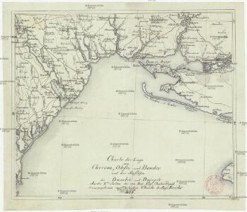
Charte der Lage von Cherson, Odessa und Bender und der Ausflüsse des Dnestr's und Dnjepr's
Cherson (Ukrajina)
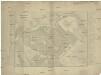
TRACTVS | BORYSTHENIS | Vulgo DNIEPR et NIEPR dicti, | à CHORTIKA OSTRO ad Urbem OCZAKOW | ubi in PONTVM EUXINUM | se exonerat.
[Amsterdam : Joan Blaeu]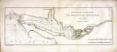
Confluent et embouchure du Bog et du Dniéper
1 Karte : Kupferdruck ; 22 x 63 cm Clerc; Dupuis Froullé
Confluent et embouchure du Bog et du Dniéper
1 : 170000 Dněpr Benedicti, Hieronymus
Carte der Landung und Attaque der Türken bei Kinburn den 12ten Oct. 1787
1 : 180000 Černé moře-oblast Trattner, Johann Thomas Thomas Edlen v. Trattnern k.k. Hofbuchdruck.
Carte der Landung und Attaque der Türken bei Kinburn den 12ten Oct. 1787
1 : 180000 Černé moře-oblast Thomas Edlen v[on] Trattner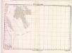
Lambert-Cholesky sheet 6154 (Zalivi Baba Hasan)
1 : 20000 Romanian military topographic map sheet under Lambert-Cholensky projection Serviciul Geografic al Armatei geo-spatial.org Serviciul Geografic al Armatei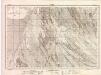
Lambert-Cholesky sheet 6054 (Letea)
1 : 20000 Romanian military topographic map sheet under Lambert-Cholensky projection Direcția Topografică Militară geo-spatial.org Direcția Topografică Militară
Belagerung der türkischen Festung Bender ... am 14./15. November 1789 ...
1 Karte : Kupferdruck ; 12 x 17 cm [Trattner]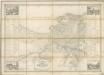
Plan Goroda Odessy
Plan goroda Odessy sostavlennyj v 1843 godu
1 : 7600 Oděsa (Ukrajina) Klenov, D.
Ichnographia munitissimae arcis Otzakoff quae Ao 1737. die 3 iulii auspiciis supremi campi mareschalli comitis de Münnich ab exercitu Russorum vi occupata
1 : 3700 Seutter, Matthäus â Matth. Seuttero

Plan veritable de la fameuse forteresse d'Oczakow
Du Chaffat, Antoine
Special-Karte des Kriegsschauplatzes in Süd-Russland
1 : 420000 Rusko jižní Handtke, Friedrich C. Flemming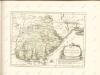
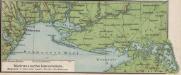
Südrussische Limanküste
1 : 2000000 Ukraine, Schwarzmeerküste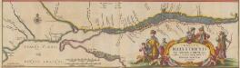
Tractus Borysthenis Vulgo Dniepr et Niepr dicti, à Kiovia ad Urbum Oczakow ubi in pontum Euxinum se exonerat. [Karte, Teil 3], in: Novus atlas absolutissimus, Bd. 1, S. 73.
1 Karte aus Atlas Janssonius Offizin
Bessarabia. Podolia. Lithuasia
Mollova mapová sbírka Hoffmann, Johannes Hoffmann, Johann
[Dnjepr-Mündung]
1 Karte : Kupferdruck ; 18 x 13 cm [Trattner]
Bocche del Danubio
1 : 483000 Dunaj (Rumunsko a Ukrajina : řeka : delta)
Plan des tapfern Angriffs und vollkommenen Sieges der russisch-kayserlichen Waffen über die Turkische und Tatarische Arméé an der Large in der Moldau den 7. Iuly 1770
1 : 40000 Moldavsko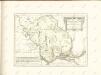

Bielcy, Kisziniew, Jassi
1 : 750000 Jasy (Rumunsko) Czerny, Eduard K. u. k. Militärgeographisches Institut
Bielcy, Kisziniew, Jassi
1 : 750000 Jasy (Rumunsko) K. k. militär-geographisches Institut
Trigonometrisk grunnlag, vedlegg 65, 2-5: Grunnlagspunkter for Struves meridianbue fra Bessarabia og Volhynia
1 : 200000 de Tenner
Confluent et embouchure du Bog et du Dniéper / gravé à Vienne par H. Benedicti
1 : 170000 1 Karte : Kupferdruck ; 22 x 63 cm Maire, François Joseph [F. J. Maire]
Generalkarte von Zentraleuropa

Lambert-Cholesky sheet 6053 (Grindu Kirila)
1 : 20000 Romanian military topographic map sheet under Lambert-Cholensky projection Serviciul Geografic al Armatei geo-spatial.org Serviciul Geografic al Armatei