Maps of Hola Prystan Raion

[Dnjepr-Mündung]
1 Karte : Kupferdruck ; 18 x 13 cm [Trattner]
TRACTVS | BORYSTHENIS | Vulgo DNIEPR et NIEPR dicti, | à CHORTIKA OSTRO ad Urbem OCZAKOW | ubi in PONTVM EUXINUM | se exonerat.
[Amsterdam : Joan Blaeu]
Confluent et embouchure du Bog et du Dniéper / gravé à Vienne par H. Benedicti
1 : 170000 1 Karte : Kupferdruck ; 22 x 63 cm Maire, François Joseph [F. J. Maire]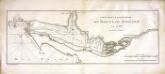
Confluent et embouchure du Bog et du Dniéper
1 Karte : Kupferdruck ; 22 x 63 cm Clerc; Dupuis Froullé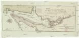
Confluent et embouchure du Bog et du Dniéper
1 : 170000 Dněpr Benedicti, Hieronymus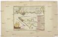
Carte der Landung und Attaque der Türken bei Kinburn den 12ten Oct. 1787
1 : 180000 Černé moře-oblast Trattner, Johann Thomas Thomas Edlen v. Trattnern k.k. Hofbuchdruck.
Carte der Landung und Attaque der Türken bei Kinburn den 12ten Oct. 1787
1 : 180000 Černé moře-oblast Thomas Edlen v[on] Trattner
Ichnographia munitissimae arcis Otzakoff quae Ao 1737. die 3 iulii auspiciis supremi campi mareschalli comitis de Münnich ab exercitu Russorum vi occupata
1 : 3700 Seutter, Matthäus â Matth. Seuttero

Plan veritable de la fameuse forteresse d'Oczakow
Du Chaffat, Antoine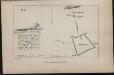
Plan Aleškovskoj Siči
Ukraine Saporoschje (Region) Saporoger Kosaken
Special-Karte des Kriegsschauplatzes in Süd-Russland
1 : 420000 Rusko jižní Handtke, Friedrich C. Flemming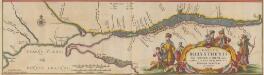
Tractus Borysthenis Vulgo Dniepr et Niepr dicti, à Kiovia ad Urbum Oczakow ubi in pontum Euxinum se exonerat. [Karte, Teil 3], in: Novus atlas absolutissimus, Bd. 1, S. 73.
1 Karte aus Atlas Janssonius Offizin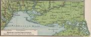
Südrussische Limanküste
1 : 2000000 Ukraine, Schwarzmeerküste
[Dniepr Fluvius A Ptolomeo Borystenes Vocatus] [Karte, Teil 1], in: Le théâtre du monde, ou, Nouvel atlas contenant les chartes et descriptions de tous les païs de la terre, Bd. 1, S. 83.
1 Karte aus Atlas Blaeu, Willem Janszoon und Blaeu, Joan Blaeu, Willem Janszoon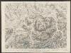
Campus Inter Bohum et Borystenem [und] Campus Inter Bohum & Borystenem [Karte, Teil 2], in: Theatrum orbis terrarum, sive, Atlas novus, Bd. 1, S. 93.
1 Karte aus Atlas Blaeu, Joan Blaeu, Willem Janszoon
Bessarabia. Podolia. Lithuasia
Mollova mapová sbírka Hoffmann, Johannes Hoffmann, Johann
Charte der Lage von Cherson, Odessa und Bender und der Ausflüsse des Dnestr's und Dnjepr's
Cherson (Ukrajina)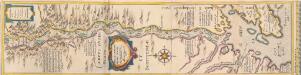
[Dniepr Fluvius A Ptolomeo Borystenes Vocatus] [Karte, Teil 2], in: Novus Atlas, das ist, Weltbeschreibung, Bd. 1, S. 70.
1 Karte aus Atlas Blaeu, Joan Blaeu, Willem Janszoon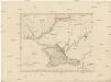
Karte Tauriens oder der Halbinsel Krim und der westlichen Nogayischen Tatarei
1 : 760000 Krym (Ukrajina) Schmidt, Jacob Friedrich Schraembl, Franz Anton F.A. Schraembl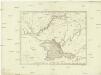
Karte Tauriens oder der Halbinsel Krim und der westlichen nogayischen Tatarei
1 : 763000 Krym (Ukrajina) Schmidt, Jacob Friedrich Schraembl, Franz Anton F.A. Schraembl
Tavrie
Azovské moře-oblast (Ukrajina a Rusko)
Scythia Europaea Et Asiatica Cum Chersoneso Taurica Ante et Post Christum Natum ad Seculum V
1 : 6500000 Mollova mapová sbírka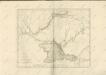

Theatrum belli Ao. MDCCXXXVII a milite Augustae Russorum Imperatricis adversus Turcas Tattarosque ge
1 : 1900000 1 Karte : Kupferdruck ; 46 x 65 cm apud R. & I. Ottens
Gouv. 24. Woronesh, 28. Slobodsk Ukraïne
1 : 2200000 1 Karte : Lithographie ; 20 x 26 cm Schlieben, W.E.A. von [Georg Joachim Göschen]
I governi di Moscovia, di Niz-Novogorod e di Kazan
1 : 4900000 1 Karte : Kupferdruck ; 22 x 31 cm Presso Pazzini Carli
Theatrum belli a.o MDCCXXXVII & XXXVIII a milite augustae russorum imperatricis adversus Turcas Tatt
1 : 2000000 1 Karte : Kupferdruck ; 48 x 66 cm apud Joan Block

![[Dnjepr-Mündung]](https://images-2.georeferencer.com/images/iiif/828992034504/full/,300/0/native.jpg)

