Maps of Crimea
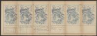
[Dniepr Fluvius A Ptolomeo Borystenes Vocatus] [Karte, Teil 1], in: Le théâtre du monde, ou, Nouvel atlas contenant les chartes et descriptions de tous les païs de la terre, Bd. 1, S. 83.
1 Karte aus Atlas Blaeu, Willem Janszoon und Blaeu, Joan Blaeu, Willem Janszoon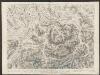
Campus Inter Bohum et Borystenem [und] Campus Inter Bohum & Borystenem [Karte, Teil 2], in: Theatrum orbis terrarum, sive, Atlas novus, Bd. 1, S. 93.
1 Karte aus Atlas Blaeu, Joan Blaeu, Willem Janszoon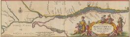
Tractus Borysthenis Vulgo Dniepr et Niepr dicti, à Kiovia ad Urbum Oczakow ubi in pontum Euxinum se exonerat. [Karte, Teil 3], in: Novus atlas absolutissimus, Bd. 1, S. 73.
1 Karte aus Atlas Janssonius Offizin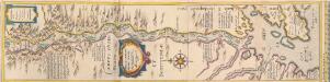
[Dniepr Fluvius A Ptolomeo Borystenes Vocatus] [Karte, Teil 2], in: Novus Atlas, das ist, Weltbeschreibung, Bd. 1, S. 70.
1 Karte aus Atlas Blaeu, Joan Blaeu, Willem Janszoon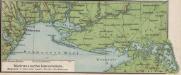
Südrussische Limanküste
1 : 2000000 Ukraine, Schwarzmeerküste
[Dnjepr-Mündung]
1 Karte : Kupferdruck ; 18 x 13 cm [Trattner]
[Neu Russland]
1 Karte : Kupferdruck ; 18 x 13 cm [Trattner]
[Taurien oder Crim]
1 Karte : Kupferdruck ; 18 x 13 cm [Trattner]
Porogen des Dnjepr
1 : 2400000 Dnjepr Flusslauf, Stromschnelle
Confluent et embouchure du Bog et du Dniéper / gravé à Vienne par H. Benedicti
1 : 170000 1 Karte : Kupferdruck ; 22 x 63 cm Maire, François Joseph [F. J. Maire]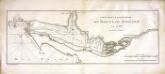
Confluent et embouchure du Bog et du Dniéper
1 Karte : Kupferdruck ; 22 x 63 cm Clerc; Dupuis Froullé
TRACTVS | BORYSTHENIS | Vulgo DNIEPR et NIEPR dicti, | à CHORTIKA OSTRO ad Urbem OCZAKOW | ubi in PONTVM EUXINUM | se exonerat.
[Amsterdam : Joan Blaeu]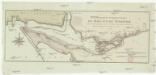
Confluent et embouchure du Bog et du Dniéper
1 : 170000 Dněpr Benedicti, Hieronymus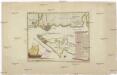
Carte der Landung und Attaque der Türken bei Kinburn den 12ten Oct. 1787
1 : 180000 Černé moře-oblast Trattner, Johann Thomas Thomas Edlen v. Trattnern k.k. Hofbuchdruck.
Carte der Landung und Attaque der Türken bei Kinburn den 12ten Oct. 1787
1 : 180000 Černé moře-oblast Thomas Edlen v[on] Trattner
Ichnographia munitissimae arcis Otzakoff quae Ao 1737. die 3 iulii auspiciis supremi campi mareschalli comitis de Münnich ab exercitu Russorum vi occupata
1 : 3700 Seutter, Matthäus â Matth. Seuttero
Plan Novoj Siči
Ukraine Saporoschje (Region) Saporoger Kosaken

Plan veritable de la fameuse forteresse d'Oczakow
Du Chaffat, Antoine
Plan Kamenskoj Siči
Ukraine Saporoschje (Region) Saporoger Kosaken
Plan Čortomlyckoj Siči
Ukraine Saporoschje (Region) Saporoger Kosaken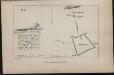
Plan Aleškovskoj Siči
Ukraine Saporoschje (Region) Saporoger Kosaken
TRACTVS | BORYSTHENIS | Vulgo DNIEPR et NIEPR dicti, | à BOVZIN usque ad CHORTYCA OSTROW.
Amstelædami, Excud. Ioannes Blaeu.
Plan okrestnostej Voznesenska
1 : 29200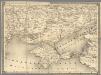
14. Cherson
1 : 1400000 Schubert, Friedrich Theodor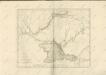

A map of the lesser Tartary / done from the original, published by the Imperial Academy of Sciences
1 : 1700000 1 Karte : Kupferdruck ; 39 x 45 cm Senex, John [Iohn Senex]
Theatrum belli Ao. MDCCXXXVII a milite Augustae Russorum Imperatricis adversus Turcas Tattarosque ge
1 : 1900000 1 Karte : Kupferdruck ; 46 x 65 cm apud R. & I. Ottens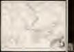
Theatrum belli a.o MDCCXXXVII & XXXVIII a milite augustae russorum imperatricis adversus Turcas Tatt
1 : 2000000 1 Karte : Kupferdruck ; 48 x 66 cm apud Joan Block
![[Dniepr Fluvius A Ptolomeo Borystenes Vocatus] [Karte, Teil 1], in: Le théâtre du monde, ou, Nouvel atlas contenant les chartes et descriptions de tous les païs de la terre, Bd. 1, S. 83.](https://images-2.georeferencer.com/images/iiif/611993458237/full/,300/0/native.jpg)

