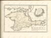
Maps of Crimea

Scythia Europaea Et Asiatica Cum Chersoneso Taurica Ante et Post Christum Natum ad Seculum V
1 : 6500000 Mollova mapová sbírka
Karte der deutschen Siedlungen in Neu (Süd)-Rußland
Russland Russland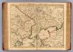
Theatre de la guerre, Petite Tartarie, Crimee, Mer Noire.
1 : 1250000 L'Isle, Guillaume de, 1675-1726
Russia in Europe Part VIII with index map.
1 : 2250000 Society for the Diffusion of Useful Knowledge (Great Britain)
Partie, Russie. Europe 22.
1 : 1641836 Vandermaelen, Philippe, 1795-1869
Cimmeria, quae Postea Scythia Europaea Seu Parva Scythia / Ex Conatibus Geographicis Gulielmi Sanson
1 : 3000000 1 Karte : Kupferdruck ; 38 x 48 cm Sanson, Guillaume Apud I. Covens et C. Mortier
Theatrum belli Ao. MDCCXXXVII a milite Augustae Russorum Imperatricis adversus Turcas Tattarosque ge
1 : 1900000 1 Karte : Kupferdruck ; 46 x 65 cm apud R. & I. Ottens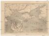
Bojiště černomořské
Krym (Ukrajina)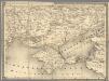
14. Cherson
1 : 1400000 Schubert, Friedrich Theodor
[Taurien]
Taurien (Gouvernement) Verwaltungsgliederung
Theatrum belli a.o MDCCXXXVII & XXXVIII a milite augustae russorum imperatricis adversus Turcas Tatt
1 : 2000000 1 Karte : Kupferdruck ; 48 x 66 cm apud Joan Block
A map of the lesser Tartary / done from the original, published by the Imperial Academy of Sciences
1 : 1700000 1 Karte : Kupferdruck ; 39 x 45 cm Senex, John [Iohn Senex]
Charte der Kriegs Operationen am Donn u: Dnieper Ihro Russisch Kayserl. Maiestaet glorieusen Armeen
1 : 1700000 1 Karte : Kupferdruck ; 38 x 44 cm (ganzes Blatt 54 x 64 cm) Seutter, Matthäus zu haben bey Matthaeus Seutter der röm: kayserl: u: königl: cathol: Majest: Geogr
Tavrie
Azovské moře-oblast (Ukrajina a Rusko)
Die Krymm [i.e. Krim]
1 : 1680000 Druck u. Verlag v. C. Flemming
Karte Tauriens oder der Halbinsel Krim und der westlichen Nogayischen Tatarei
1 : 760000 Krym (Ukrajina) Schmidt, Jacob Friedrich Schraembl, Franz Anton F.A. Schraembl
Karte Tauriens oder der Halbinsel Krim und der westlichen nogayischen Tatarei
1 : 763000 Krym (Ukrajina) Schmidt, Jacob Friedrich Schraembl, Franz Anton F.A. Schraembl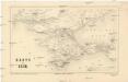
Karte der Krim
1 : 1484000 Krym (Ukrajina) Leopold Sommer
Die Krymm
1 : 1680000 Feodosija (Ukrajina) Flemming, Karl druck u. Verlag v. C. Flemming
Die Krymm
1 : 680000 Anapa (Rusko) Flemming, C. C. Flemming
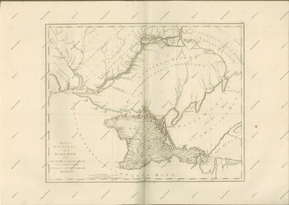
Carte du gouvernement de Tauride comprenant la Krimée et les pays voisins
1 : 1150000 Krym (Ukrajina) par les freres Lotter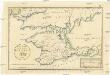
Post Karte von der Halbinsel Taurien oder Krim
1 : 1000000 Krym (Ukrajina) Benedicti, Hieronymus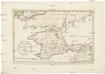
Post Karte von der Halbinsel Taurien oder Krim
1 : 1000000 Krym (Ukrajina) Benedicti, Hieronymus
Post Karte von der Halbinsel Taurien oder Krim / H. Benedicti sc
1 : 1100000 1 Karte : Kupferdruck ; 27 x 41 cm Benedicti, Hieronymus
[Dniepr Fluvius A Ptolomeo Borystenes Vocatus] [Karte, Teil 1], in: Le théâtre du monde, ou, Nouvel atlas contenant les chartes et descriptions de tous les païs de la terre, Bd. 1, S. 83.
1 Karte aus Atlas Blaeu, Willem Janszoon und Blaeu, Joan Blaeu, Willem Janszoon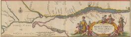
Tractus Borysthenis Vulgo Dniepr et Niepr dicti, à Kiovia ad Urbum Oczakow ubi in pontum Euxinum se exonerat. [Karte, Teil 3], in: Novus atlas absolutissimus, Bd. 1, S. 73.
1 Karte aus Atlas Janssonius Offizin
Obščij plan zaporožskich vladěnīj
Ukraine Saporoschje (Region) Saporoger Kosaken
Carte de la Mer d'Azof et d'une partie de la Mer Noire / levée en 1774 par Monsieur Kinsbergen, Cap
1 : 1600000 1 Karte : Kupferdruck ; 19 x 45 cm Kinsbergen, Jan Hendrik van Froullé