Maps of Israel
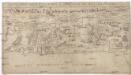
Sitvs terre sancte ivxta nvmerv[m] filior[um] Israel per apices sev pv[n]cta divisvs
Palestina
[Kaart], uit: Bartholomew's quarter-inch map of Palestine with orographical colouring
1 : 253440 Annotatie: Met 2 profielen van Palestina (OW en NZ); Met historische en moderne toponymen Edinburgh : Bartholomew
Palestine sous Constantin le Grand, 330 apres J.C.
1 : 2750000 Houze, Antoine Philippe
Geographische Beschreibung des gelobten Landes Canaan, welches unsern Herrn und Seeligmacher Jesu Christo und seinen Aposteln durchwandert worden
1 : 1300000 Izrael
Das Heilig Landt mit ausstheilung der zwölff Geschlechter
1 : 930000 1 Karte : Holzschnitt ; 29 x 35 cm Münster, Sebastian [Sebastian Henricpetri]
Palaestina.
1 : 1220000 Radefeld, Carl Christian Franz, 1788-1874
Palestine.
1 : 1120000 Finley, Anthony
Carta della Palestina sotto il dominio de'Romani
1 : 680000 Marzolla, Benedetto [Verlag nicht ermittelbar]
[Historisch-geographischer Atlas zu den allgemeinen Geschichtswerken von C. v. Rotteck, Pölitz u. Becker] : Palaestina von der Eroberung Josua's bis zum Untergange Juda's [&] Palaestine zur Zeit Jesu Christi nach Römischer Eintheilung
Julius Loewenberg Lithographie von B. Herder in Freiburg im Breisgau [Freiburg im Breisgau] : [Herder]

Palestine ancienne & moderne d'après les sources les plus authentiques
1 : 600000 Andriveau-Goujon, E. (Eugène), 1832-1897 E. Andriveau-Goujon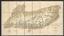
Terra Sancta quae in Sacris Terra Promissionis ol. Palestina [Karte], in: Gerardi Mercatoris Atlas, sive, Cosmographicae meditationes de fabrica mundi et fabricati figura, S. 517.
1 Karte aus Atlas Mercator, Gerhard Montanus, Petrus
Purveyorships in the Reign of Solomon. (1826)
1 : 1800000 Tanner, Henry S.
Homannův atlas světa
1 : 570000
Judaea seu Terra Sancta quae Hebraeorum sive Israelitarum in suas duodecim tribus divisa, secretis ab invicem regnis Juda, et Israel expressis insuper sex ultimi temporis ejusdem terrae provincijs
1 : 740000 ex conatibus geographicis Gulielmi Sanson [...] A Amsterdam : chez Pierre Schenk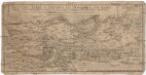
Palestinae terrae a Bersabea ad Dan vrbem svb regno Israel, typvs desrcriptvs [sic] pagella vna, qvae congrvat ad bibliorvm volvmina
1 : 711000 Palestina Lyttichius, Albertus Joachim Rhoeling, Paul Wolff Meyerpeck
Terra Sancta [Karte], in: Theatrum orbis terrarum, S. 408.
1 Karte aus Atlas Ortelius, Abraham Vrients, Jan Baptista
Palestine, Israelites.
Mitchell, Samuel Augustus
Judaea sive Terra Sancta quae Israelitarum suas duodecim tribus distincta, secretis ab invicem regnis Juda, et Israel expressis in super sex ejusdem terrae provincijs
1 : 650000 ex conatibus geographicis Gulielmi Sanson [...] Amst[erdam] : ex officina R. & J. Ottens

Palestine sous la domination romaine.
1 : 800000 Brue, Adrien Hubert, 1786-1832
Palestine (ancient).
1 : 1320000 Migeon, J.
Palestine.
1 : 1000000 Colton, G.W.
Palestine.
1 : 1000000 Andree, Richard; Times (London, England)
Palestine.
1 : 714649 Johnston, W. & A.K.
Palästina zur Zeit Jesu Christi und der Apostel
Palestina
Palestine.
1 : 1027000 Johnson, A.J.
Palestine sous la domination romaine.
1 : 800000 Picquet, C.
Palästina oder Kanaan zur Zeit des Israelitischen Reiches
Palestina Kiepert, Heinrich Arnd Geographisches Institut
![Sitvs terre sancte ivxta nvmerv[m] filior[um] Israel per apices sev pv[n]cta divisvs](https://images-2.georeferencer.com/images/iiif/754519088442/full/,300/0/native.jpg)

