Maps of Israel

Judaea seu Terra Sancta quae Hebraeorum sive Israelitarum in suas duodecim tribus divisa, secretis ab invicem regnis Juda, et Israel expressis insuper sex ultimi temporis ejusdem terrae provincijs
1 : 740000 ex conatibus geographicis Gulielmi Sanson [...] A Amsterdam : chez Pierre Schenk
Judaea sive Terra Sancta quae Israelitarum suas duodecim tribus distincta, secretis ab invicem regnis Juda, et Israel expressis in super sex ejusdem terrae provincijs
1 : 650000 ex conatibus geographicis Gulielmi Sanson [...] Amst[erdam] : ex officina R. & J. Ottens
Terre de Canaan á present la Palestine
1 : 1100000 Kanaán
Palestine sous la domination romaine.
1 : 800000 Picquet, C.
Palestine sous la Domination Romaine.
Levasseur, E.

Carta della Palestina sotto il dominio de'Romani
1 : 680000 Marzolla, Benedetto [Verlag nicht ermittelbar]
Homannův atlas světa
1 : 570000
Palestine sous la domination romaine.
1 : 800000 Brue, Adrien Hubert, 1786-1832
Palestine.
1 : 1000000 Colton, G.W.
Palestina za doby soudců a králů

Bez titulu: Historický Atlas

Palestine (with) Arabia Petraea.
1 : 1013760 Colton, G.W.
Palestina

Palestine.
1 : 1120000 Finley, Anthony
Terra Sancta [Karte], in: Theatrum orbis terrarum, S. 408.
1 Karte aus Atlas Ortelius, Abraham Vrients, Jan Baptista
Kaart van 't land Kanaan / naar de beste waarnemingen tot verstand van Num. XXI:14-31 ontworpen door R. Schutte ; J. van Jagen sculps. 1766
1 : 800000 Annotatie: Waarschijnlijk blad uit zakatlas Schutte, Rutger; Jagen, J. van Te Amsterdam : by J. Loveringh
Palestine ancienne & moderne d'après les sources les plus authentiques
1 : 600000 Andriveau-Goujon, E. (Eugène), 1832-1897 E. Andriveau-Goujon
Geographische Beschreibung des gelobten Landes Canaan, welches unsern Herrn und Seeligmacher Jesu Christo und seinen Aposteln durchwandert worden
1 : 1300000 Izrael
Turkey in Asia (Biblical Regions) The Holy Land And Its Borders.
1 : 696960 Fullarton, A. & Co.
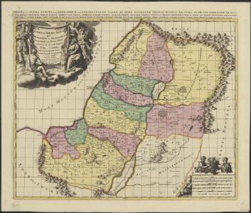
Palästina oder Kanaan zur Zeit des Israelitischen Reiches
Palestina Kiepert, Heinrich Arnd Geographisches Institut
La Judee, Canaan.
1 : 850000 Robert de Vaugondy, Gilles, 1688-1766
Palestine
1 : 1000000 Colton, G.W.

Palestine.
1 : 1000000 Andree, Richard; Times (London, England)
Palästina
Plastischer Schul-Atlas über alle Theile der Erde : in 24 Karten Woldermann, G Verlag von P. Eckerlein
Palestine.
1 : 1027000 Johnson, A.J.
Palaestina.
Palestina Kiepert, Heinrich Arnd
[Historisch-geographischer Atlas zu den allgemeinen Geschichtswerken von C. v. Rotteck, Pölitz u. Becker] : Palaestina von der Eroberung Josua's bis zum Untergange Juda's [&] Palaestine zur Zeit Jesu Christi nach Römischer Eintheilung
Julius Loewenberg Lithographie von B. Herder in Freiburg im Breisgau [Freiburg im Breisgau] : [Herder]