Maps of Israel

Palestine sous Constantin le Grand, 330 apres J.C.
1 : 2750000 Houze, Antoine Philippe
La Terre Sainte sous Salomon.
1 : 2800000 Houze, Antoine Philippe
Syria Phoenice, Syria Palaestina, Provinciae ab aerae Christianae anno 70 usque ad Diocletiani tempus; Phoenice, Coelesyria, Decapolis, Iudaea Herediadarum tempore.
1 : 2000000 Menke, Th.
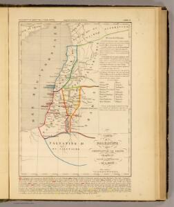
La Terre Sainte partagee en 12 tribus.
1 : 2800000 Houze, Antoine Philippe
Carte de la Terre Promise
1 : 1600000 Izrael
Terre Sainte divisee en royaumes d'Israel et de Juda de 975 a 588.
1 : 2700000 Houze, Antoine Philippe
151. Palestine and Lebanon. The World Atlas.
1 : 1250000 USSR (Union of Soviet Socialist Republics).

Palestine.
1 : 1120000 Finley, Anthony
Palestina za doby soudců a králů

Homannův atlas světa
1 : 570000
Palestine.
1 : 840000 Hall, S. (Sidney)
Purveyorships in the Reign of Solomon. (1826)
1 : 1800000 Tanner, Henry S.
Palestina nynější


Kaart van 't land Kanaan / naar de beste waarnemingen tot verstand van Num. XXI:14-31 ontworpen door R. Schutte ; J. van Jagen sculps. 1766
1 : 800000 Annotatie: Waarschijnlijk blad uit zakatlas Schutte, Rutger; Jagen, J. van Te Amsterdam : by J. Loveringh
Geographische Beschreibung des gelobten Landes Canaan, welches unsern Herrn und Seeligmacher Jesu Christo und seinen Aposteln durchwandert worden
1 : 1300000 Izrael
Palaestina.
1 : 1220000 Radefeld, Carl Christian Franz, 1788-1874
Palestine.
1 : 714649 Johnston, W. & A.K.

Palestine ancienne & moderne d'après les sources les plus authentiques
1 : 600000 Andriveau-Goujon, E. (Eugène), 1832-1897 E. Andriveau-Goujon
Palestine & Adjacent Countries.
1 : 1160000 Mitchell, Samuel Augustus
Palestine & Adjacent Countries.
1 : 1160000 Mitchell, Samuel Augustus
[Historisch-geographischer Atlas zu den allgemeinen Geschichtswerken von C. v. Rotteck, Pölitz u. Becker] : Palaestina von der Eroberung Josua's bis zum Untergange Juda's [&] Palaestine zur Zeit Jesu Christi nach Römischer Eintheilung
Julius Loewenberg Lithographie von B. Herder in Freiburg im Breisgau [Freiburg im Breisgau] : [Herder]
Judaea seu Terra Sancta quae Hebraeorum sive Israelitarum in suas duodecim tribus divisa, secretis ab invicem regnis Juda, et Israel expressis insuper sex ultimi temporis ejusdem terrae provincijs
1 : 740000 ex conatibus geographicis Gulielmi Sanson [...] A Amsterdam : chez Pierre Schenk
Palestine sous la domination romaine.
1 : 800000 Brue, Adrien Hubert, 1786-1832
Karte von Palästina
1 : 515000 Jeruzalém Velde, Charles William Meredith van de Justus Perthes
La Judee, Canaan.
1 : 850000 Robert de Vaugondy, Gilles, 1688-1766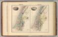
Palestine (ancient).
1 : 1320000 Migeon, J.