Maps of Israel

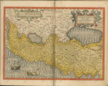
Terra Sancta quae in Sacris Terra Promissionis ol. Palestina [Karte], in: Gerardi Mercatoris Atlas, sive, Cosmographicae meditationes de fabrica mundi et fabricati figura, S. 517.
1 Karte aus Atlas Mercator, Gerhard Montanus, Petrus
Terra Sancta [Karte], in: Theatrum orbis terrarum, S. 408.
1 Karte aus Atlas Ortelius, Abraham Vrients, Jan Baptista
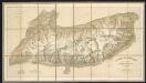
[Kaart], uit: Bartholomew's quarter-inch map of Palestine with orographical colouring
1 : 253440 Annotatie: Met 2 profielen van Palestina (OW en NZ); Met historische en moderne toponymen Edinburgh : Bartholomew
Judaea sive Terra Sancta quae Israelitarum suas duodecim tribus distincta, secretis ab invicem regnis Juda, et Israel expressis in super sex ejusdem terrae provincijs
1 : 650000 ex conatibus geographicis Gulielmi Sanson [...] Amst[erdam] : ex officina R. & J. Ottens
Palestine.
1 : 1000000 Colton, G.W.
Sitvs terre sancte ivxta nvmerv[m] filior[um] Israel per apices sev pv[n]cta divisvs
Palestina
Judaea seu Terra Sancta quae Hebraeorum sive Israelitarum in suas duodecim tribus divisa, secretis ab invicem regnis Juda, et Israel expressis insuper sex ultimi temporis ejusdem terrae provincijs
1 : 740000 ex conatibus geographicis Gulielmi Sanson [...] A Amsterdam : chez Pierre Schenk
Bez titulu: Historický Atlas

Palästina oder Kanaan zur Zeit des Israelitischen Reiches
Palestina Kiepert, Heinrich Arnd Geographisches Institut
A map of Palestine or the Holy Land : with the division into tribes and provinces / by A.H. Dufour
1 : 1100000 Annotatie: Engraved for "Three years in the East". &a Dufour, Auguste Henri [S.l. : s.n.]
Palestine.
1 : 1000000 Andree, Richard; Times (London, England)
Palaestina nach den zuverlässigsten alten und neuen Quellen
Hand-Atlas über alle Theile der Erde nach dem neuesten Zustande und über das Weltgebäude Stieler, Adolf bei Justus Perthes
Palestine, Israelites.
Mitchell, Samuel Augustus
Palaestina
Hand-Atlas über alle Theile der Erde nach dem neuesten Zustande und über das Weltgebäude Stieler, Adolf bei Justus Perthes
Palestine (with) Arabia Petraea.
1 : 1013760 Colton, G.W.
Afbeelding van 't land van Israël, naar deszelfs natuurlyke gesteltheid : waar in alle de zeën, rivieren en beeken, gelyk ook de bergen en dalen, de vlaktens, de woestynen, enz. dezes lands, die in de H.S. genoemt zyn, worden aangewezen
1 : 750000 door W.A. Bachiene J. van Jagen sculp. ; J.C. Philips fecit. te Gorinchem : by Nicolaas Goetzee
Terre de Canaan á present la Palestine
1 : 1100000 Kanaán
Palaestina.
Palestina Kiepert, Heinrich Arnd
Aardrijkskundige, plaatsbeschrijvende en geschiedkundige kaart van Palestina of het Heilige land
1 : 281000 oorspronkelijk geteekend door J.T. Assheton [...] bijzonderlijk wat de teekening betreft naauwkeurig herz. en verb. door E. Maaskamp ; onder toezigt en medew. van [...] J. Clarisse Te Amsterdam : bij E. Maaskamp, thans het eigendom van J. C. van Kesteren, boekhandelaar en boekdrukker te Amsterdam
Palastina.
1 : 1000000 Andree, Richard
Palestine sous la domination romaine.
1 : 800000 Picquet, C.
Palestine.
1 : 1000000 Colton, G.W.
Palaestina: ex veteris aevi monumentis ac recentiorum observationibus
1 : 450000 illustravit Marinus Didericus de Bruyn sculpsit Georgius Mayr Amstelodami : De Grebber
Palestine
1 : 1000000 Colton, G.W.
Terra Sancta : vita miraculis et passione Christi consecrata / autore N. Sanson Abbavilleo
1 : 3000000 Sanson, Nicolas [S.l. : s.n.]
Das Heilig Landt mit ausstheilung der zwölff Geschlechter
1 : 930000 1 Karte : Holzschnitt ; 29 x 35 cm Münster, Sebastian [Sebastian Henricpetri]
Palestine ou Terre Sainte.
1 : 610000 Lapie, M. (Pierre), 1779-1850
't Land Kanaan benevens Gilead verdeelt onder de XII stammen Israëls waar in de gelegendheid en uitgestrektheid van ieder erfdeel word aangewezen
1 : 700000 door W.A. Bachiene J. van Jagen mapp. sculpsit, et figur. apposit. sculpturam curavit ; J.C. Philips fecit. Uitgegeven te Gorinchem : by Nicolaas Goetzee