Maps of Martinique
Carte de I'isle de la Martinique colonie Francoise de l'une des isles Antilles de l'Amérique
1 : 183333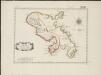
L'isle de la Martinique, scituée a 14 degrez 30 minutes de latitude septentrionale
1 : 216000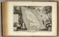
Colonies Francaises Martinique.
1 : 278000 Levasseur, Victor.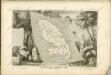
Martinico.
1 : 150000 Jefferys, Thomas
Insula Matanino Vulgo Martanico [Karte], in: Novus atlas absolutissimus, Bd. 9, S. 71.
1 Karte aus Atlas Janssonius Offizin
Insula Matanino vulgo Martanico
1 : 125000 in lucem edita per Nicolaum Vischer [Amsterdam] : nunc apud P. Schenk Jun.
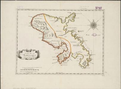
Carte de l'isle de la Martinique
Martinik Bellin, Jacques-Nicolas par les Heritiers de Homann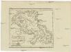
CHARTE von der Westindischen Insel MARTINIQUE
1 : 350000 Martinik Pluth, Fr.
INSULA MATANINO Vulgo MARTANICO
1 : 130000 Martinik Visscher, Nicolaus in lucem edita per Nicolaum Visscher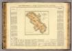
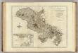
Martinique.
1 : 235000 Buchon, J. A. C.; Carey, H. C.; Lea, I.
Martinico : one of the Caribbee Islands in the West Indies, subject to the French
1 : 250000 Jefferys, Thomas, d. 1771 T. Jefferys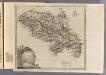
Martinico.
1 : 250000 Jefferys, Thomas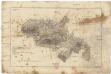
A view of the coast of Martinico
1 : 255000 Martinik Kitschin, Thomas Rodney
Martinico.
1 : 167366 Lucas, Fielding Jr.
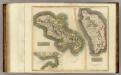
Martinico, Dominica.
1 : 200000 Thomson, John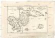
Isle de la Martinique
1 : 7320000 Guadeloupe Bonne, Rigobert André
A map of the islands of St. Lucia and Martinique, with part of Dominica and St. Vincents, shewing the two passages between Martinique and St. Lucia, and Martinique and Dominica, to Fort Royal Bay and harbour, the station of the French fleets ...
1 : 1
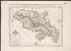
Antilles Francoises, isles voisines.
1 : 890000 L'Isle, Guillaume de, 1675-1726
Antilles Francoises, isles voisines.
1 : 890000 L'Isle, Guillaume de, 1675-1726
De Caribese eijlande tusschen St. Luzia en St. Christoffel
Lesser Antilles Gerard van Keulen
Carte des Antilles francoises et des isles voisines
1 : 870000
Tabula novissima atque accuratissima Caraibicarum insularum sive Cannibalum, quae etiam Antillae Gallicae dicuntur, item insulae Supraventum, et in Archipelago Mexicano sitae sunt, ac detectae a Christ. Columbo Ao. MCCCCLXXXXIII
1 : 960000
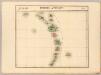
Map of the Windward Islands.
1 : 887040 Arrowsmith, John
Tabula novissima atque accuratissima Caraibicarum insularum sive Cannibalum : quae etiam Antillae Gallicae dicuntur, item insulae Supraventum, et in Archipelago Mexicano sitae sunt, ac detectae a Christ. Columbo Ao. MCCCCLXXXXIII
1 : 960000 Ottens, R. (Reinier), 1698-1750 by de Wed. I. Ottens, op den Nieuwen Dyk in de Werelt Kaart
Windward Islands.
1 : 887040 Stanford, Edward
Windward Islands.
1 : 2100000 Lea, I.
Leeward Islands.
1 : 887040 Stanford, Edward