Maps of Rhône-Alpes

Sabaudiae, Et Burgundiae Comitatus descriptio [Karte], in: Theatrum orbis terrarum, S. 38.
1 Karte aus Atlas Ortelius, Abraham
Savoy.
from A new systeme of the mathematicks: containing I. Arithmetick, as well natural and decimal, as in species, or the principles of algebra. II. Practical geometry, together with the first six books of Euclid's Elements, as also the eleventh and twelfth, symbo
Helvetia
1 : 2500000 1 Karte [Giovanni Antonio Magini aut.] ; [Girolamo Porro sculp.] [Haeredes Simones Galignani], [Venezia]
Suisse, or, Switzerland together with their allies & subjects etc
1 : 1500000 1 Karte by H. Moll [Verlag nicht ermittelbar], [London]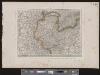
[Deutschland und der gröste Theil der umliegenden Staaten oder Mittel-Europa]
1 : 1100000 35 Karten [nach astronomischen Ortsbestimmungen und den besten Special-Karten, mit Rücksicht auf die neuesten Grenz-Bestimmungen entworfen, zufolge der Wiener Congress-Akte, des Pariser Friedens vom 21ten Nov. 1815, und der neuesten Austauschungen 1816 von H.H. Gotthold] ; [geschrieben und gestochen von H. Kliewer] ; sämtliche Gebürge im Atlas sind gezeichnet und gestochen von Paulus Schmidt, so wie auch die Sectionen 3,11,16,18,19,21,25,26,31 von demselben gestochen worden [Simon Schropp & Co.], [Berlin]
Sabavdiae, et Bvrgvndiae comitatus descriptio
1 Karte : Kupferdruck ; 30 x 21 cm Ortelius; Boileau de Bouillon s.n.
Helvetia
1 : 2500000 1 Karte [Philipp Clüver] [Verlag nicht ermittelbar], [Guelpherbyti]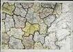
Carte de la république de France, no. 4
1 Blatt : 41 x 59 cm s.n.
<<Die>> Mineral-Quellen der Schweiz und ihrer nächsten Umgebungen
1 : 1200000 1 Karte Topogr. Anst. v. J. Wurster u. Comp. [Naturforschende Gesellschaft], [Zürich]
Nuova geografia delli stati de XIII cantoni de SS.ri Svizzeri, Grigioni, Valesani et de princepi con essi confinanti
1 Karte [Verlag nicht ermittelbar], [Erscheinungsort nicht ermittelbar]
Schweizerkarte von 1570
1 : 1200000 1 Karte cop. von A. Züricher (Section Wildhorn) ; Lith. R. Armbruster, Bern [Verlag der Expedition des Jahrbuches des S.A.C.], [Bern]
Helvetia, Rhaetia, Valesia
1 : 580000 1 Karte labore et studio Henrici Ludovici Muoss bei Joh. Jost Hiltensperger, Zug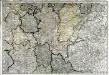
Neueste Generalkarte von Frankreich, 4
1 Blatt : 53 x 77 cm F.A. Schrämbl
Karte der Schweiz für den ersten geographischen Unterricht
1 : 1600000 1 Karte [von David Bürkli?] bey D. Bürkli, Zürich
Helvetia, Rhaetia, Valesia
1 : 580000 1 Karte labore et studio Henrici Ludovici Muoss bei dem Author, Zug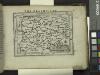
Delphinatus.
from Abraham Ortelius his epitome of the theater of the worlde / nowe latlye ... renewed and augmented ... by Micheal Coignet, mathematitian of Antwarpe.
[Helvetia antiqua]
1 : 2300000 4 Karten [Johann Ulrich Müller] [Andrea], [Frankfurt a. M.]
Sabavdiae, Et Bvrgvndiae Comitatus descriptio
1 : 1000000 Mollova mapová sbírka Boileau de Buillon, Gilles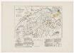
Historisch-geographischer Atlas der Schweiz: Karte XV: Schweizerische Sprachkarte nach der Volkszählung 1860
Mit Angabe der Orte mit über 2000 Einwohnern. Bearbeitung: Vögelin, J. K.; Meyer von Knonau, G.
<<Die>> Mineral-Quellen der Schweiz und ihrer nächsten Umgebungen
1 : 1200000 1 Karte Topogr. Anst. v. J. Wurster u. Comp. [Naturforschende Gesellschaft?], [Zürich?]
Postkarte von der Schweiz
1 : 860000 1 Karte [Franz Johann Joseph von Reilly] ; gestochen von Johann Stenger im von Reilly'schen Landkarten und Kunstwerke Verschleiss Komtoir, Wien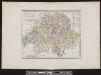
<<La>> république helvétique
1 : 1000000 1 Karte par Robert de Vaugondy ; gravé par E. Dussy Delamarche, [Paris?]
Tabula qua indicantur Confoederationis Helveticae loci in quibus tituli latini reperti sunt
1 : 1200000 1 Karte Topogr. Anstalt v. J. Wurster u. Comp., Winterthur
Rep. de la Suisse en 22 cantons
1 : 2800000 1 Karte in 2 Teilen auf 1 Bl. [Verlag nicht ermittelbar], [Paris?]
<<Die>> 8 alten Orte beim Abschluss des 50jährigen Friedens mit Oesterreich anno 1412
1 : 1700000 1 Karte Kartogr. Anstalt Hofer & Co., Zürich
<<Die>> 19 Cantone der Vermittlungsakte von 1803-15
1 : 1700000 1 Karte Kartogr. Anstalt Hofer & Co., Zürich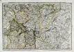
Quatrieme feuille contenant une partie de l'Orleanois, Berry, Nivernois, Bourbonnois, Auvergne, Lyonnois, Bourgogne, et Franche Comté
1 Blatt : 38 x 54 cm Bourgoin
Atlas für die Heimathskunde der Schweiz
1 : 19000000 1 Atlas (12, 12 Bl.) von J.S. Gerster ; gestochen von R. Leuzinger Dalp, Bern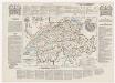
Historisch-geographischer Atlas der Schweiz: Karte X: Die konfessionelle Gestaltung der Schweiz seit der Reformation
Bearbeitung: Vögelin, J. K.; Meyer von Knonau, G.
![Sabaudiae, Et Burgundiae Comitatus descriptio [Karte], in: Theatrum orbis terrarum, S. 38.](https://images-2.georeferencer.com/images/iiif/576481775211/full/,300/0/native.jpg)

