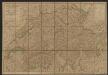
Maps of Jura

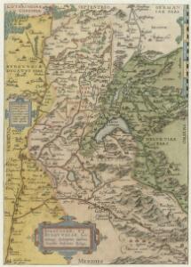
Sabavdiae, Et Bvrgvndiae Comitatus descriptio
1 : 1000000 Mollova mapová sbírka Boileau de Buillon, Gilles
Sabavdiae, et Bvrgvndiae comitatus descriptio
1 Karte : Kupferdruck ; 30 x 21 cm Ortelius; Boileau de Bouillon s.n.
Sabaudiae, Et Burgundiae Comitatus descriptio [Karte], in: Theatrum orbis terrarum, S. 38.
1 Karte aus Atlas Ortelius, Abraham
Carte de France, 8
2 Blätter : Kupferdruck ; 53 x 45 cm Crepy
Kurtz verzeichnete Vorstellung dess alten Helvetier-Lands mit ihren Anstoessen nach Julii Caesaris Beschreibung
1 Karte [Johannes Stumpf] [Verlag nicht ermittelbar], [Erscheinungsort nicht ermittelbar]
Kurtz verzeichnete Vorstellung dess alten Helvetier-Lands mit ihren Anstoessen nach Iulii Caesaris Beschreibung
1 : 700000 1 Karte [Johannes Stumpf] [Verlag nicht ermittelbar], [Zürich?]
Carte de la Suisse, ou l'on a marqué les routes suivies par Wil. Coxe
1 : 450000 1 Karte in 2 Teilen [par William Coxe] [Verlag nicht ermittelbar], [Erscheinungsort nicht ermittelbar]
[Deutschland und der gröste Theil der umliegenden Staaten oder Mittel-Europa]
1 : 1100000 35 Karten [nach astronomischen Ortsbestimmungen und den besten Special-Karten, mit Rücksicht auf die neuesten Grenz-Bestimmungen entworfen, zufolge der Wiener Congress-Akte, des Pariser Friedens vom 21ten Nov. 1815, und der neuesten Austauschungen 1816 von H.H. Gotthold] ; [geschrieben und gestochen von H. Kliewer] ; sämtliche Gebürge im Atlas sind gezeichnet und gestochen von Paulus Schmidt, so wie auch die Sectionen 3,11,16,18,19,21,25,26,31 von demselben gestochen worden [Simon Schropp & Co.], [Berlin]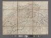
H. Keller's Reisecharte der Schweiz.
From Switzerland
<<Die>> vierdt Landtafel haltet inn die alt Helvetiam Iulii Cesaris mit iren Anstössen wie die im vierdten Buoch verzeichnet wirt
1 : 700000 1 Karte [Johannes Stumpf] [Froschauer], [Zürich]
Illustrations of the Glacier Systems of the Alps and of Glacial Phenomena in general
The physical atlas Johnston, Alexander Keith William Blackwood & Sons
Burgundiae Comitatus. [Karte], in: Theatrum orbis terrarum, S. 153.
1 Karte aus Atlas Ortelius, Abraham Vrients, Jan Baptista
Annexion de la Savoie
1 : 1100000 1 Karte P. Chaix Wurster, Winterthur
Übersichtskarte von Mittel - Europa

Helvetiae Descriptio
1 : 1200000 Mollova mapová sbírka Tschudi, Ägidius
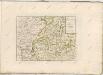
Gouvernements de Bourgogne, Franche Comté et Lyonnois
1 : 4870000 Burgundsko (Francie) Bonne, Rigobert André
[Helvetia antiqua]
1 : 2300000 4 Karten [Johann Ulrich Müller] [Andrea], [Frankfurt a. M.]
Genf, Lyon, Belfort, Macon
1 : 750000 Belfort (Francie) Fendl, J. K. u. k. Militärgeographisches Institut
Genf, Lyon, Belfort, Macon
1 : 750000 Belfort (Francie) K. k. militär-geographisches Institut
Annexion von Savoyen
1 : 1100000 1 Karte [von Paul Chaix] [Wurster], [Winterthur]
Tableau des chemins de fer et des routes de la Suisse
Mit Legende in französischer Sprache. Briques et fils, Genf Imp. Lith. de J. Dajoz, Genf
Gouvernements de Bourgogne et de Franche-Comté
1 Karte auf 4 Blättern : Kupferdruck ; 61 x 82 cm Mentelle; Tardieu; Dubuisson Mentelle
<<L'>>Helvetia o Paese de Svizzeri con li stati, che sono à medesimi collegati e soggetti, divisa ne suoi tredici cantoni, et altre iurisdittioni
1 Karte da Giacomo Cantelli da Viga Gio. Giacomo Rossi, Roma
Carte de l'ancien bassin formé par la réunion des grands lacs de la Suisse et des petits lacs intermédiaires
1 : 1130000 1 Karte Molière fecit [Mourer], [Lausanne]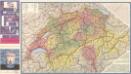
Die Schweizer Alpenpässe

Sabavdiae, et Bvrgvndiae comitatus descriptio
1 Karte : Kupferdruck ; 30 x 21 cm Ortelius; Boileau de Bouillon s.n.
Comitatus Burgundiae [Karte], in: Novus atlas absolutissimus, Bd. 4, S. 230.
1 Karte aus Atlas Janssonius Offizin
Fragment de l'Atlas de la Suisse par Tschudi 1538
Tschudi, Aegidius Hofer & Burger