Maps of Valais/Wallis

<<Der>> Canton Bern
1 : 390000 1 Karte gez. u. gest. v. J.J. Scheuermann Orell Füssli & Comp., Zuric [i.e. Zürich]
Karte des Kriegs-Schauplatzes der Schweiz
1 : 700000 2 Karten Verlag der Steiner'schen Buchhandlung, [Winterthur]
Nova Rhaetiae atque totius Helvetiae descriptio
1 : 350000 1 Karte auf 10 Bl. per Aegidium Tschudum Glaronensem Hofer & Burger, Zürich
[Südwestschweiz]
1 Karte : Kupferdruck ; 43 x 70 cm s.n.
[Wallis]
1 : 500000 1 Karte [Johannes Stumpf] [Christoffel Froschouer], [Zürych]
Atlas der Schweiz
1 : 450000 1 Atlas (18 Bl.) gez. u. gest. v. J. Scheurmann Orell Fussli, Zurich
<<Der>> Canton Bern
1 : 390000 1 Karte gez. u. gest. v. J.J. Scheuermann Orell Füssli & Comp., Zuric [i.e. Zürich]
Landtaflen
1 Atlas [von Johannes Stumpf] Christoffel Froschower, Zürych
Carte des Kantons Bern
1 : 400000 1 Karte Topogr. Anstalt von Wurster, Randegger & Co in Winterthur Schulbuchhandlung Antenen, Bern
<<Der>> Canton Bern
1 : 390000 1 Karte gez. u. gest. v. J.J. Scheuermann Orell Füssli & Comp., Zuric [i.e. Zürich]
[Fribourg, Solothurn]
1 : 1450000 [Stumme Kartenskizzen der ganzen Schweiz und der einzelnen Kantone zu Unterrichtszwecken] Schulbuchhandlung Antenen
Canton Bern sive illustris Helvetiorum respvblica Bernensis
1 Karte : Kupferdruck ; 45 x 55 cm Walser; Dorn edentibus Hommanianis Heredibus
Canton Bern sive illustris Helvetiorum respvblica Bernensis
1 Karte : Kupferdruck ; 46 x 55 cm Walser; Dorn edentibus Hommanianis Heredibus
Die Eisgebyrge des Schweizerlandes, mit allen dabey vorkommenden Mineralien
1 Karte auf 2 Blatt : Kupferdruck ; 39 x 81 cm Gruner; Zingg s.n.
Partie occidentale et meridionale de la Suisse et païs de Vallais
1 Karte : Kupferdruck ; 46 x 72 cm Monti chez F. Monty
Kanton Bern
1 : 1450000 [Stumme Kartenskizzen der ganzen Schweiz und der einzelnen Kantone zu Unterrichtszwecken] Schulbuchhandlung Antenen
Atlas der alten Eidgenossenschaft in 20 Karten: Kanton Bern
Originaltitel: Canton Bern sive Illustris Helvetiorum Respublica Bernensis cum Subditis suis et Confinibus. Zeichnung: Walser, Gabriel (1695-1776), reformierter Pfarrer, von Teufen AR Herausgeber: Homännische Erben
Carte des Kantons Bern
1 : 400000 1 Karte Topogr. Anstalt von Wurster, Randegger & Co in Winterthur Schulbuchhandlung Antenen (W.Kaiser), Bern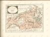

<<Die>> Kantone Bern und Solothurn
1 : 450000 1 Karte gez. von Rud. Gross Ch. Beyel, Zürich
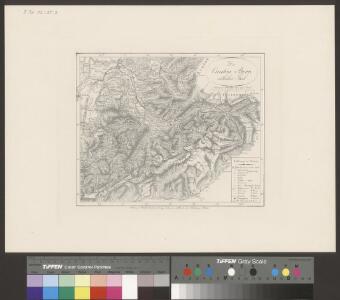
Geologische Kartenskizze der Alpen zwischen St. Gotthard & Montblanc
1 : 350000 Alpy (pohoří) Schmidt, Carl Ernst Finckh
[Exactissima Helvetiae, Rhaetiae, Valesiae ... tabula]
1 : 850000 9 Karten [Kopie von Adrian Braakman] [chez Pierre Schenk et Adrian Braakman], [Amsterdam]
Canton Bern sive Illustris Helvetiorum Respvblica Bernensis cum Subditis suis et Confinibus recenter delineata
1 : 430000 Mollova mapová sbírka Walser, Gabriel Dorn, Sebastian Homann, Johann Baptista - dědici
24) IX.N.E. ''Berne'', uit: Carte géologique de France
1 : 500000 Annotatie: Voor aanwezige bladen zie bladoverzicht [S.l : s.n.]
Canton Bern sive illustris helvetiorum respublica Bernensis
1 Karte : Kupferdruck ; 24 x 26 cm Walser Homännische Erben
Mappa geographica illustris Helvetiorum reipublicæ Bernensis
1 Karte : Kupferdruck ; 47 x 55 cm Seutter; Lotter; Seutter Matthäus Seutter
Karte des Cantons Bern
1 : 200000 Kutter, Wilhelm Rudolf ; Leuzinger, Rudolf J. Dalp'sche Buch- und Kunsthandlung (Karl Schmid)
Atlas novus Reipublicae Helveticae
1 Atlas ([40] Bl., 97 S.) bey Orell, Gessner und Compagnie, Zürich
Atlas der Schweiz
1 : 450000 1 Atlas (18 Bl.) gez. u. gest. v. J. Scheurmann Orell Fussli, Zurich