Maps of Vaud
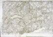
Partie occidentale et meridionale de la Suisse et païs de Vallais
1 Karte : Kupferdruck ; 46 x 72 cm Monti chez F. Monty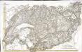
[Südwestschweiz]
1 Karte : Kupferdruck ; 43 x 70 cm s.n.
<<Les>> Suisses, leurs alliés et leurs sujets
1 : 230000 1 Karte auf 4 Bl. par A.H. Iaillot, 1703 chez l'auteur joignant les grands Augustins aux deux globes, Paris
<<Les>> Suisses, leurs alliés et leurs sujets
1 : 230000 1 Karte auf 4 Bl. par Iaillot chez l'auteur joignant les Grands Augustins aux deux Globes, Paris
[Exactissima Helvetiae, Rhaetiae, Valesiae ... tabula]
1 : 850000 9 Karten [Kopie von Adrian Braakman] [chez Pierre Schenk et Adrian Braakman], [Amsterdam]
<<Der>> Canton Bern
1 : 390000 1 Karte gez. u. gest. v. J.J. Scheuermann Orell Füssli & Comp., Zuric [i.e. Zürich]
Mappa geographica illustris Helvetiorum reipublicæ Bernensis
1 Karte : Kupferdruck ; 47 x 55 cm Seutter; Lotter; Seutter Matthäus Seutter
Canton Bern sive illustris Helvetiorum respvblica Bernensis
1 Karte : Kupferdruck ; 45 x 55 cm Walser; Dorn edentibus Hommanianis Heredibus
Canton Bern sive illustris Helvetiorum respvblica Bernensis
1 Karte : Kupferdruck ; 46 x 55 cm Walser; Dorn edentibus Hommanianis Heredibus
Canton Bern sive Illustris Helvetiorum Respvblica Bernensis cum Subditis suis et Confinibus recenter delineata
1 : 430000 Mollova mapová sbírka Walser, Gabriel Dorn, Sebastian Homann, Johann Baptista - dědici
[Fribourg, Solothurn]
1 : 1450000 [Stumme Kartenskizzen der ganzen Schweiz und der einzelnen Kantone zu Unterrichtszwecken] Schulbuchhandlung Antenen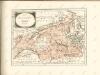

24) IX.N.E. ''Berne'', uit: Carte géologique de France
1 : 500000 Annotatie: Voor aanwezige bladen zie bladoverzicht [S.l : s.n.]
<<Das>> Wiflispurgergow
1 : 500000 1 Karte [von Johannes Stumpf] [Christoph Froschauer oder Johann Wolf], [Zürich]
Atlas der Schweiz
1 : 450000 1 Atlas (18 Bl.) gez. u. gest. v. J. Scheurmann Orell Fussli, Zurich
Freyburg in der Schweiz
1 : 200000 1 Karte entworfen und bearbeitet von Woerl ; gestochen unter seiner Leitung 1835 ; Lithographie von B. Herder Herder, Freiburg im Breisgau
Canton Bern sive illustris helvetiorum respublica Bernensis
1 Karte : Kupferdruck ; 24 x 26 cm Walser Homännische Erben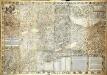
Inclitæ Bernatvm vrbis, cvm omni ditionis svæ agro et provinciis delineatio chorographica
1 Karte auf 18 Blatt : Kupferdruck ; 128 x 187 cm Schöpf; Martin; Krumm; Jobin; Saueracher; Meyer Albrecht Meyer
Inclitæ Bernatvm vrbis, cvm omni ditionis svæ agro et provinciis delineatio chorographica
1 Karte auf 18 Blatt : Kupferdruck ; je 46 x 65 cm Schöpf; Martin; Krumm; Jobin; Saueracher Adelbert Saueracher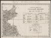
Das Wiflispurgergou [Karte], in: Gerardi Mercatoris Atlas, sive, Cosmographicae meditationes de fabrica mundi et fabricati figura, S. 267.
1 Karte aus Atlas Mercator, Gerhard Montanus, Petrus
<<Der>> Canton Bern
1 : 390000 1 Karte gez. u. gest. v. J.J. Scheuermann Orell Füssli & Comp., Zuric [i.e. Zürich]
<<Der>> Canton Bern
1 : 390000 1 Karte gez. u. gest. v. J.J. Scheuermann Orell Füssli & Comp., Zuric [i.e. Zürich]
Les Suisses Leurs Alliés et Leurs Suiets]
1 : 250000 Mollova mapová sbírka Jaillot, Alexis-Hubert Jaillot, Alexis Hubert
[Distanzenkarte der Schweiz]
1 : 250000 4 Karten nach dem topographischen Atlasse des Eidgenössischen Generalstabes reduziert unter der Direction des Generals G. H. Dufour ; gest. von H. Müllhaupt Eidg. Stabsbureau, Bern
Officielle Eisenbahn-Karte der Schweiz
1 : 250000 Südwest-Blatt [s.n.]
Carte topographique d'Allemagne contenant les cantons de Bern, et de Freyburg, les principautés de Neufchatel, et Vallangin, le territoire de Genève, et une partie comté de Bourgogne etc
1 : 210000 1 Karte fait par I. W. Iaeger chez l'Auteur., Francfort sur le Mein
Carte d'une partie des cantons de Berne de Fribourg du païs de Veau et du Valais &c
1 Blatt : Covens et Mortier
Nova Helvetiae tabula geographica, 3
1 Blatt : Pieter Schenk
Nova Helvetiae tabula geographica, 3
1 Blatt : Johann Jakob Scheuchzer


