Maps of Bern

Nova Rhaetiae atque totius Helvetiae descriptio
1 : 350000 1 Karte auf 10 Bl. per Aegidium Tschudum Glaronensem Hofer & Burger, Zürich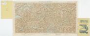
Foglio 1, uit: Carta d'Italia alla scala di 1:500.000 / Touring Club Italiano
1 : 500000 Annotatie: Voor aanwezige bladen zie overzichtsblad Touring Club Italiano Milano : Touring Club Italiano
<<Der>> Canton Bern
1 : 390000 1 Karte gez. u. gest. v. J.J. Scheuermann Orell Füssli & Comp., Zuric [i.e. Zürich]
[Wallis]
1 : 500000 1 Karte [Johannes Stumpf] [Christoffel Froschouer], [Zürych]
Argow cum parte merid. Zurichgow [Karte], in: Novus atlas absolutissimus, Bd. 4, S. 245.
1 Karte aus Atlas Janssonius Offizin
Argow cum parte merid. Zurichgow [Karte], in: Theatrum orbis terrarum, sive, Atlas novus, Bd. 1, S. 297.
1 Karte aus Atlas Blaeu, Joan Blaeu, Willem Janszoon
Argow cum parte merid. Zurichgow [Karte], in: Novus Atlas, das ist, Weltbeschreibung, Bd. 1, S. 254.
1 Karte aus Atlas Blaeu, Joan Blaeu, Willem Janszoon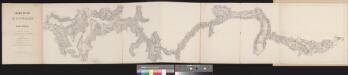
Chemin de fer par le St. Gotthard
1 : 100000 1 Karte dressé par A. Beckh et R. Gerwig Wurster, Winterthur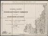
[Luzern, Zug, Uri, Schwyz, Unterwalden, Glarus, Teile Aargau und Zürich] [Karte], in: Gerardi Mercatoris Atlas, sive, Cosmographicae meditationes de fabrica mundi et fabricati figura, S. 270.
1 Karte aus Atlas Mercator, Gerhard Montanus, Petrus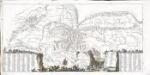
Die Eisgebyrge des Schweizerlandes, mit allen dabey vorkommenden Mineralien
1 Karte auf 2 Blatt : Kupferdruck ; 39 x 81 cm Gruner; Zingg s.n.
Raetiae veteris et exterae pars occidentalis qua Lepontii (gens perantiqua Cis ac Transalpina) continentur
1 : 550000 1 Karte [Matthias Hirtzgartner] [Joh. Rodolff Wolffen], [Zürich]
Reisekarte der Schweiz
1 : 500000 1 Atlas (1, 6 Bl.) gezeichnet von H. Keller und gestochen von J. Scheurmann = Carte routière de la Suisse / dessinée par H. Keller et gravée par J. Scheurmann bey Fuessli und Comp., Zürich
[Keller's Reisekarte der Schweiz]
1 : 500000 1 Karte auf 6 Bl. gezeichnet v. H. Keller ; gest. v. J.J. Scheurmann [Keller], Zürich
Atlas der alten Eidgenossenschaft in 20 Karten: Oberwallis und Unterwallis
Originaltitel: Vallesia superior ac inferior, Wallis. Mit Erklärung der Zeichen und Zeichnungen des Furkagletschers, des Gemmibergs, des Pissevache-Wasserfalls und des grossen St. Bernhards. Zeichnung: Walser, Gabriel (1695-1776), reformierter Pfarrer, von Teufen AR Herausgeber: Homännische Erben
Karte des Kriegs-Schauplatzes der Schweiz
1 : 700000 2 Karten Verlag der Steiner'schen Buchhandlung, [Winterthur]
<<Die>> Kantone Bern und Solothurn
1 : 450000 1 Karte gez. von Rud. Gross Ch. Beyel, Zürich
Landtaflen
1 Atlas [von Johannes Stumpf] Christoffel Froschower, Zürych
Carte des Kantons Bern
1 : 400000 1 Karte Topogr. Anstalt von Wurster, Randegger & Co in Winterthur Schulbuchhandlung Antenen, Bern
Geologische Kartenskizze der Alpen zwischen St. Gotthard & Montblanc
1 : 350000 Alpy (pohoří) Schmidt, Carl Ernst Finckh
Carte des Kantons Bern
1 : 400000 1 Karte Topogr. Anstalt von Wurster, Randegger & Co in Winterthur Schulbuchhandlung Antenen (W.Kaiser), Bern
Canton Bern sive illustris Helvetiorum respvblica Bernensis
1 Karte : Kupferdruck ; 45 x 55 cm Walser; Dorn edentibus Hommanianis Heredibus
Canton Bern sive illustris Helvetiorum respvblica Bernensis
1 Karte : Kupferdruck ; 46 x 55 cm Walser; Dorn edentibus Hommanianis Heredibus
[Argow] [Karte], in: Gerardi Mercatoris et I. Hondii Newer Atlas, oder, Grosses Weltbuch, Bd. 1, S. 265.
1 Karte aus Atlas Mercator, Gerhard und Hondius, Jodocus Jansson, Jan
Argow cum parte merid. Zurichgow [Karte], in: Le théâtre du monde, ou, Nouvel atlas contenant les chartes et descriptions de tous les païs de la terre, Bd. 1, S. 285.
1 Karte aus Atlas Blaeu, Willem Janszoon und Blaeu, Joan Blaeu, Willem Janszoon
ARGOW | cum parte merid. | ZVRICHGOW
Auctore Ger. Mercatore. [Amsterdam : Joan Blaeu]

Eisgebyrge des Schweizerlandes mit allen dabey vorkommenden Mineralien
Blatt Westteil Gruner, Gottlieb Sigmund ; Zingg, Adrian [Abraham Wagner, Sohn]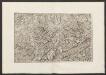
Militair Karte von Süd-Deutschland in 20 Sectionen
1 : 400000 17. Section Coulon, Alois von A. von Coulon
<<Der>> Canton Bern
1 : 390000 1 Karte gez. u. gest. v. J.J. Scheuermann Orell Füssli & Comp., Zuric [i.e. Zürich]


