Maps of Bern

<<Der>> Canton Bern
1 : 390000 1 Karte gez. u. gest. v. J.J. Scheuermann Orell Füssli & Comp., Zuric [i.e. Zürich]
<<Der>> Canton Bern
1 : 390000 1 Karte gez. u. gest. v. J.J. Scheuermann Orell Füssli & Comp., Zuric [i.e. Zürich]
Atlas der Schweiz
1 : 450000 1 Atlas (18 Bl.) gez. u. gest. v. J. Scheurmann Orell Fussli, Zurich
<<Der>> Canton Bern
1 : 390000 1 Karte gez. u. gest. v. J.J. Scheuermann Orell Füssli, Zuric [i.e. Zürich]
<<Der>> Canton Bern
1 : 390000 1 Karte gez. u. gest. v. J.J. Scheuermann Orell Füssli & Comp., Zuric [i.e. Zürich]
<<Der>> Canton Bern
1 : 390000 1 Karte gez. u. gest. v. J.J. Scheuermann Orell, Füssli & Comp., Zuric [i.e. Zürich]
Eisgebyrge des Schweizerlandes mit allen dabey vorkommenden Mineralien
Blatt Westteil Gruner, Gottlieb Sigmund ; Zingg, Adrian [Abraham Wagner, Sohn]
[Fribourg, Solothurn]
1 : 1450000 [Stumme Kartenskizzen der ganzen Schweiz und der einzelnen Kantone zu Unterrichtszwecken] Schulbuchhandlung Antenen
Charte des Kanton Bern
1 : 1546000 Bern (Švýcarsko : kanton) Schlieben Gleditsch
Partie occidentale et meridionale de la Suisse et païs de Vallais
1 Karte : Kupferdruck ; 46 x 72 cm Monti chez F. Monty
Carte des Cantons Bern
1 : 190000 Durheim, Karl C. Durheim
Karte des Cantons Bern
1 : 200000 Kutter, Wilhelm Rudolf ; Leuzinger, Rudolf J. Dalp'sche Buch- und Kunsthandlung (Karl Schmid)
[Wallis]
1 : 500000 1 Karte [Johannes Stumpf] [Christoffel Froschouer], [Zürych]
Carte de la Suisse avec les plans des cheflieux des 22 cantons
1 : 200000 1 Karte auf 8 Bl. dessinée et publié par Henri Keller ; Lithogr. von J. Schweizer = Charte der Schweiz mit den Grundrissen der Hauptorte der 22 Cantone Keller, Zürich
[Exactissima Helvetiae, Rhaetiae, Valesiae ... tabula]
1 : 850000 9 Karten [Kopie von Adrian Braakman] [chez Pierre Schenk et Adrian Braakman], [Amsterdam]
Freyburg in der Schweiz
1 : 200000 1 Karte entworfen und bearbeitet von Woerl ; gestochen unter seiner Leitung 1835 ; Lithographie von B. Herder Herder, Freiburg im Breisgau

Valais
1 : 1450000 [Stumme Kartenskizzen der ganzen Schweiz und der einzelnen Kantone zu Unterrichtszwecken] Schulbuchhandlung Antenen
Distanzenkarte von der Schweiz
1 : 200000 1 Karte in 8 Teilen nach den besten Hülfsquellen bearb. von R. Huber Wagner, Bern
Taschen-Atlas der Schweiz
1 Atlas (25 S., 20 Taf.) gezeichnet und gestochen von Emil Wagner = Atlas de poche de la Suisse : 26 cartes en couleurs / dessinées et gravées par Émile Wagner Eggimann, Genf
<<Der>> Canton Wallis
1 : 450000 1 Karte gez. u. gest. v. J. Scheuermann Orell Füssli & Comp., Zürich
<<Der>> Canton Wallis
1 : 450000 1 Karte gez. u. gest. v. J. Scheuermann Orell Füssli & Comp., Zürich
Die Verbreitung des Kropfes im Kanton Bern
1 : 200000 Kümmerly & Frey
Argow cum parte merid. Zurichgow [Karte], in: Le théâtre du monde, ou, Nouvel atlas contenant les chartes et descriptions de tous les païs de la terre, Bd. 1, S. 285.
1 Karte aus Atlas Blaeu, Willem Janszoon und Blaeu, Joan Blaeu, Willem Janszoon
[Argow] [Karte], in: Gerardi Mercatoris et I. Hondii Newer Atlas, oder, Grosses Weltbuch, Bd. 1, S. 265.
1 Karte aus Atlas Mercator, Gerhard und Hondius, Jodocus Jansson, Jan
ARGOW | cum parte merid. | ZVRICHGOW
Auctore Ger. Mercatore. [Amsterdam : Joan Blaeu]
Canton Bern
1 : 390000 Scheuermann, Johann Jakob Orell, Füssli & Comp.
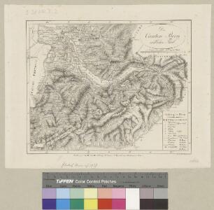
Carte d'une partie très interessante de la Suisse à l'usage des voyageurs
1 : 120000 Weiss, Johann Heinrich ; Meyer, Johann Rudolf J. R. Meyer