Maps of Rhodes

Insular. Aliquot Aegaei Maris Antiqua Descrip.[:] [Rhodus.] [Karte], in: Theatrum orbis terrarum, S. 419.
1 Karte aus Atlas Ortelius, Abraham
Insular. Aliquot Aegaei Maris Antiqua Descrip.[:] [Rhodus.] [Karte], in: Theatrum orbis terrarum, S. 517.
1 Karte aus Atlas Ortelius, Abraham Vrients, Jan Baptista
Carta topografica dell'isola di Rodi
1 : 25000 Rhodos, ostrov (Řecko) Istituto geografico militare
Rhodes, DR 47, Monolito
Rhodes, DR 47.Copied from an Italian map dated 1935. Great Britain. Army. Royal Engineers. Field Survey Company, 512th. [Cairo] : [Survey Directorate, Middle East]
Rhodes, DR 47, Lardo
Rhodes, DR 47. Copied from an Italian map dated 1935. Great Britain. Army. Royal Engineers. Field Survey Company, 512th. [Cairo] : [Survey Directorate, Middle East]
Rhodes, DR 47, Salaco
Rhodes, DR 47. Copied from an Italian map dated 1935. Great Britain. Army. Royal Engineers. Field Survey Company, 512th. [Cairo] : [Survey Directorate, Middle East]
Rhodes, DR 47, Castello
Rhodes, DR 47. Copied from an Italian map dated 1935. Great Britain. Army. Royal Engineers. Field Survey Company, 512th. [Cairo] : [Survey Directorate, Middle East]
Rhodes, DR 47, Monte Attario
Rhodes, DR 47. Copied from an Italian map dated 1935. Great Britain. Army. Royal Engineers. Field Survey Company, 512th. [Cairo] : [Survey Directorate, Middle East]
Rhodes, DR 47, Trianda
Rhodes, DR 47. Copied from an Italian map dated 1935. Great Britain. Army. Royal Engineers. Field Survey Company, 512th. [Cairo] : [Survey Directorate, Middle East]
Rhodes, DR 47, Afando
Rhodes, DR 47. Copied from an Italian map dated 1935. Great Britain. Army. Royal Engineers. Field Survey Company, 512th. [Cairo] : [Survey Directorate, Middle East]
Rhodes, DR 47, Alaerma
Rhodes, DR 47.Copied from an Italian map dated 1935. Great Britain. Army. Royal Engineers. Field Survey Company, 512th. [Cairo] : [Survey Directorate, Middle East]
Rhodes, DR 47, Apollona
Rhodes, DR 47. Copied from an Italian map dated 1935. Great Britain. Army. Royal Engineers. Field Survey Company, 512th. [Cairo] : [Survey Directorate, Middle East]
Rhodes, DR 47, Malona
Rhodes, DR 47. Copied from an Italian map dated 1935. Great Britain. Army. Royal Engineers. Field Survey Company, 512th. [Cairo] : [Survey Directorate, Middle East]
Rhodes, DR 47, Cattavia
Rhodes, DR 47. Copied from an Italian map dated 1935. Great Britain. Army. Royal Engineers. Field Survey Company, 512th. [Cairo] : [Survey Directorate, Middle East]
Rhodes, DR 47, Lacania
Rhodes, DR 47. Copied from an Italian map dated 1935. Great Britain. Army. Royal Engineers. Field Survey Company, 512th. [Cairo] : [Survey Directorate, Middle East]
Rhodes, DR 47, Villanova
Rhodes, DR 47. Copied from an Italian map dated 1935. Great Britain. Army. Royal Engineers. Field Survey Company, 512th. [Cairo] : [Survey Directorate, Middle East]
Siége de Rhodes par Souleiman I
Nouvel atlas physique politique et historique de l'Empire ottoman et des états limitrophes en Europe, en Asie et en Afrique, en quarante feuilles Hellert, J.J. Bellizard, Dufour et Cie
Isola Di Piscopi, Dodecanese Islands 1:25,000 (1953)
Sheet 24 of the 53-sheet series: Dodecanese Islands 1:25,000, A.M.S. Series M801. Relief shown by contours, spot heights and rock drawings. Contour interval: 10 m. United States. Army. Corps of Engineers Washington, D.C. : Army Map Service, Corps of Engineers, U.S. Army.
Archipelagi Insularum Aliquot Descrip., [Rodus] [Karte], in: Theatrum orbis terrarum, S. 341.
1 Karte aus Atlas Ortelius, Abraham Vrients, Jan Baptista
Rhodus Ins. [Karte], in: Gerardi Mercatoris Atlas, sive, Cosmographicae meditationes de fabrica mundi et fabricati figura, S. 523.
1 Karte aus Atlas Mercator, Gerhard Montanus, Petrus
Archipelagi Insularum Aliquot Descrip., [Rodus] [Karte], in: Theatrum orbis terrarum, S. 246.
1 Karte aus Atlas Ortelius, Abraham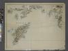
Sheet 14. 1: 250,000. / dressée par Henri Kiepert d'après ses propres observations et d'autres levées pour la plupart inédites = Map of the western part of Asia Minor
From Specialkarte vom westlichen Kleinasien nach seinen eigenen Reisen und anderen grösstenteils noch unveröffentlichten Routenaufnahmen bearbeitet von Heinrich Kiepert = Carte de la partie occidentale de l 'Asie mineure
CYCLADES | INSVLÆ | IN MARE ÆGÆO, | hodie | ARCHIPELAGO
Auctore | I. LAVRENBERGIO Amsterdami, J. Blaeu excudit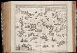
Archipelagi meridionalis, seu Cycladum insularum accurata delineatio / auctore I. Laurenbergio
1 : 650000 Annotatie: Kaart uitgegeven in de periode 1650-1662; Origineel is Blad 171 in atlas factice; Annotatie geografische gegevens: 4 schaalstokken: 8 Mill. Germ., en: 10 Mill. Gall., en: 30 Mill. Ital., en: 300 Stadia [S.l.] : [s.n.]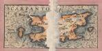
Archipelagi Insularum Aliquot Descrip., [Scarpanto] [Karte], in: Theatrum orbis terrarum, S. 246.
1 Karte aus Atlas Ortelius, Abraham
Candia cum Insulis aliquot circa Graeciam[:] [Scarpanto] [Karte], in: Gerardi Mercatoris et I. Hondii Newer Atlas, oder, Grosses Weltbuch, Bd. 2, S. 336.
1 Karte aus Atlas Mercator, Gerhard und Hondius, Jodocus Jansson, Jan
Kos, Nisero and Piscopi (1848)
Archipelago. The Islands of Kos, Nisero and Piscopi, etc.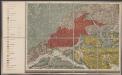
Candia cum Insulis aliquot circa Graeciam[:] [Scarpanto] [Karte], in: Gerardi Mercatoris Atlas, sive, Cosmographicae meditationes de fabrica mundi et fabricati figura, S. 493.
1 Karte aus Atlas Mercator, Gerhard Montanus, Petrus
Archipelagi Meridionalis seu Cycladum Insularum accurata Delineatio. [Karte], in: Novus atlas absolutissimus, Bd. 10, S. 234.
1 Karte aus Atlas Janssonius Offizin
![Insular. Aliquot Aegaei Maris Antiqua Descrip.[:] [Rhodus.] [Karte], in: Theatrum orbis terrarum, S. 419.](https://images-2.georeferencer.com/images/iiif/197579874790/full/,300/0/native.jpg)

